
—
Total Campsites
Campground
—
Reservable Sites
Check by phone
—
Accessible
ADA-compliant sites
Organization
Overview
About NIZHONI
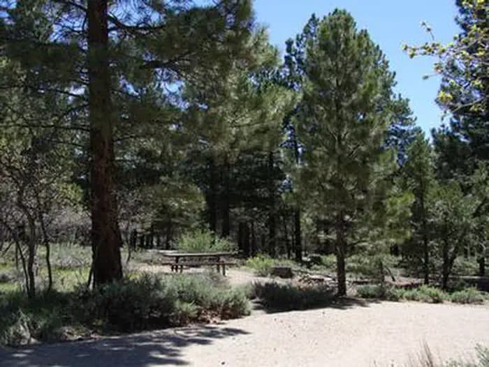
Overview Nizhoni Campground sits in the Manti-LaSal National Forest in southeast Utah, at the foot of the Abajo Mountains. Recreation Popular activities include hiking, wildlife viewing and off-road vehicle riding. Several trailheads are nearby, including Shay Ridge, Aspen Flat and Red Ledges. The Abajo Loop State Scenic Backway passes by the campground. It leads from the desert floor and red rock canyons to steep mountains over 10,000 feet high, with overlooks and panoramic views. The byway is suitable for passenger vehicles from late spring through fall but is not recommended for large RVs. Facilities Popular activities include hiking, wildlife viewing and off-road vehicle riding. Several trailheads are nearby, including Shay Ridge, Aspen Flat and Red Ledges. The Abajo Loop State Scenic Backway passes by the campground. It leads from the desert floor and red rock canyons to steep mountains over 10,000 feet high, with overlooks and panoramic views. The byway is suitable for passenger vehicles from late spring through fall but is not recommended for large RVs. Natural Features Towering Ponderosa pines forest the site, offering partial shade. Gambel oaks and sagebrush dot the landscape. The campground sits at an elevation of 7,000 feet, and summer temperatures range from 80-90 degrees during the day and 55-65 degrees at night. Mule deer, wild turkeys, Abert's squirrels and the occasional black bear may be seen in the area. Nearby Attractions Other attractions in the area include Canyonlands, Arches and Mesa Verde National Parks, Dark Canyon Wilderness, Edge of the Cedars State Park, Lake Powell and numerous archaeological sites.
- Map coordinates are available for trip planning.

Reservations & Contact
Plan your stay
Phone
435-587-2041
Getting There
From Blanding, Utah, travel north on Highway 191 approximately two miles. Turn left on E. Pinion Ridge Road (National Forest Access sign: Dry Wash Reservoir) and proceed 3/4-mile to the stop sign. Turn right on Forest Road 079 and continue approximately 10 miles to the campground on the right side of the road.
FAQ
Common questions
Everything you need to know before your trip to NIZHONI.
How do reservations work for NIZHONI?
Reservation availability for NIZHONI can vary by season and campsite type. Check the contact and access section before booking.
What campsite types are available at NIZHONI?
Campsite type details are limited right now. Check back as this listing is enriched.
Where is NIZHONI located?
NIZHONI is in Utah. Coordinates: 37.7817, -109.5397.
Keep Exploring