
Campgrounds in New Mexico
Camp in enchanting desert landscapes and mountain ranges in the Land of Enchantment
24
Campgrounds listed
100%
With photos
100%
Detailed descriptions
Campground
Top campground type
Highlights
Featured campgrounds in New Mexico
Explore by campground name letter
Jump to A-Z landing hubs for stronger discovery paths beyond New Mexico.
All campgrounds
Showing 24 campgrounds

Overview Rob Jaggers Camping Area: This site consists of 2 large day use parking areas, 2 vault toilets, and facilities for staging horseback riding. There are 27 campsites with electricity and potable water hookups, and other potable water outlets scattered throughout. Campites and horse corrals are first-come, first-served . Camping is restricted to the campground only and no camping is permitted in the day use parking area. Occasionally the campground is rented out for Special Recreation Permitted events. When this happens notification will be made to the public in the form of a news release. BLM requires a Special Recreation Permit for some events. Please contact the Roswell Field Office to determine if a Special Recreation Permit is required for your event . There is water and electricity located at the group shelter. To make group shelter reservations or for any other Rob Jaggers Campground information, please contact the camp host at 575-322-0030. For other information please contact the Roswell Field Office at 575-627-0272 . Recreation RECREATION OPPORTUNITIES This unique NCA has many opportunities for hiking, caving, horseback riding, mountain biking, camping, visiting cultural and historic sites, picnicking, hunting, wildlife viewing, nature study, and photography. There is drinking water and toilets at the Rob Jaggers Camping Area and at the Cave Campgrounds. Trails (Hiking, Biking, Horseback Riding) Fort Stanton NCA has 73 miles of sustainable horseback, mountain biking, and hiking trails that wind through open meadows and canyons. Trails are marked with flexible fiberglass markers with the trail name or an arrow attached to the marker. Cross-country horse and foot travel is allowed. Mountain bikes are strongly encouraged to stay on established trails to protect the rider as well as the landscape. The trails offer great views of the surrounding Sacramento and Capitan Mountains. The majority of the trails start at the Rob Jaggers Camping Area on NM 220 where you will find hitching rails, water for your animals, and a vault toilet. Rio Bonito Petroglyph National Recreation Trail Hike the Petroglyph Trail along the Rio Bonito and glimpse into the past. At the midpoint of the Trail, in the river bed, is Petroglyph Rock. Etched on this rock are depictions of an ancient people known as the Jornada Mogollon who have long since left the area. Very little evidence has stood the test of time, but here on the Petroglyph Trail remains a link to the culture and lifestyle of these ancient people. The Trail can be reached from NM 220, west of the Sierra Blanca Regional Airport. Follow the highway signs stating “Upper Rio Bonito” to the bottom of the hill and turn right for approximately 250 ft then take the next left until you reach the trailhead (high-clearance vehicles are recommended). Petroglyph Rock is a short 450 ft walk from the parking area. The loop trail is approximately 2.1 miles in total length and is easy-to-moderate hiking with a few hills and areas with loose footing. Plan to spend approximately one hour on the Trail. Historical Sites Historic Fort Stanton is one of very few intact frontier forts in the West. Many of the original Fort buildings still stand. From 1855 to 1896, the Fort played host to some of the most colorful units and personalities of the West, including the 9th Cavalry, and the 24th, 57th, and 125th Infantry Buffalo Soldiers, Billy the Kid, Lew Wallace, Colonel Kit Carson, and General “Black Jack” Pershing. The post was also a Merchant Marine hospital & tuberculosis sanatorium, and World War II prisoner of war camp. In 1953, the Fort and 1,320 surrounding acres were transferred from Federal to State ownership, becoming a state hospital and training school until 1955. Today, the Fort area is active with other State activities and the Fort Stanton Museum is open on a daily basis (http://fortstanton.org/). Caving Fort Stanton Cave With over 40 miles of mapped passages, the Cave is normally open for recreational caving under permit from April 15 to November 1. However, due to the threat of White Nose Syndrome (WNS), which has killed 8 million bats in the eastern and southern states, and has been identified nearby in Texas, the Cave has been placed in a recreational caving moratorium pending research and monitoring of the unwanted arrival of WNS. The Cave is widely known for its rare velvet formations, and there are also interesting helictites, aragonite, selenite needles, and various forms of gypsum. During the winter months the Cave is closed to protect hibernating bats. The Cave is gated to protect other unique resources and to prevent unsupervised visitation. Please check back with this website for any changes to the recreational caving moratorium. Snowy River Very slow moving groundwater dissolved the grayish-brown limestone in which the Cave is formed and recrystallized that limestone into a white-colored mineral called calcite. Through numerous infillings of groundwater saturated with calcite, followed by draining and drying, repeated coats of calcite were laid on the bottom of the Cave through the entire 11 miles of Snowy River passage that has been surveyed to date. This unique white crystalline deposit glistens like snow and may be the longest calcite formation in North America. Several endemic microorganisms have been discovered in this new section of the Cave. In this sunless environment, species living here do not get their energy from the sun. Instead, they chemically break down rock. In the process, they create chemical byproducts that could have pharmaceutical uses. There are also several species that have formed symbiotic relationships with each other. Continuing exploration and scientific research will help us better understand the formation of caves in this area, improve our understanding of groundwater hydrology of the region, and increase our knowledge of the biology of the Cave. In the years to come, many new biological discoveries are anticipated. Due to the scientific importance of the Cave, the Snowy River passage is not open to the public. BLM is planning interpretive products in the future so the public can enjoy and better understand this unique resource. Camping The Fort Stanton NCA is open to overnight camping with a 14-day maximum length of stay. To camp, vehicles may pull off any of the dirt roads, but no more than 90 feet from the road. There are two formal camping areas: The Rob Jaggers Camping Area on NM 220 and the small Cave Campground near Fort Stanton Cave entrance. Cave Campground - Several tables and fire rings are located here, as well as a vault toilet. The access road is graveled. Facilities RECREATION OPPORTUNITIES This unique NCA has many opportunities for hiking, caving, horseback riding, mountain biking, camping, visiting cultural and historic sites, picnicking, hunting, wildlife viewing, nature study, and photography. There is drinking water and toilets at the Rob Jaggers Camping Area and at the Cave Campgrounds. Trails (Hiking, Biking, Horseback Riding) Fort Stanton NCA has 73 miles of sustainable horseback, mountain biking, and hiking trails that wind through open meadows and canyons. Trails are marked with flexible fiberglass markers with the trail name or an arrow attached to the marker. Cross-country horse and foot travel is allowed. Mountain bikes are strongly encouraged to stay on established trails to protect the rider as well as the landscape. The trails offer great views of the surrounding Sacramento and Capitan Mountains. The majority of the trails start at the Rob Jaggers Camping Area on NM 220 where you will find hitching rails, water for your animals, and a vault toilet. Rio Bonito Petroglyph National Recreation Trail Hike the Petroglyph Trail along the Rio Bonito and glimpse into the past. At the midpoint of the Trail, in the river bed, is Petroglyph Rock. Etched on this rock are depictions of an ancient people known as the Jornada Mogollon who have long since left the area. Very little evidence has stood the test of time, but here on the Petroglyph Trail remains a link to the culture and lifestyle of these ancient people. The Trail can be reached from NM 220, west of the Sierra Blanca Regional Airport. Follow the highway signs stating “Upper Rio Bonito” to the bottom of the hill and turn right for approximately 250 ft then take the next left until you reach the trailhead (high-clearance vehicles are recommended). Petroglyph Rock is a short 450 ft walk from the parking area. The loop trail is approximately 2.1 miles in total length and is easy-to-moderate hiking with a few hills and areas with loose footing. Plan to spend approximately one hour on the Trail. Historical Sites Historic Fort Stanton is one of very few intact frontier forts in the West. Many of the original Fort buildings still stand. From 1855 to 1896, the Fort played host to some of the most colorful units and personalities of the West, including the 9th Cavalry, and the 24th, 57th, and 125th Infantry Buffalo Soldiers, Billy the Kid, Lew Wallace, Colonel Kit Carson, and General “Black Jack” Pershing. The post was also a Merchant Marine hospital & tuberculosis sanatorium, and World War II prisoner of war camp. In 1953, the Fort and 1,320 surrounding acres were transferred from Federal to State ownership, becoming a state hospital and training school until 1955. Today, the Fort area is active with other State activities and the Fort Stanton Museum is open on a daily basis (http://fortstanton.org/). Caving Fort Stanton Cave With over 40 miles of mapped passages, the Cave is normally open for recreational caving under permit from April 15 to November 1. However, due to the threat of White Nose Syndrome (WNS), which has killed 8 million bats in the eastern and southern states, and has been identified nearby in Texas, the Cave has been placed in a recreational caving moratorium pending research and monitoring of the unwanted arrival of WNS. The Cave is widely known for its rare velvet formations, and there are also interesting helictites, aragonite, selenite needles, and various forms of gypsum. During the winter months the Cave is closed to protect hibernating bats. The Cave is gated to protect other unique resources and to prevent unsupervised visitation. Please check back with this website for any changes to the recreational caving moratorium. Snowy River Very slow moving groundwater dissolved the grayish-brown limestone in which the Cave is formed and recrystallized that limestone into a white-colored mineral called calcite. Through numerous infillings of groundwater saturated with calcite, followed by draining and drying, repeated coats of calcite were laid on the bottom of the Cave through the entire 11 miles of Snowy River passage that has been surveyed to date. This unique white crystalline deposit glistens like snow and may be the longest calcite formation in North America. Several endemic microorganisms have been discovered in this new section of the Cave. In this sunless environment, species living here do not get their energy from the sun. Instead, they chemically break down rock. In the process, they create chemical byproducts that could have pharmaceutical uses. There are also several species that have formed symbiotic relationships with each other. Continuing exploration and scientific research will help us better understand the formation of caves in this area, improve our understanding of groundwater hydrology of the region, and increase our knowledge of the biology of the Cave. In the years to come, many new biological discoveries are anticipated. Due to the scientific importance of the Cave, the Snowy River passage is not open to the public. BLM is planning interpretive products in the future so the public can enjoy and better understand this unique resource. Camping The Fort Stanton NCA is open to overnight camping with a 14-day maximum length of stay. To camp, vehicles may pull off any of the dirt roads, but no more than 90 feet from the road. There are two formal camping areas: The Rob Jaggers Camping Area on NM 220 and the small Cave Campground near Fort Stanton Cave entrance. Cave Campground - Several tables and fire rings are located here, as well as a vault toilet. The access road is graveled. Natural Features Fort Stanton Snowy River Cave National Conservation Area: Surrounding the Rob Jagger's campground is the Fort Stanton Snowy River Cave National Conservation Area (NCA). At around 6300' elevation the NCA offers a diverse habitat of High Desert cedar/juniper hillsides with Ponderosa Pine stringers and hardwoods meandering through the canyon bottoms. Petroglyph Rock: Along the Rio Bonito River petroglyph trail is Petroglyph Rock. Etched on this rock are depictions of an ancient people known as the Jornada Mogollon who have long since left the area. Very little evidence has stood the test of time, but here on the Petroglyph Trail remains a link to the culture and lifestyle of these ancient people. Snowy River Cave: The Cave is widely known for its rare velvet formations, and there are also interesting helictites, aragonite, selenite needles, and various forms of gypsum. During the winter months the Cave is closed to protect hibernating bats. The Cave is gated to protect other unique resources and to prevent unsupervised visitation. Nearby Attractions Nearby camping/recreation opportunities: The BLM's Fort Stanton National Conservation Area has 93 miles of sustainable horseback, mountain biking, and hiking trails that wind through open meadows and canyons. Trails are marked with flexible fiberglass markers with the trail name or an arrow attached to the marker. Cross-country horse and foot travel is allowed. Mountain bikes are strongly encouraged to stay on established trails to protect the rider as well as the landscape. The trails offer great views of the surrounding Sacramento and Capitan Mountains. The majority of the trails start at the Rob Jaggers Camping Area on NM 220 where you will find hitching rails, water for your animals, and a vault toilet. Additonal nearby attractions include Capitan, Lincoln, and Ruidoso. Capitan, located approximately 5 miles west of the Rob Jagger's Campground on U.S. Highway 380, is known as the birthplace of Smokey Bear, and features a popular visitor center. Lincoln, located 8 miles east on U.S. Highway 380, is famous as the site of the historic Lincoln County Wars as well as the exploits of Billy the Kid and Sheriff Pat Garrett. Ruidoso is a popular resort town that features a horse racetrack, the Ski Apache skiing resort, and the Inn of the Mountain Gods casino Valley of Fires Recreation Area: The Bureau of Land Management maintains and manages the Valley of Fires Recreation area, which is located four miles west of Carrizozo, NM, on US Highway 380 approximatley 27 miles west of Rob Jagger's Campground. Valley of Fires offers both camping and day use. Most of the campsites have 30 and 50 amp electrical hookups, water hookups, picnic shelters, tables, trash cans and barbeque grills.Other water hydrants are scattered throughut the recreation area. Two of the RV sites are accessible, as are the restrooms. Showers are provided in the main restroom/shower house. An RV dump station is also available. Two group shelters are wheelchair accessible and available for rental. The 3/4 mile Malpais Nature Trail offers a close-up look of the lava surface. Carrizozo Land Partnership: The Carrizozo Land Partnership (CLP) provides access to recreators wishing to enter public lands managed by the BLM, between the Carrizozo Lava Flow and the White Sands Missile Range which can only be reached by crossing private land. The CLP, a partnership between the BLM, private land owners and ranchers of this area, has arranged for public access to BLM lands in this area by a vehicle pass process. The form required for applying for access can be found here: https://www.blm.gov/programs/recreation/permits-and-passes/lotteries-and-permit-systems/new-mexico/carrizozo-land-partnership Please note that a vehicle pass is required for each vehicle (including OHVs) that will be entering the partnership area. Once on the BLM lands in the area, the public is allowed to hunt, camp, hike, observe wildlife and other appropriate recreational activities. This partnership provides access to many miles of roads and thousands of acres of public lands for recreational enjoyment. The roads are extremly rocky and rough and a high clearance 4x4 vehicle or side by side is recomended. Terrain is from flat to rolling, with some bluffy/hilly country overlooking the lava flows. High desert plant species inhabit this area, ranging from desert shrubs, multiple varieties of cactus and cedar/juniper trees. contact_info
View details →
Overview Valley of Fires recreation area is located immediately adjacent to the Malpais Lava Flow. Approximately 5,000 years ago, Little Black Peak erupted and flowed 44 miles into the Tularosa Basin, filling the basin with molten rock. The resulting lava flow is four to six miles wide, 160 feet thick and covers 125 square miles. The lava flow is considered to be one of the youngest lava flows in the continental United States. The Bureau of Land Management maintains and manages the Valley of Fires Recreation area, which is located four miles west of Carrizozo, NM, on US Highway 380. Valley of Fires offers both camping and day use. 20 of the campsites have 30 and 50 amp electrical hookups and water hookups, all sites have picnic shelters, tables, trashcans and barbeque grills. Two of the RV sites are accessible, as are the restrooms. Showers are provided in the main restroom/shower house. An RV dump station is also available. Two group shelters are accessible and available for rental. The 3/4 mile Malpais Nature Trail offers a close-up look of the lava surface. Recreation Valley of Fires Recreation area offers opportunities for RV Camping (both full-service and primitive camp sites), tent camping and day use. The Malpais Nature trail offers a unique experience of getting trail users out into the lava. The trail is paved and accessible. Each campsite and group shelter is equipped with picnic shelter and picnic table(s) for the public's enjoyment. Facilities Valley of Fires Recreation area offers opportunities for RV Camping (both full-service and primitive camp sites), tent camping and day use. The Malpais Nature trail offers a unique experience of getting trail users out into the lava. The trail is paved and accessible. Each campsite and group shelter is equipped with picnic shelter and picnic table(s) for the public's enjoyment. Natural Features From a distance, Valley of Fires appears as barren rock but when you walk through the nature trail there are many varieties of flowers, cactus, trees and bushes typical of the Chihuahuan desert. Animals include bats, roadrunners, quail, cottontails, mule deer, barbary sheep, and lizards. It's also a virtual birdwatcher's paradise with great horned owls, burrowing owls, turkey vultures, hawks, gnat catchers, cactus wrens, sparrows and golden eagles. Nearby Attractions Carrizozo Land Partnership **The Carrizozo Land Partnership vehicle pass page is temporarily unavailable and the Roswell Field Office is currently unable to issue vehicle passes to cross private lands while collection policies for personal identifiable information are updated. All other open BLM lands remain accessible during this time. For more information please contact the Roswell Field Office at 575-627-0272.** The Carrizozo Land Partnership provides access to recreators wishing to enter public lands managed by the BLM, between the Carrizozo Lava Flow and the White Sands Missile Range which can only be reached by crossing private land. The CLP, a partnership between the BLM, private land owners and ranchers of this area, has arranged for public access to BLM lands in this area by a vehicle pass process. Once on the BLM lands in the area, the public is allowed to hunt, camp, hike, observe wildlife and other appropriate recreational activities. This partnership provides access to many miles of roads and thousands of acres of public lands for recreational enjoyment. Terrain is from flat to rolling, with some bluffy/hilly country overlooking the lava flows. High desert plant species inhabit this area, ranging from desert shrubs, multiple varieties of cactus and cedar/juniper trees. Other nearby camping/recreation opportunities: Other nearby fee areas include campgrounds in the Lincoln National Forest, and the BLM Rob Jagger's Campground. There are numerous private RV Campgrounds in the area as well. Additonal nearby attractions include Capitan, Lincoln, and Ruidoso. Capitan, located 24 miles east of the Valley of Fires on U.S. Highway 380, is known as the birthplace of Smokey Bear, and features a popular visitor center. Lincoln, located 37 miles east on U.S. Highway 380, is famous as the site of the historic Lincoln County Wars as well as the exploits of Billy the Kid and Sheriff Pat Garrett. Ruidoso is a popular resort town that features a horse racetrack, the Ski Apache skiing resort, and the Inn of the Mountain Gods casino. The BLM's Fort Stanton National Conservation Area, located approximately 27 miles east of the Valley of Fires on U.S. Highway 380, has 93 miles of sustainable horseback, mountain biking, and hiking trails that wind through open meadows and canyons. Trails are marked with flexible fiberglass markers with the trail name or an arrow attached to the marker. Cross-country horse and foot travel is allowed. Mountain bikes are strongly encouraged to stay on established trails to protect the rider as well as the landscape. The trails offer great views of the surrounding Sacramento and Capitan Mountains. The majority of the trails start at the Rob Jaggers Campground on NM 220 where you will find excellent camping opportunities, water for your animals, and vault toilets.
View details →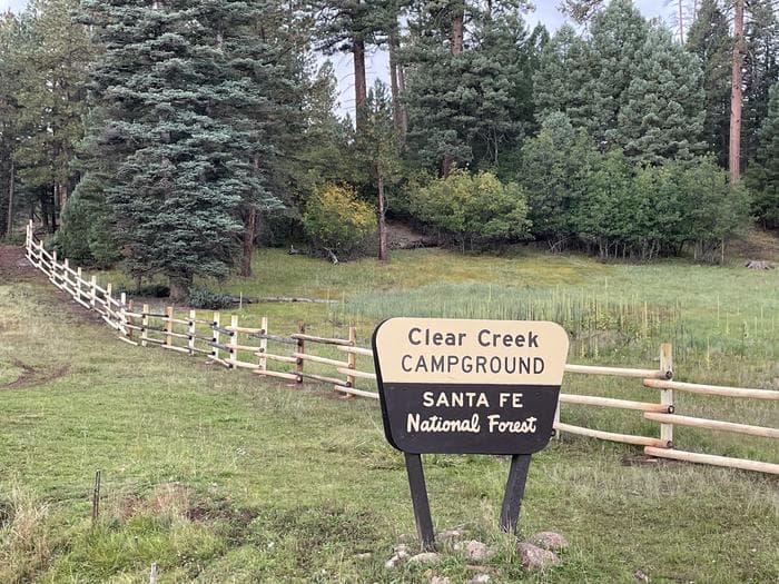
Overview Clear Creek Group Campground is less than a two hourdrive from the Albuquerque area, and provides relief from the New Mexico heat with the cool shade and refreshing air of the pines and mountains. The group campground is located in the last loop of the Clear Creek Campground, alongside the serene Clear Creek. Recreation Local streams and the San Gregorio reservoir provide fishing opportunities for anglers, and hikers will delight in the many hiking opportunities in the nearby San Pedro Parks Wilderness. Facilities Local streams and the San Gregorio reservoir provide fishing opportunities for anglers, and hikers will delight in the many hiking opportunities in the nearby San Pedro Parks Wilderness. Natural Features Evergreen ponderosa pines and Engelman spruce make up the forest around the campground, a welcome sight for those escaping the heat. The majesty of the Jemez Mountains provides amazing scenery for those inthe campground and for scenic drives through the forest. A variety of wildlife call this place home including black bears, mule deer, elk, and a plethora of bird species.
View details →
Overview Datil Well Recreation Area Campground is a scenic outdoor destination located in New Mexico, approximately 1 mile west of Datil on US Highway 60. Situated along the historic Magdalena Livestock Driveway, this campground offers visitors a unique glimpse into the area's rich cattle-driving history while providing various recreational opportunities. Facilities Campsites: 22 sites, each equipped with a shade shelter, picnic table, fire pit, and barbecue grill. Amenities: Vault toilets, potable water stations, and a small visitor center. Permitted equipment: Tent camping, vehicle camping, RV camping with power hookups (additional fees apply). Recreation Camping: Enjoy overnight stays in designated campsites. Hiking: Explore 3 miles of scenic trails through pinyon-juniper and ponderosa pine woodlands. Wildlife Viewing: Observe local wildlife in their natural habitat. Historical & Cultural Site: Discover the historic Magdalena Livestock Driveway and the water well along the trail. Picnicking: Relax at the shaded picnic areas with provided tables and grills. Nearby Attractions Experience the scenic vistas of the San Augustin Plains and learn about the region's cattle-driving history at the historic sites accessible from the campground.
View details →
Overview Coal Mine Campground is situated in the upper portion of the Cibola National Forest in west-central New Mexico. Visitors can enjoy hiking the Lobo Canyon Trail, as well as picnicking and scenic driving. Recreation The Lobo Canyon Trail begins in the campground and leads hikers access a network of trails in the area. Some trails are still under constuction. Visitors also enjoy picnicking in the surrounding area. Facilities The Lobo Canyon Trail begins in the campground and leads hikers access a network of trails in the area. Some trails are still under constuction. Visitors also enjoy picnicking in the surrounding area. Natural Features The campground is located northeast of the town of Grants at an elevation of 7,400 feet. It lies on the top of a hill, with campsites situated on gently sloping ground. A forest of mature pine, juniper and oak trees surrounds the campground. Nearby Attractions The El Malpais National Monument and Conservation Area can be accessed from various points within a short drive of the campground. Its extensive, ancient lava flow landscape and other scenic features draw tourists year-round. Points of interest within the monument and conservation area include the Northwest New Mexico Visitor Center, Sandstone Bluffs Overlook and La Ventana Natural Arch. A portion of the Continental Divide National Scenic Trail parallels the Zuni-Acoma Trail as it passes through the monument. The city of Grants is about 12 miles from the campground, offering dining and lodging options. The city also boasts a mining museum with gem and mineral displays and a self-guided tour into an underground world. Charges & Cancellations A $10.00 service charge will apply if you change or cancel your reservation. Late cancellations are subject to additional fees. For full details see NRRS Reservation Policy.
View details →
Overview At an elevation of almost 9,000 ft., campers at the Aspen Group Area can expect cool, crisp, mountain breezes coming off the steep Sacramento Mountains - perfect for an escape from the scorching desert valley below. The campground is surrounded by mixed pine, fir, and plenty of white-trunked aspen trees, with a high likelihood of blue skies above. The Sacramento Mountains overlook Dog Canyon and the Tularosa Basin. Take advantage of the campground's high elevation and revel in the breathtaking beauty of the region's unspoiled vistas stretching out over the Tularosa Basin. Wildlife in the area includes elk, deer, bears. With some luck, you could even spot a roadrunner. Recreation The campground is surrounded by a series of hiking trails. To the west you'll find trails with outstanding overlooks from Alamo Peak and Stark Peak. The most popular hike is the Osha Trail, which is a 2.5-mile loop. Facilities The campground is surrounded by a series of hiking trails. To the west you'll find trails with outstanding overlooks from Alamo Peak and Stark Peak. The most popular hike is the Osha Trail, which is a 2.5-mile loop. Natural Features Aspen is set in the rolling Sacramento Mountains of south-central New Mexico, near Alamo Peak and Stark Peak. It's part of Lincoln National Forest, most notable as the birthplace of the original Smokey Bear. Nearby Attractions The Rim Trail, a breathtaking 32-mile path for mountain biking, hiking, and horseback riding, can be reached a quarter mile from the campground. One stretch of the trail is open to motorcyclists, too. The Oliver Lee Memorial State Park, at the foot of the mountains, is worth a visit to see a restored 19th century ranch house and explore the flowering oasis of Dog Canyon.
View details →
Overview Upper Fir Group Area is one of the most popular campsites in the Sacramento Mountain area. Unique to its neighboring campgrounds, it's set far back from public roads, allowing for true peace and quiet. The campground is on the northwestern portion of the Lincoln National Forest, a protected area spanning an incredible 1.1 million acres of land. Spend your days exploring the mountains, or head west for a day trip to explore White Sands National Monument, the world's largest dune field of pure, white gypsum sand. Recreation An open meadow, perfect for sports like ultimate Frisbee or horseshoes, is connected to the campground. The Rim Trail is a short hike or drive away, offering epic views, rocky inclines, and switchbacks for adventurous mountain bikers, hikers, and horse-back riders. Further down, the same trail opens up to motorcyclists as well. Facilities An open meadow, perfect for sports like ultimate Frisbee or horseshoes, is connected to the campground. The Rim Trail is a short hike or drive away, offering epic views, rocky inclines, and switchbacks for adventurous mountain bikers, hikers, and horse-back riders. Further down, the same trail opens up to motorcyclists as well. Natural Features Set 9,000 feet above sea level in the Sacramento Mountains, Upper Fir Group Area is close to breathtaking scenic overlooks, spanning the far-reaching desert valley of the Tularosa Basin. The high-elevation region offers a mixture of pine, fir, aspen, and oak trees, with high mountain meadows full of wildflowers and blossoming plants. Nearby Attractions The campground is a mile from the town of Cloudcroft, a quaint tourist village with New Mexico's only standing railroad trestle.
View details →
Overview Just two miles from the village of Cloudcroft is this idyllic campground accommodating groups up to 90 visitors. Take advantage of the views of the Tularosa Basin or bask in the sun on the wildflower-dusted mountain meadow. A network of trails surround the campground, where you can look for deer, elk, and many types of birds. The region is part of the 1.1 million acres of Lincoln National Forest, where the original Smokey Bear was rescued as a cub from a forest fire. There's no shortage of beauty in the area, with expansive blue skies, clear nights for stargazing, and hikes to several peaks and overlooks. Attractions in the vicinity include White Sands National Monument, the Oliver Lee Memorial State Park, and the Sunspot Museum - home to the national solar observatory. Recreation Slide Group Area backs into the Rim Trail, offering epic views, rocky hills, and switchbacks. Head north on the trail for mountain biking, hiking, and horse-back riding. Head south for the part of the trail that allows motorcycles. An open meadow, perfect for sports like volleyball, corn hole, or football, is connected to the campsite. Facilities Slide Group Area backs into the Rim Trail, offering epic views, rocky hills, and switchbacks. Head north on the trail for mountain biking, hiking, and horse-back riding. Head south for the part of the trail that allows motorcycles. An open meadow, perfect for sports like volleyball, corn hole, or football, is connected to the campsite. Natural Features The campground is located on the rim of the Sacramento Mountains with a view of the Tularosa Basin. Mixed evergreen and aspens surround the 9,000 ft. elevation site. Nearby Attractions Drive along the Sunspot Scenic Byway to catch phenomenal views of the Tularosa Basin, White Sands National Monument, and colorful desert sunsets. Cloudcroft, a quaint mountain village nearby, is also worth a visit.
View details →
Overview Paliza Campground sits beneath sandstone cliffs on the Jemez Ranger District of the Santa Fe National Forest. The area is replete with culture, offering visitors a glimpse into the past. Ample recreation opportunities exist at or near the campground, which makes it a wonderful outdoor destination. Recreation Hiking, wildlife viewing and scenic drives are some of the popular activities enjoyed near the campground. Striking views of an ancient volcanic crater amid the rolling hills, can be seen from the Cerro Pelado Scenic Overlook, about 11 miles from the campground. Off-road vehicle trails and numerous hiking and mountain biking trails surround the campground. Facilities Hiking, wildlife viewing and scenic drives are some of the popular activities enjoyed near the campground. Striking views of an ancient volcanic crater amid the rolling hills, can be seen from the Cerro Pelado Scenic Overlook, about 11 miles from the campground. Off-road vehicle trails and numerous hiking and mountain biking trails surround the campground. Natural Features The newly refurbished campground sits in a forested area at the top of a hill with views of the Jemez Valley below. It was originally the site of a 1930s Civilian Convservation Corps base camp. Remnants of that camp, including log lean-to's and adirondack shelters with rock fireplaces, can be found within the campground. A small stream runs alongside the campground and sandstone cliffs on the nearby mesas provide excellent photographic and sightseeing opportunities. A small tract of private land is located north of the campground and common courtesy is appreciated. Nearby Attractions The campground is located five miles northeast of the town of Ponderosa, New Mexico, an area known for its vineyards and winery with a tasting room. The Jemez Pueblo and the Walatowa Visitor Center, both of which provide rewarding cultural experiences, are just 11 miles from the campground in the town of Jemez. The quaint community offers shopping and dining opportunities, as well as a variety of recreational opportunities.
View details →
Overview Holy Ghost Campground is tucked away in the Santa Fe National Forest, on the cusp of the breathtaking Pecos Wilderness in Holy Ghost Canyon. This group campground sits high in the canyon, with Holy Ghost Creek gently flowing alongside it. A network of trails invites hikers and horseback riders to discover the stunning landscapes of the surrounding wilderness. For more information on first-come, first-served sites, be sure to visit the Holy Ghost Campground website. Recreation Hiking and horseback riding are the most popular activities at Holy Ghost Campground. Holy Ghost Trail #283 runs along Holy Ghost Creek for 4.2 miles and connects with Winsor Trail #254, which accesses a 350-mile network of trails within the Pecos Wilderness. This includes Skyline Trail and 4 beautiful lakes (Katherine, Stewart, Johnson, and Spirit Lake). Anglers enjoy fishing along Holy Ghost Creek. Supports Rainbow and Brown Trout. Stocked regularly by New Mexico Game and Fish. Visit https://wildlife.dgf.nm.gov for a weekly stocking report and fishing regulations. Facilities Hiking and horseback riding are the most popular activities at Holy Ghost Campground. Holy Ghost Trail #283 runs along Holy Ghost Creek for 4.2 miles and connects with Winsor Trail #254, which accesses a 350-mile network of trails within the Pecos Wilderness. This includes Skyline Trail and 4 beautiful lakes (Katherine, Stewart, Johnson, and Spirit Lake). Anglers enjoy fishing along Holy Ghost Creek. Supports Rainbow and Brown Trout. Stocked regularly by New Mexico Game and Fish. Visit https://wildlife.dgf.nm.gov for a weekly stocking report and fishing regulations. Natural Features Holy Ghost Campground is nestled among a lush ponderosa pine and fir forest, right where aspen trees begin to flourish, in the Sangre de Cristo Mountains of New Mexico. During the summer, the area bursts into color with vibrant wildflowers, creating a stunning backdrop for outdoor adventures. The campground is bordered by Holy Ghost Creek, offering scenic views of both the forest and the majestic mountains. Nature lovers will delight in the diverse wildlife and variety of bird species that inhabit the surrounding area, making this a perfect spot for hiking, horseback riding, and simply taking in the beauty of the great outdoors. Nearby Attractions There are many hiking and fishing areas along the Pecos River, offering great opportunities for anglers and hikers alike. Just 50 minutes away, Pecos National Historical Park features prehistoric archaeological ruins, 19th-century ranches, and a Civil War battlefield, providing a rich glimpse into the area’s history. The town of Pecos is located about 22 miles south of the campground. 46 miles to Santa Fe. contact_info For facility specific information, please call (505) 757-6121.
View details →
Overview Jack's Creek Group Area is a picturesque, high-elevation campground situated just 50 miles from Santa Fe. Set at an altitude of approximately 8,000 feet within the Santa Fe National Forest, visitors can enjoy moderate temperatures and invigorating mountain breezes. Perfect for family reunions, recreational events, and large gatherings, it features 2 spacious group units to rent (Group A and Group B), each accommodating up to 40 guests. Open from mid-April to mid-November, this campground provides stunning views of the surrounding wilderness, making it an ideal retreat for outdoor enthusiasts. Recreation The campground's close proximity to the popular Jacks Creek Trail is an added bonus. Jacks Creek Trail #257 is 14.3 miles long, starting at Trail 25 and ending at Trail 251. This trail is best for experienced hikers and horseback riders, making it a great option for those seeking a challenge. The trail is open for hiking, backpacking, and horseback riding. A common route leads to Pecos Baldy Lake, where overnight camping is allowed, with campfires permitted 200 feet from the water. For more information about the Jacks Creek Trail and its offerings, visit the Jacks Creek Trailhead website. Fishermen can enjoy catching rainbow, brown, and cutthroat trout in Jacks Creek. Although Jacks creek is not regularly stocked, you can visit New Mexico Department of Game and Fish for weekly stocking reports and fishing regulations. Facilities The campground's close proximity to the popular Jacks Creek Trail is an added bonus. Jacks Creek Trail #257 is 14.3 miles long, starting at Trail 25 and ending at Trail 251. This trail is best for experienced hikers and horseback riders, making it a great option for those seeking a challenge. The trail is open for hiking, backpacking, and horseback riding. A common route leads to Pecos Baldy Lake, where overnight camping is allowed, with campfires permitted 200 feet from the water. For more information about the Jacks Creek Trail and its offerings, visit the Jacks Creek Trailhead website. Fishermen can enjoy catching rainbow, brown, and cutthroat trout in Jacks Creek. Although Jacks creek is not regularly stocked, you can visit New Mexico Department of Game and Fish for weekly stocking reports and fishing regulations. Natural Features Nestled in the Sangre de Cristo Mountains, the Jack's Creek Group Campground is located on the edge of the Pecos Wilderness, which encompasses 160,000 acres of mountain landscapes, high-altitude lakes, and the Pecos River. The campground is richly forested, featuring a mix of firs and aspens that showcase golden foliage in the fall. Down the road from to the group campground, Jack's Creek enhances the area’s natural beauty, creating a serene atmosphere ideal for relaxation and great trout fishing. The region teems with diverse wildlife, including elk, mule deer, and migratory birds. In winter, bald eagles and other raptors can be spotted, making Jack's Creek a great destination for nature lovers and wildlife enthusiasts alike. Nearby Attractions There are many hiking and fishing areas along the Pecos River, offering great opportunities for anglers and hikers alike. Just 50 minutes away, Pecos National Historical Park features prehistoric archaeological ruins, 19th-century ranches, and a Civil War battlefield, providing a rich glimpse into the area’s history. The town of Pecos is located about 21 miles south of the campground. The City of Santa Fe is just over an hour drive away.
View details →
Overview At 8475 feet in elevation, Black Canyon Campground is in a great location to experience some of the finest mountain scenery the Southwest has to offer. The facility is newly renovated and provides access to a variety of outdoor recreational activities. Campers can enjoy warm days and cool weather in the summer months, providing a scenic getaway from the desert heat. Recreation Hikers enjoy a pleasant hiking 1.5-mile trail that loops around the campground and into the surrounding forest. Several additional hiking, mountain biking and horseback riding trails are located nearby. The Pecos Wilderness can be accessed eight miles from the campground, with many trails leading to majestic peaks and through valleys, canyons and forested groves. Many recreation opportunities exist along Highway 475, both above and below Black Canyon Campground, including hiking and biking trails and picnic areas. In the winter, the area offers both Nordic and alpine skiing. Facilities Hikers enjoy a pleasant hiking 1.5-mile trail that loops around the campground and into the surrounding forest. Several additional hiking, mountain biking and horseback riding trails are located nearby. The Pecos Wilderness can be accessed eight miles from the campground, with many trails leading to majestic peaks and through valleys, canyons and forested groves. Many recreation opportunities exist along Highway 475, both above and below Black Canyon Campground, including hiking and biking trails and picnic areas. In the winter, the area offers both Nordic and alpine skiing. Natural Features The campground is situated in a forest of pine, aspen and fir trees. A good mix of sun and shade is found throughout the area. Many beautiful views are found in the surrounding forest. Nearby Attractions The campground is located about seven miles northeast of the town of Santa Fe, New Mexico. This unique town is known for its cultural heritage, art galleries and museums. contact_info This location has limited staffing. Please call (505) 753-7331 for general information.
View details →
Overview Lower Fir Group Area is a high-energy and highly popular group campground in the Sacramento Mountain area. The site is set away from public roads, so that outside noise is non-existent, leaving only the sweet sounds of rustling aspen leaves. The campground sits within the Lincoln National Forest, which spans 1.1 million acres of undisturbed landscape. Spend your days exploring the mountain trails, or head west for a day trip to White Sands National Monument, the world's largest dune field of pure, white gypsum sand. Bring your camera and binoculars for the chance to observe wild elk, deer, birds, and even an occasional black bear. Recreation An open meadow, ideal for activities like volleyball or horseshoes, is adjacent to the campground. The Rim Trail is a short hike or drive away, offering epic views, rocky inclines, and switchbacks for adventurous mountain bikers, hikers, and horse-back riders. A few miles south, the same trail opens up to motorcyclists as well. Facilities An open meadow, ideal for activities like volleyball or horseshoes, is adjacent to the campground. The Rim Trail is a short hike or drive away, offering epic views, rocky inclines, and switchbacks for adventurous mountain bikers, hikers, and horse-back riders. A few miles south, the same trail opens up to motorcyclists as well. Natural Features Lower Fir Group sits at a high elevation of 9,000 ft., providing visitors with dramatic views of the Tularosa Basin and lush mountain meadows surrounded by pine, fir, aspen and oak trees. Nearby Attractions The campground is a mile from the village of Cloudcroft, a quaint mountain town with New Mexico's only standing railroad trestle. Trails for ATVs are near the area, too.
View details →
Overview San Antonio Campground is adjacent to the San Antonio River, tucked into a forest of ponderosa pine at 7,600 feet above sea level. This popular campground is open from May through October in the Santa Fe National Forest. Visitors should be prepared for hot summer days and cool nights. San Antonio Campground was completely rebuilt and reopened in August 2010. It is designated as a reduced impact and recycle campground. Recreation A paved walking trail along the river provides access for fishing. Anglers can fish for rainbow trout. Visitors enjoy wading in the river on hot summer days. The campground offers easy driving access to several recreational sites nearby, including the popular La Cueva Picnic Site, Spence Hot Spring Trailhead, Battleship Rock Trailhead and a couple of fishing sites along the San Antonio River. Facilities A paved walking trail along the river provides access for fishing. Anglers can fish for rainbow trout. Visitors enjoy wading in the river on hot summer days. The campground offers easy driving access to several recreational sites nearby, including the popular La Cueva Picnic Site, Spence Hot Spring Trailhead, Battleship Rock Trailhead and a couple of fishing sites along the San Antonio River. Natural Features Some of the finest mountain scenery in the Southwest is found in the 1.6 million acres within the Santa Fe National Forest. Elevations range from 5,300 to 13,103 feet at the summit of Truchas Peak, located within the Pecos Wilderness. The diverse ecosystems of the Santa Fe National Forest are home to a variety of wildlife species. The ponderosa pine forests at 6,000-9,500 feet provide habitat for the Jemez Mountain salamander, northern goshawk, Merriam's turkey, Abert's squirrel and hairy woodpecker. Nearby Attractions The 163-mile Jemez Mountain Trail Scenic Byway passes amazing geological formations, ancient Indian ruins and an Indian pueblo. The area is rich in logging, mining and ranching heritage.
View details →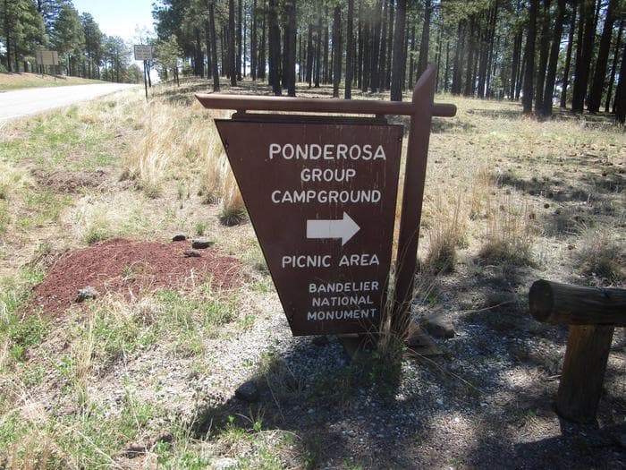
Overview ***Ponderosa Group Campground will be closed starting November 1, 2024 while the park works to complete a major water line replacement/improvement project. The closure is anticipated to last several months.*** Ponderosa Group Campground is located 6 miles (9.7 km) from the park's main entrance and is an ideal place to stay for large groups visiting Bandelier National Monument. The campground is adjacent to Ponderosa Trailhead providing access to more than 70 miles (113 km) of hiking trails and is just a short drive from the Visitor Center, the Frijoles Canyon Shuttle System (mid-May to mid-October), and the town of Los Alamos, Valles Caldera National Preserve, Manhattan Project National Historic Site, and the Santa Fe National Forest. Ponderosa Group Campground is open year-round (water is only available from mid-May to mid-October). Same-day reservations are not permitted. Frijoles Canyon and the park Visitor Center are accessible only by shuttle bus from mid-May to mid-October. The shuttle bus system stops at the Bandelier Visitor Center, Juniper Campground, and the White Rock Visitor Center in the town of White Rock. Outside of the designated shuttle bus period, visitors may access all park areas by private vehicle. Public events are prohibited at Ponderosa Campground. Private events that adhere to campsite capacity limits, may be permitted after obtaining a special use permit. Visit the park's Permits & Reservations web page or call (505) 672-3861 ext. 1102. Recreation Accessible from Ponderosa Group Campground, the Ponderosa Trail descends into the park through ponderosa pine forest and connects to many other trails including the Middle Frijoles Trails which leads 8 miles (13 km) through Frijoles Canyon to the Visitor Center and Main Loop Trail. The Visitor Center houses museum exhibits, park film, information and ranger programs, Western National Parks Association sales outlet, and more. Entrance to Frijoles Canyon and the Visitor Center is by shuttle bus only from mid-May to mid-October. These areas are accesibile by private vehicle outside the shuttle bus period. Although rock climbing is prohibited within Bandelier National Monument, many popular climbs are within a short drive up Route 4 into the Jemez Mountains. Facilities Accessible from Ponderosa Group Campground, the Ponderosa Trail descends into the park through ponderosa pine forest and connects to many other trails including the Middle Frijoles Trails which leads 8 miles (13 km) through Frijoles Canyon to the Visitor Center and Main Loop Trail. The Visitor Center houses museum exhibits, park film, information and ranger programs, Western National Parks Association sales outlet, and more. Entrance to Frijoles Canyon and the Visitor Center is by shuttle bus only from mid-May to mid-October. These areas are accesibile by private vehicle outside the shuttle bus period. Although rock climbing is prohibited within Bandelier National Monument, many popular climbs are within a short drive up Route 4 into the Jemez Mountains. Natural Features Bandelier National Monument protects over 33,000 acres (13,355 ha) of rugged, beautiful canyon and mesa country which features evidence of human presence going back over 11,000 years. Petroglyphs, dwellings carved into the soft rock cliffs, and standing masonry walls pay tribute to the early days of a culture that still survives in the surrounding communities. Bandelier National Monument sits at the southern end of the Pajarito (Spanish for "little bird") Plateau. The plateau was formed by two eruptions 1.6 and 1.4 million years ago. Home to the Bandelier Wilderness, Bandelier ranges from 5340 feet (1628 m) at the Rio Grande River to the south and 10,199 feet (3109 m) at the summit of Cerro Grande to the north, almost a mile (1.6 km) of elevation change in just under 12 miles (19 km). This elevation gradient creates a unique diversity of habitats specific to Northern New Mexico. The diversity of habitats and quick access to water supported a relatively large population of Ancestral Pueblo people. Currently, Piñon-Juniper woodlands dominate in the southern parts of the park transitioning through ponderosa pine savannahs and forests, finally reaching mixed conifer forests at the highest elevation. Scattered throughout the park are desert grasslands, montane meadows, and riparian areas in the canyon bottoms. Over 70 miles (113 km) of trails at Bandelier climb in and out of deep canyons and cross large flat mesas, showcasing the entire spectrum of volcanic geology and ecosystems found within the park. The park is home to over 55 species of mammals including mule deer, Abert's squirrels, mountain lions, black bears, and 16 species of bats. Reptiles and amphibians of all shapes and sizes can be seen. Birds such as Steller's jays, canyon towhees and mountain chickadees stay year-round, whereas turkey vultures, western tanagers, and black-headed grosbeaks are summer residents. Nearby Attractions The town of Los Alamos has shopping, museums, amenities, a movie theater, ice rink, ski hill, and is home to the Los Alamos unit of Manhattan Project National Historic Site. Nearby Department of Energy and US Forest Service lands provide trails which accommodate pets. Valles Caldera National Preserve is 16 miles (26 km) west of Bandelier. Jemez Historic Site is 37 miles (60 km) west. Pecos National Historical Park is 70 miles (113 km) southeast. Santa Fe, 40 miles (64 km) south of the park, is home to the New Mexico state capitol, museums, historic districts, art galleries, food, accomodations, and more.
View details →
Overview Juniper Family Campground is the ideal place to camp on the Pajarito Plateau. Located just inside the main park entrance, the campground is a short drive from the Bandelier Visitor Center, the Frijoles Canyon Shuttle bus system (mid-May to mid-October), and the adjacent towns of Los Alamos and White Rock. Juniper Family Campground is the perfect "home base" to explore the Pajarito Plateau, Jemez Mountains, and all of north central New Mexico! The campground is divided into 3 loops: Abert's Squirrel Loop (Loop A) campsites are available year-round as first-come, first serve only. Pay for first-come, first-serve campsites at the self-pay kiosk located at the Juniper Family Campground or in-person at the Bandelier Visitor Center during business hours. Black Bear Loop (Loop B) campsites are open year-round and are reservable up to 6 months in advance. Some sites may open on shorter booking windows (7 or 14 days in advance or the day of arrival). Coyote Loop (Loop C) campsites are open seasonally, March 1 – October 31, and are reservable up to 6 months in advance. Some sites may open on shorter booking windows (7 or 14 days in advance). You may also book campsite reservations in Loops B & C on the day of arrival (subject to availability). HOWEVER, cell service/data is not always reliable in the park and no public WiFi is available. The park highly recommends booking your reservation from the neighboring towns of Los Alamos and White Rock before heading to Bandelier. Group campsites (in Loop A) are available by reservation only up to 12 months in advance until the day before arrival (subject to availability). Same day reservations are not available for group campsites. Recreation Bandelier is home to over 70 miles (113 km) of hiking trails most of which are located within federally designated wilderness. Two trails are accessible directly from Juniper Family Campground. The Frey Trail follows the historic route into Frijoles Canyon and descends down the canyon wall to the Visitor Center and the Main Loop Trail. The Tyuonyi Overlook Trail leaves the amphitheater parking area for a 3/4-mile (1.2 km) hike across the open mesa top to an overlook providing breathtaking views of Frijoles Canyon and of Tyounyi, an ancestral Pueblo village. The Bandelier Visitor Center houses museum exhibits, park film, information and ranger programs, Western National Parks Association sales outlet, and more. Entrance to Frijoles Canyon and the Visitor Center is by shuttle bus only (or by hiking) from mid-May to mid-October. These areas are accesibile by private vehicle outside the shuttle bus period. Many other opportunities for recreation and exploring the history and culture of the area are nearby, such as Valles Caldera National Preserve, Manhattan Project National Historical Park, Los Alamos museums, the Jemez District of the Santa Fe National Forest, US Department of Energy public recreation trails, and others around Los Alamos County. Rock climbing is prohibited within Bandelier National Monument, however many popular climbs are within a short drive up Route 4 into the Jemez Mountains. Facilities Bandelier is home to over 70 miles (113 km) of hiking trails most of which are located within federally designated wilderness. Two trails are accessible directly from Juniper Family Campground. The Frey Trail follows the historic route into Frijoles Canyon and descends down the canyon wall to the Visitor Center and the Main Loop Trail. The Tyuonyi Overlook Trail leaves the amphitheater parking area for a 3/4-mile (1.2 km) hike across the open mesa top to an overlook providing breathtaking views of Frijoles Canyon and of Tyounyi, an ancestral Pueblo village. The Bandelier Visitor Center houses museum exhibits, park film, information and ranger programs, Western National Parks Association sales outlet, and more. Entrance to Frijoles Canyon and the Visitor Center is by shuttle bus only (or by hiking) from mid-May to mid-October. These areas are accesibile by private vehicle outside the shuttle bus period. Many other opportunities for recreation and exploring the history and culture of the area are nearby, such as Valles Caldera National Preserve, Manhattan Project National Historical Park, Los Alamos museums, the Jemez District of the Santa Fe National Forest, US Department of Energy public recreation trails, and others around Los Alamos County. Rock climbing is prohibited within Bandelier National Monument, however many popular climbs are within a short drive up Route 4 into the Jemez Mountains. Natural Features Bandelier National Monument protects over 33,000 acres (13355 ha) of rugged, beautiful canyon and mesa country which features evidence of human presence going back over 11,000 years. Petroglyphs, dwellings carved into the soft rock cliffs, and standing masonry walls pay tribute to the early days of a culture that still survives in the surrounding communities. Bandelier National Monument sits at the southern end of the Pajarito (Spanish for little bird) Plateau. The plateau was formed by two eruptions 1.6 and 1.4 million years ago. Home to the Bandelier Wilderness, Bandelier ranges from 5340 ft (1628 m) at the Rio Grande River to the south and 10,199 ft (3109 m) at the summit of Cerro Grande to the north, almost a mile of elevation change in just under 12 miles (19 km). This elevation gradient creates a unique diversity of habitats specific to Northern New Mexico. The diversity of habitats and quick access to water supported a relatively large population of Ancestral Pueblo people. Currently, Piñon-Juniper woodlands dominate in the southern parts of the park transitioning through ponderosa pine savannahs and forests, finally reaching mixed conifer forests at the highest elevation. Scattered throughout the park are desert grasslands, montane meadows, and riparian areas in the canyon bottoms. Over 70 miles (113 km) of trails at Bandelier climb in and out of deep canyons and cross large flat mesas, showcasing the entire spectrum of volcanic geology and ecosystems found within the park. The park is home to over 55 species of mammals including mule deer, Abert's squirrels, mountain lions, black bears, and 16 species of bats. Reptiles and amphibians of all shapes and sizes can be seen. Birds such as Steller's jays, canyon towhees and mountain chickadees stay year-round, whereas turkey vultures, western tanagers, and black-headed grosbeaks are summer residents. Nearby Attractions The town of Los Alamos has shopping, museums, amenities, a movie theater, ice rink, ski hill, and is home to Manhattan Project National Historic Site. Nearby Department of Energy and US Forest Service lands provide trails which accommodate pets. Valles Caldera National Preserve is 16 miles (26 km) west of Bandelier. Jemez Historic Site is 37 miles (60 km) west. Pecos National Historical Park is 70 miles (113 km) southeast. Santa Fe, 40 miles (64 km) south of the park, is home to the New Mexico state capitol, museums, historic districts, art galleries, food, accomodations, and more. contact_info This location is unstaffed. To speak with our main office for general information, please call: (505) 672-3861.
View details →
Overview Cochiti Recreation Area is located in Sandoval County, New Mexico, within the boundaries of the Pueblo de Cochiti Indian Reservation. The lake offers two public recreation areas: Cochiti on the west side of the lake and Tetilla Peak on the east side. Both sides offer spectacular scenic views of the water and surrounding mountains. The Cochiti Dam is one of the ten largest earth-fill dams in the United States, and also one of the largest in the world. The lake derives its name from the Indian Pueblo on the Cochiti Reservation. Recreation Our quiet lake is an ideal location for all paddle, wind surfing, and sailing craft. The lake is also a popular fishing spot for species such as bass, crappie, walleye, pike, catfish, sunfish and trout. Cochiti Recreation Area has a popular, family friendly, swim beach Day Use area for public enjoyment. It is a fee area, $5 per vehicle, but the cost is covered by the campsite fee for visitors staying in the campground. Additionally, the Cochiti picnic area has 21 covered picnic sites with a large group site that can be reserved by calling the main office. Cochiti Day Use Areas are open from April 15th to October 15th. Facilities Our quiet lake is an ideal location for all paddle, wind surfing, and sailing craft. The lake is also a popular fishing spot for species such as bass, crappie, walleye, pike, catfish, sunfish and trout. Cochiti Recreation Area has a popular, family friendly, swim beach Day Use area for public enjoyment. It is a fee area, $5 per vehicle, but the cost is covered by the campsite fee for visitors staying in the campground. Additionally, the Cochiti picnic area has 21 covered picnic sites with a large group site that can be reserved by calling the main office. Cochiti Day Use Areas are open from April 15th to October 15th. Natural Features Cochiti Lake sits at 5,343ft in elevation and is nestled in the foothills of the Jemez Mountains. Our high desert environment is dominated by juniper, pinon trees, and mixed grasslands. There are many opportunities for wildlife viewing. Four osprey nesting platforms have been erected around the lake to provide nesting sites, as well as viewing opportunities. On the east side of the lake, deer, coyote, river otters, rabbits, beavers, and the occasional bear are often sighted. Nearby Attractions Cochiti Lake is five miles from Tent Rocks National Monument, which has fascinating geological formations.
View details →
Overview Riana Campground is located on a 150 ft. bluff overlooking the scenic Abiquiu Lake in northern New Mexico, just one hour northwest of charming Santa Fe. The lake sits at an elevation of 6,400 feet on the Rio Chama, a tributary of the legendary Rio Grande. Recreation Abiquiu Lake offers many opportunities for outdoor recreation. The fishing here is some of the finest in northern New Mexico. Visitors enjoy boating, water skiing, and hiking. Lake shore access for boat launching is 1 mile from the campground. Facilities Abiquiu Lake offers many opportunities for outdoor recreation. The fishing here is some of the finest in northern New Mexico. Visitors enjoy boating, water skiing, and hiking. Lake shore access for boat launching is 1 mile from the campground. Natural Features Fragrant Pinion pine, juniper, and sage cover the campsite, providing a distinct smell of northern New Mexico, but offering limited shade. Colorful rock formations surround the park. Visitors are awarded a panoramic view of the narrow mesa, Cerro Pedernal, locally known as "Pedernal." Famous American painter, Georgia O'Keefe, had her ashes scattered over its top. contact_info For facility specific information, please call (505) 685-4561. Nearby Attractions Northern New Mexico is full of beauty and history. The educational and historical Ghost Ranch is about 10 minutes from the park. The Georgia O'Keeffe Museum, San Pedro Wilderness, Cumbres Toltec Railroad, Chaco Canyon, and Bandelier National Monument are all nearby. The ski-town of Taos is just over an hour away, and colorful Santa Fe is an hour southeast, both with restaurants, shops, and museums.
View details →
Overview Located on the outskirts of Ruidoso, Cedar Creek provides a wonderful space for groups visiting for the day or staying overnight. With a picnic shelter and three group campsites, the recreation area is ideal for an outing in Lincoln National Forest. A popular pastime is is hiking and mountain biking along the scenic multi-use trails adjacent to the Sam Tobias Memorial Group Campground. There are opporunities to see a number of different wildlife, including Mule deer and Elk in the area. Recreation Hiking and biking are among the most popular activities here, with options like the T90 fitness Trail which extends 1.3 miles and includes exercise stations. Bilking trails T120 A-D and T121 A& B are also nearby. Also we have an expert-only downhill mountain bike trail, located near the water tower to the east of the Campgrounds. The trail ends at the picnic area. Dogs must be kept on leash at all times while hiking. Dogs are not allowed on the Fitness trail. Facilities Hiking and biking are among the most popular activities here, with options like the T90 fitness Trail which extends 1.3 miles and includes exercise stations. Bilking trails T120 A-D and T121 A& B are also nearby. Also we have an expert-only downhill mountain bike trail, located near the water tower to the east of the Campgrounds. The trail ends at the picnic area. Dogs must be kept on leash at all times while hiking. Dogs are not allowed on the Fitness trail. Natural Features Cedar Creek is perched along its namesake, Cedar Creek at a 7,000 foot elevation. Lincoln National Forest, located in south-central New Mexico, is most notable as the birthplace of the original Smokey Bear. Nearby Attractions Ruidoso is a delightful town with quaint shops, restaurants and art galleries. If picnickers wish to camp overnight, they can head to Sam Tobias Memorial Group Campground.
View details →
Overview Gallo Campground is located within Chaco Culture National Historical Park. Tucked among the fallen boulders and cliffs of Gallo Wash, the campground offers camping in a rugged environment, surrounded by petroglyphs, a cliff dwelling, inscriptions and a high desert landscape. The area is remote with no services. Please be prepared with plenty of food, water, shade, sunscreen and cold weather necessities. Traveling to Chaco Two roads access Chaco Culture National Historical Park. From the north, Road 7900 turns off of US Hwy 550/44 three miles east of Nageezi and fifty miles west of Cuba. Continue on Road 7900 for five paved miles then turn right onto Road 7950 where the payment will continue for several miles. The rest of the sixteen miles are unpaved. From the south, turn north onto NM Rt. 57 for twenty miles of rough unpaved road. When the unpaved roads are wet (rain, snow, etc.) they can be difficlut to traverse and vehicles can become stuck in thick mud or slide off the slippery road. Please keep in mind that there is no phone service and it is sometimes difficult to get tow service along these roads. Please contact us at 505 786-7014 for the latest road conditions. Marijuana on Federal Lands Posted: May 27, 2022 With the legalization of marijuana in the State of New Mexico, Chaco Culture National Historical Park would like to provide clarification regarding the use and possession of marijuana on Federal lands. The recently passed New Mexico State law, which allows for limited recreational marijuana use under certain conditions, has no bearing on Federal laws which continue to identify marijuana as a Schedule I illegal drug, and prohibit its use. Possession of marijuana or use of any amount of marijuana is still prohibited in Chaco Culture National Historical Park, its facilities, concessions, and campgrounds. Recreation The Visitor Center is located one mile from the Gallo Campground which offers a staffed information desk. There is an additional charge for Park entry separate from the camping fees. All campers are required to pay entrance fee at the Visitor Center or present a vaild pass. The Visitor Center offers a brief introductory information, a 25-minute introductory video and a bookstore with many selections of educational materials, books and gift items. After checking in at the Visitor Center, one can drive the canyon loop road where there are six front country and our backcountry hiking trails that lead to ancient cultural sites. Facilities The Visitor Center is located one mile from the Gallo Campground which offers a staffed information desk. There is an additional charge for Park entry separate from the camping fees. All campers are required to pay entrance fee at the Visitor Center or present a vaild pass. The Visitor Center offers a brief introductory information, a 25-minute introductory video and a bookstore with many selections of educational materials, books and gift items. After checking in at the Visitor Center, one can drive the canyon loop road where there are six front country and our backcountry hiking trails that lead to ancient cultural sites. Natural Features Gallo Campground is located in a lowland desert surrounded by canyon walls, arroyos and wash with plenty of southwestern desert plants and brushes, but there are no trees. Nearby Attractions Chaco Culture National Historical Park is isolated from various towns and cities. Within two to three hour drive, there are some attractions such as Aztec Ruins, Salmon Ruins, Mesa Verde National Park, El Malpais National Monument, El Morro National Monument, Canyon De Chelly National Monument, Four Corners Monument, Navajo Nation Headquarters and Museum in Window Rock, Arizona.
View details →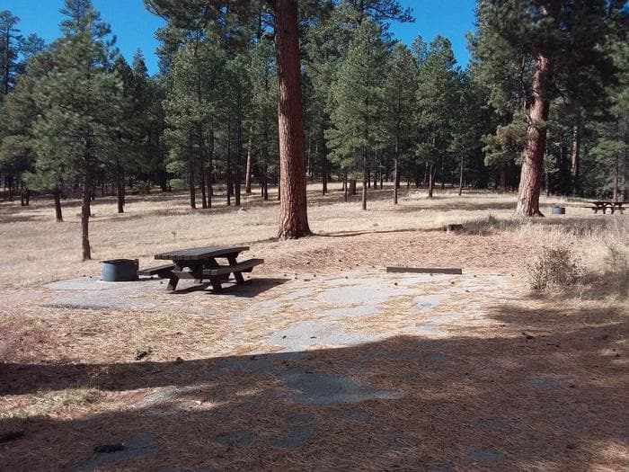
Overview Less than two hours from the city of Albuquerque, Rio de las Vacas Campground offers a cool oasis from the New Mexico heat. Visitors delight in the hiking and fishing opportunities available in the shade of the pine covered Jemez Mountains. A few of the campsites have the creek running along them, providing a soothing atmosphere for campers. Recreation Local streams and the San Gregorio reservoir provide fishing opportunities for anglers, and hikers will delight in the many hiking opportunities in the nearby San Pedro Parks Wilderness. Facilities Local streams and the San Gregorio reservoir provide fishing opportunities for anglers, and hikers will delight in the many hiking opportunities in the nearby San Pedro Parks Wilderness. Natural Features The campground is located amid stunning ponderosa pines in close proximity to the Rio de las Vacas. The campground has a beautiful open meadow and scenic views of the surrounding Jemez Mountains. Fall brings migrating birds through the campground and the sounds of elk bugling to impress potential mates. Nearby Attractions The San Pedro Parks Wilderness, just north of the Rio de las Vacas Campground, offers easy and scenic day hikes. The minimal grade increases of the trails into the San Pedro Parks make this wilderness an ideal backpacking destination for beginners and experienced backpackers alike. Three main trailheads, the San Gregorio, Palomas and Los Pinos, are within driving distance of the campground.
View details →
Overview Please note that Field Tract Campground is currently closed until further notice due to necessary repairs on the shelters. We appreciate your understanding and patience as we work to restore the facilities. Field Tract Campground is located on the banks of the beautiful Pecos River. The campground is 10 miles north of the village of Pecos. Visitors enjoy Field Tract for its family friendly atmosphere, fishing and access to the Santa Fe National Forest. Recreation Field Tract Campground offers excellent fishing access on the Pecos River. There are nearby picnicking sites with changes in scenery. There are multiple trails found in the canyon as well. Facilities Field Tract Campground offers excellent fishing access on the Pecos River. There are nearby picnicking sites with changes in scenery. There are multiple trails found in the canyon as well. Natural Features Situated on the Pecos River, Field Tract Campground provides an inviting forested setting. The Sangre De Cristo Mountains surround the Pecos Canyon and provide magnificent opportunities for wildlife viewing. Bald eagles migrate through the winter, and can be seen soaring throughout the canyon. Nearby Attractions Field Tract Campground offers direct access to the Pecos River and there are many terrific fishing opportunities nearby. There are also trailheads providing access to the Pecos Wilderness as well as climbing opportunities within 10 miles.
View details →
Overview NOT CURRENTLY ACCEPTING RESERVATIONS On February 2, 1912, Aldo Leopold (1887–1948) wrote to his fiancée, Estella Bergère, in Santa Fe that the Forest Service had appropriated $650 to build a new supervisor’s quarters he had designed at Tres Piedras, New Mexico, northwest of Taos. At the time, Leopold was about to become the new Forest Supervisor of the Carson National Forest in Tres Piedras. Later that year, he built the house, which the newly married couple decided to call “Mi Casita”. Leopold was transferred to Tres Piedras from the Apache National Forest in Arizona in 1911. It was here that he started to formulate his land ethic that would find its way into his classic, Sand County Almanac. He started to see land holistically and to recognize that this perspective was essential to its wise management. Today we call this ecosystem management. Aldo Leopold is considered by many to be the father of wildlife ecology. The Aldo Leopold House offers exceptional three-season access and opportunities in this historic home only ½ hr. west of Taos, New Mexico. The home is a Craftsman Style Bungalow and was restored by Historicorps and the Carson NF in 2005. This full-amenity house accommodates up to 8 people: two queen beds and 6 twins. Guests are responsible for their own safety and certain necessities (see below). The house is located in a rural area of Northern New Mexico. There is very limited cell phone service and the nearest gas station is located in Antonito, Colorado. (30 miles north) Recreation The cabin is adjacent to one of the Tres Piedras (three rocks, aka the TP Rocks), which are composed of “excellent granite” and offer great non-technical hiking and scrambling opportunities as well as difficult technical climbing routes. One can access the Carson NF directly behind the house. The Aldo Leopold Trail can be accessed proximate the Tres Piedras RD just to the north off Hwy 64. Surrounded by pine trees, a stay at the Aldo Leopold House will take you back to a simpler time. Facilities The Leopold house is approximately 1300 Sq. Ft. There is a dining room with a large table and chairs. The home has four bedrooms with beds for up to 8 people. The house has a fully equipped kitchen, and a large covered front porch, and a back porch with a picnic table. There is a gas range, oven, microwave, fully equipped kitchen, indoor plumbing, flush toilet, and claw foot bathtub/shower. There is only one bathroom in the home. The fireplace is not for use. Parking is available on site and can accommodate approximately 8 vehicles. No RVs or tent camping is allowed. Guests will need to provide sleeping bags/linens, towels, toilet paper, paper towels, coffee, hand soap, and dish soap, etc. This is a non-smoking facility. Natural Features The cabin was built in the shadow of one the “TP Rocks” and the front porch faces eastward across the great sage plain and the Rio Grande Gorge toward Wheeler Peak (New Mexico’s highest) and the Sangre de Christo Range. contact_info For facility specific information, please call (575) 779-1895. Nearby Attractions The Leopold House is located on the Tres Piedras Ranger District office compound. From the house visitors have access to a variety of activities on the forest. Hopewell Lake campground and day use area is approximately 30 miles from the house (north on Hwy 64) and offers opportunities for fishing, hiking on the Continental Divide National Scenic Trail, or exploring many roads in the San Juan Mountains. The Cruces Basin wilderness is approximately 25 miles west of the house and has amazing opportunities for solitude. The town of Taos is 30 miles to the east. Taos Pueblo National Heritage site is located a few miles north of the Town of Taos. Ojo Caliente Mineral Springs is located 60 miles south of the house. Between the house and the Town of Taos lies the Rio Grande del Norte National Monument. There are opportunities to ride the Cumbres and Toltec Scenic Railroad, riders can board the train in Chama NM or Antonito CO.
View details →
Overview Jemez Falls Campground is located in a stunning Ponderosa Pine and forest meadow environment. The campground elevation is 7,880 feet above sea level. Come prepared for warm days and cool nights. The Cerro Pelado Area closure prohibits members of the public from entering Trail 137 from access points South of the East Fork Trailhead. Entry is allowed North from the East Fork Trailhead to Las Conchas Trailhead. Please remember that this campground is special. Help keep it clean and beautiful by using the trash dumpsters. Campground has 52 camp sites with picnic table and fire ring. Paved access which allows trailers and RV's up to 40 feet. For the 2022 Season of Use, loop 4 sites are non-generator use areas. Loops 1-3 may use generators from 6:00 AM to 10:00 PM. There is paved access from the highway and paved internal roads to individual campsites. There are no RV hook-ups. Drinking water is provided from spigots conveniently located throughout the campground. Vault toilets provide basic sanitation needs. A campground host is on duty. Recreation Overnight camping, fishing, and hiking are main attractions. Other recreational activities include outdoor photography and nature viewing. The campground is within the heart of the Jemez National Recreation Area. Facilities Overnight camping, fishing, and hiking are main attractions. Other recreational activities include outdoor photography and nature viewing. The campground is within the heart of the Jemez National Recreation Area. Natural Features The East Fork Jemez Wild and Scenic River runs close to the campground. The campground is situated on rolling terrain shaded by pines and sunny in open meadows. Nearby Attractions Jemez Falls, the largest waterfall in the Jemez Mountains, is a half mile hike from the campground. The Valles Caldera National Preserve and Bandelier National Monument are within short driving distance along the Jemez Mountain Trail National Scenic Byway. Charges & Cancellations
View details →FAQ
Camping in New Mexico
How many campgrounds are listed in New Mexico?
TheCampVerse currently lists 24 campgrounds in New Mexico.
What campground types are most common in New Mexico?
The most common campground types are Campground.
How can I compare campgrounds in New Mexico?
Use the campground cards and featured links on this page to compare descriptions, amenities, and details before opening each campground profile.
Keep exploring