
—
Total Campsites
Campground
—
Reservable Sites
Check by phone
—
Accessible
ADA-compliant sites
Organization
Overview
About JUNIPER LAKE GROUP
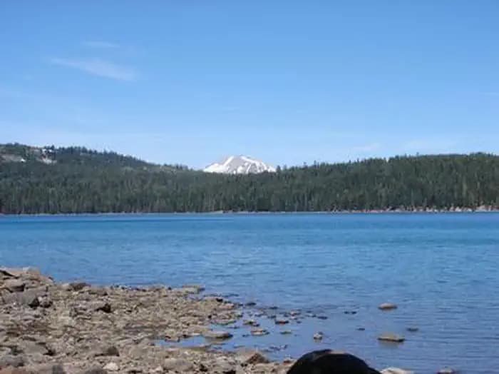
Overview Juniper Lake Group Campground (elevation 6,800 feet) is a remote, rustic facility in the southeastern part of Lassen Volcanic National Park. It is on the eastern shore of Juniper Lake, a popular swimming spot, and offers a fantastic view of Lassen Peak, the largest volcano in the park, towering at 10,457 feet. Recreation The main trailheads for Horseshoe Lake, Snag Lake and the interior of the park are within the facility. The Mount Harkness Trail ascends to a historic fire tower that is still in use. Juniper Lake is popular for canoeing, kayaking and swimming; Motorized boating is not permitted. Facilities The main trailheads for Horseshoe Lake, Snag Lake and the interior of the park are within the facility. The Mount Harkness Trail ascends to a historic fire tower that is still in use. Juniper Lake is popular for canoeing, kayaking and swimming; Motorized boating is not permitted. Natural Features The national park is known for its volcanic history, as well as its diversity of plants and animals. It contains 300 active volcanic domes and many hydrothermal features, such as mud pots and steam vents, some of which are close to the campground. Lassen Peak is the southernmost active volcano in the Cascades, and the second-most recent volcano to erupt in the lower 48 of the United States before Mount Saint Helens in 1980. Lassen National Park boasts over 700 species of flowering plants and 250 species of vertebrates, including birds, mammals, reptiles and fish. The park is at the junction of the Cascade Mountains, the Sierra Nevada Mountains and the Great Basin, thus providing many unique habitats.
- Map coordinates are available for trip planning.

Reservations & Contact
Plan your stay
Phone
530 595-6121
Michelle_DUlisse@nps.gov
Getting There
From the Red Bluff (I.5), drive east on state HWY 36 approximately 70 miles to Chester. Turn left at fire station immediately after crossing Feather River Bridge (watch for National Park Service sign on right) continue approximately 13 miles follow signs to Juniper Lake Campground and Group Campsite Area. Campground access is via paved and dirt road, last 6 miles is narrow, rough and dusty dirt road.
FAQ
Common questions
Everything you need to know before your trip to JUNIPER LAKE GROUP.
How do reservations work for JUNIPER LAKE GROUP?
Reservation availability for JUNIPER LAKE GROUP can vary by season and campsite type. Check the contact and access section before booking.
What campsite types are available at JUNIPER LAKE GROUP?
Campsite type details are limited right now. Check back as this listing is enriched.
Where is JUNIPER LAKE GROUP located?
JUNIPER LAKE GROUP is in California near MINERAL. Coordinates: 40.4511, -121.2958.
Keep Exploring