
Campgrounds in Texas
Discover diverse camping experiences from desert to pine forests in the Lone Star State
72
Campgrounds listed
100%
With photos
100%
Detailed descriptions
Campground
Top campground type
Highlights
Featured campgrounds in Texas
Explore by campground name letter
Jump to A-Z landing hubs for stronger discovery paths beyond Texas.
All campgrounds
Showing 72 campgrounds
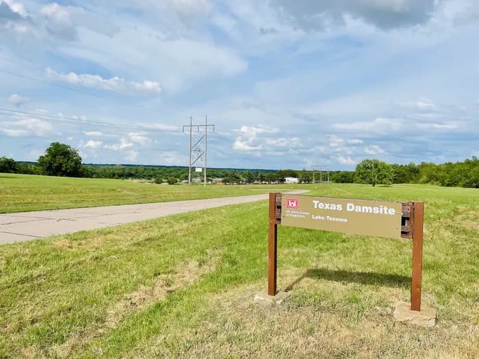
Overview Damsite Texas is a relatively small campground which consists of a total of 19 campsites. Each of the campsites do have water and electric. The campground is located right along the Red River which gives easy access to popular outdoor activities like fishing. Most of all the campsites are covered by pecan trees within the campground which allows for great shade during the summer time. Before the enterance to the camground you will notice there are multiple picnic tables and a pavillion to be able to utilize for the day, this allows visitors to spend the day along the Red River and enjoy the scenary while not having to pay the cost for overnight camping within the campground. If a visitor does choose to bring a boat to explore lake Texoma, there is a popular spillway boat ramp area that is located at the Denison dam. Recreation Even though the Damsite Texas campground is located along the Red River, Lake Texoma is located just right on the other side of the Dension Dam. Lake Texoma is a large reservoir with an excellent fishery and many access points. Boating, swimming, water skiing, hunting, birding and relaxing on the sandy beaches are the typical pursuits of most visitors. The lake is known as the "Striper Capital of the World," one of the few reservoirs in the nation where Striped bass reproduce naturally. Other popular species include largemouth and smallmouth bass, white bass, hybrid striped bass, white crappie, black crappie, channel catfish and blue catfish. Many visitors fish in the Red River in which they catch a vaiety of differnt species like Striped Bass, Blue Catfish, Channel Catfish, Alligator Gar, and occasionally American Paddlefish. Facilities Even though the Damsite Texas campground is located along the Red River, Lake Texoma is located just right on the other side of the Dension Dam. Lake Texoma is a large reservoir with an excellent fishery and many access points. Boating, swimming, water skiing, hunting, birding and relaxing on the sandy beaches are the typical pursuits of most visitors. The lake is known as the "Striper Capital of the World," one of the few reservoirs in the nation where Striped bass reproduce naturally. Other popular species include largemouth and smallmouth bass, white bass, hybrid striped bass, white crappie, black crappie, channel catfish and blue catfish. Many visitors fish in the Red River in which they catch a vaiety of differnt species like Striped Bass, Blue Catfish, Channel Catfish, Alligator Gar, and occasionally American Paddlefish. Natural Features The campground is situated right along the Texas side of the Red River by the Denison Dam. Deer, turkeys, bobcats, hawks, waterfowl and songbirds are abundant around the river. Nearby Attractions Lake Texoma features two wildlife refuges, two state parks and 23 commercial concession areas dedicated to the enjoyment of over six million visitors annually.
View details →
Overview Pat Mayse East Campground is on the banks of Pat Mayse Lake in the Red River Basin in Lamar County, Texas. Easy access to developed park areas has made the lake a haven for families who enjoy camping, picnicking, swimming, boating, fishing and other outdoor recreation. Recreation The lake provides excellent opportunities for boating, swimming and fishing. Anglers fish for largemouth bass, white crappie, sunfish, striped bass and channel and flathead catfish, among other species. Hunting is a very popular activity in the area. The surrounding lands are managed for upland game and whitetail deer. Other species present include fox squirrel, gray squirrel, bobwhite quail, mourning dove, cottontail rabbit, raccoon and fox. Opossum, beaver, mink, skunk and nutria are also present. The lake also provides resting and feeding habitat for migratory waterfowl. A few miles north of the project area are the famed Red River Bottoms where waterfowl congregate in impressive numbers. Equestrian trails are available right next to the campground. Facilities The lake provides excellent opportunities for boating, swimming and fishing. Anglers fish for largemouth bass, white crappie, sunfish, striped bass and channel and flathead catfish, among other species. Hunting is a very popular activity in the area. The surrounding lands are managed for upland game and whitetail deer. Other species present include fox squirrel, gray squirrel, bobwhite quail, mourning dove, cottontail rabbit, raccoon and fox. Opossum, beaver, mink, skunk and nutria are also present. The lake also provides resting and feeding habitat for migratory waterfowl. A few miles north of the project area are the famed Red River Bottoms where waterfowl congregate in impressive numbers. Equestrian trails are available right next to the campground. Natural Features Pat Mayse Lake covers almost 6,000 acres and has 67 miles of shoreline. It is situated among gently rolling grasslands and mixed hardwood forests studded with mature pines. Wildlife is abundant in the surrounding area.
View details →
Overview This site is designed for stock use. If your party does not need access to a horse campsite, please consider selecting a campsite at the Pine Springs Campground located one mile west of Frijole Horse Corral Campground. Frijole Horse Corral Campground is located one mile east of Pine Springs Visitor Center, just off U.S. 62/180 and at an elevation of 5,400 feet. This campground has a large gravel parking area that is used as trailhead parking to access the Foothills and Frijole trails. It provides additional parking for horse trailers. The Frijole Horse Corral campground is located 1 mile from the Pine Springs area and Visitor Center. It is 100 miles or a 2 hour drive from the Dog Canyon horse corrals by road. The campground is open year-round and is busiest, March-May and September-November. High winds with over 50 mph gusts are common , especially during winter and spring The Frijole Horse Corral Campsite is approximately 100 yards from the very busy U.S. 62/180 highway, expect traffic noise, including large trucks, 24 hours a day. Recreation Stock users may access trails in the Pine Springs area after obtaining a free stock use permit at the Pine Springs Visitor Center (8:00 a.m. to 3:30 p.m.) the day of their trip or up to 24 hours in advance. Trails that allow stock use are indicated on the park map and on maps for sale at the park bookstore. Riders must start their trip from the Frijole corral using the Foothills trail or Frijole trail. The use of horses or pack animals is allowed on the following trails, routes or areas: Trails designated for stock use are as follows: El Capitan Trail, Salt Basin Overlook Trail, Foothills Trail, Frijole Trail, Tejas Trail, Bush Mountain Trail from Tejas Junction at Pine Top to hitching racks at Bush Mountain, Bush Mountain Trail from Dog Canyon to Marcus Junction and the Marcus Trail, Blue Ridge Trail from Marcus Junction to Tejas Trail, McKittrick Canyon Trail from Tejas Trail to McKittrick Ridge Campground hitching racks Roads designated for stock use are as follows: Dog Canyon Road & designated old roads in the west side escarpment area. Note that not all the old roads within the park are open for stock use. These roads are open to stock use to allow access to designated trails and because there are no alternative trails or routes. Hikers will find many opportunities as well: The nearby Pine Springs Trailhead includes access to many different types of hikes. Hikes to Guadalupe Peak or the Bowl are strenuous, 8-9 miles, and have 2500-3000 feet of elevation gain. Another strenuous hike is the Devil’s Hall Trail (4.2 miles round-trip, 500 feet elevation gain, ½ of the trail in a rocky, uneven wash which includes route-finding and boldering skills). For a more moderate hike consider the the Frijole/Foothills Trail. The El Capitan Trail is a strenuous trail that offers excellent open views of the surrounding desert and close approaches to the cliff face of El Capitan. Because of its distance, lack of shade, some primitive route travel, and numerous elevation changes, this trail is best saved for cooler times of year and for people with experience in route-finding. The ruins of a Butterfield stage station, called the Pinery are next to the highway, and a short, paved nature trail connects the visitor center and the historic site. The Frijole Ranch & History Museum is .25 miles away. The grounds are always open, but the museum is staffed intermittently. Six miles to the east on Hwy 62/180 is McKittrick Canyon. This area offers three trails, the McKittrick Canyon Nature Trail (0.9 miles loop), McKittrick Canyon Trail (4.8 miles round-trip to Pratt Cabin or 6.8 miles round-trip to the Grotto) and the Permian Reef Trail (8.4 miles round-trip, for serious geology buffs). Facilities Stock users may access trails in the Pine Springs area after obtaining a free stock use permit at the Pine Springs Visitor Center (8:00 a.m. to 3:30 p.m.) the day of their trip or up to 24 hours in advance. Trails that allow stock use are indicated on the park map and on maps for sale at the park bookstore. Riders must start their trip from the Frijole corral using the Foothills trail or Frijole trail. The use of horses or pack animals is allowed on the following trails, routes or areas: Trails designated for stock use are as follows: El Capitan Trail, Salt Basin Overlook Trail, Foothills Trail, Frijole Trail, Tejas Trail, Bush Mountain Trail from Tejas Junction at Pine Top to hitching racks at Bush Mountain, Bush Mountain Trail from Dog Canyon to Marcus Junction and the Marcus Trail, Blue Ridge Trail from Marcus Junction to Tejas Trail, McKittrick Canyon Trail from Tejas Trail to McKittrick Ridge Campground hitching racks Roads designated for stock use are as follows: Dog Canyon Road & designated old roads in the west side escarpment area. Note that not all the old roads within the park are open for stock use. These roads are open to stock use to allow access to designated trails and because there are no alternative trails or routes. Hikers will find many opportunities as well: The nearby Pine Springs Trailhead includes access to many different types of hikes. Hikes to Guadalupe Peak or the Bowl are strenuous, 8-9 miles, and have 2500-3000 feet of elevation gain. Another strenuous hike is the Devil’s Hall Trail (4.2 miles round-trip, 500 feet elevation gain, ½ of the trail in a rocky, uneven wash which includes route-finding and boldering skills). For a more moderate hike consider the the Frijole/Foothills Trail. The El Capitan Trail is a strenuous trail that offers excellent open views of the surrounding desert and close approaches to the cliff face of El Capitan. Because of its distance, lack of shade, some primitive route travel, and numerous elevation changes, this trail is best saved for cooler times of year and for people with experience in route-finding. The ruins of a Butterfield stage station, called the Pinery are next to the highway, and a short, paved nature trail connects the visitor center and the historic site. The Frijole Ranch & History Museum is .25 miles away. The grounds are always open, but the museum is staffed intermittently. Six miles to the east on Hwy 62/180 is McKittrick Canyon. This area offers three trails, the McKittrick Canyon Nature Trail (0.9 miles loop), McKittrick Canyon Trail (4.8 miles round-trip to Pratt Cabin or 6.8 miles round-trip to the Grotto) and the Permian Reef Trail (8.4 miles round-trip, for serious geology buffs). Natural Features The Frijole Corral Campground is in an area with small, scattered trees, shrubs, and grasses. Trees include gray oaks and redberry junipers. Higher elevations include Douglas fir and hop-hornbeam. Shrubs include whitethorn acacia, Mexican orange, Apache plume, sumacs, and algerita. Desert-adapted plants also occur in this area, and include prickly pear cactus, New Mexico agave, sotols, and soaptree yuccas. Hunter Peak, El Capitan and Guadalupe Peak are visible from the campground. Riding up either side of Pine Springs canyon offers excellent views of the surrounding desert. Birds commonly seen and/or heard around the campground can include Canyon towhees, turkey vultures, white-winged doves, common ravens, chipping sparrows, Say’s phoebes, common poorwills, and Woodhouse’s scrub jays depending on the season. Night sky visibility is excellent and nearly pristine. Nearby high ridges and peaks are situated to north. Nearby Attractions Carlsbad Caverns National Park: In addition to a variety of cave tours, the national park also offers hiking trails and a scenic drive. Rattlesnake Springs and Slaughter Canyon, part of Carlsbad Caverns are nearer attractions for day use activities. Birding is excellent at Rattlesnake Springs. Lincoln National Forest: The Guadalupe District of the Lincoln National Forest is located just over the state line, north of the national park. Road access is through New Mexico, north of White’s City, via Dark Canyon Road to NM SR 137 through Queen (also the way to the national park’s Dog Canyon). The forest provides for various camping, hiking, caving, hunting, and picnicking opportunities. Sitting Bull Falls is a nice waterfall and picnic area in the Lincoln National Forest. Five Point Vista is a glorious ridge road ride of the area, closer to Dog Canyon. Fort Davis National Historic Site and State Park: Fort Davis is one of the best surviving examples of an Indian Wars' frontier military post in the Southwest. From 1854 to 1891, Fort Davis was strategically located to protect emigrants, mail coaches, and freight wagons on the Trans-Pecos portion of the San Antonio-El Paso Road and on the Chihuahua Trail. This is located about 2.5 hours south of the park. A state park is located nearby with camping and a scenic drive. Also located in Fort Davis is McDonald Observatory with several programs available. White Sands National Park: Rising from the heart of the Tularosa Basin is one of the world's great natural wonders - the glistening white sands of New Mexico. Great wave-like dunes of gypsum sand have engulfed 275 square miles of desert, creating the world's largest gypsum dunefield. White Sands National Park preserves a major portion of this unique dunefield, along with the plants and animals that live here. Hueco Tanks State Park & Historic Site: Hueco Tanks State Park is located on the east side of El Paso, about an hour and a half from the Guadalupes. At Hueco Tanks, you can hike, rock climb, bird watch, study nature and history, picnic and stargaze. Visitors can take guided and self-guided tours to view rock imagery. Charges & Cancellations Group Site: Customers who cancel a group overnight reservation less than 14 days before the arrival date will pay a $10.00 service fee & forfeit the first night's use fee. If you need to cancel or modify your reservation you must do so through Recreation.gov .
View details →
Overview North Park is only open Friday at 3pm until Sunday at 2pm April 1 - Sept 30. The Park is a primitive campground and each site comes with a picnic table, grill, fire ring, and access to the lake. Recreation Canyon Lake has become well known for boating, swimming, scuba diving, and so much more. Facilities Canyon Lake has become well known for boating, swimming, scuba diving, and so much more. Natural Features North Park is perched on top of a limestone bluff overlooking the beautiful blue waters of Canyon Lake. contact_info For facility specific information, please call (830) 964-3341. Nearby Attractions Charges & Cancellations The reservation system sets all change and cancellation fees.
View details →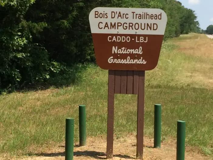
Overview This location is available on a first-come, first-served basis only. Visitors are required to physically arrive at the campground to purchase and claim a site. Once on-site, you may be able to pay for your campsite(s) by scanning a QR code using the Recreation.gov mobile app, and the Scan and Pay feature. If this option is available, you will need to first download the free Recreation.gov mobile app https://www.recreation.gov/mobile-app prior to your arrival as some remote areas have limited or no cellular service. Bois D'Arc Trailhead has 28 campsites with picnic tables. Bois D'Arc Trailhead also has a pailion with grill. Nearby Attractions Lake Davy Crockett and Coffee Mill Lake
View details →
Overview This location is available on a first-come, first-served basis only. Visitors are required to physically arrive at the campground to purchase and claim a site. Once on-site, you may be able to pay for your campsite(s) by scanning a QR code using the Recreation.gov mobile app, and the Scan and Pay feature. If this option is available, you will need to first download the free Recreation.gov mobile app https://www.recreation.gov/mobile-app prior to your arrival as some remote areas have limited or no cellular service. Coffee Mill Campgrouns has 13 campsites and is open year-round. There is boat access to the 750 acre Coffee Mill Lake and a new fishing pier. Nearby Attractions Lake Davy Crockett and non-motorized trails.
View details →
Overview This location is available on a first-come, first-served basis only. Visitors are required to physically arrive at the campground to purchase and claim a site. Once on-site, you may be able to pay for your campsite(s) by scanning a QR code using the Recreation.gov mobile app, and the Scan and Pay feature. If this option is available, you will need to first download the free Recreation.gov mobile app https://www.recreation.gov/mobile-app prior to your arrival as some remote areas have limited or no cellular service. Valley View Campground has 15 campsites and a 20' x 40' pavilion with grill. There is water for horses. Nearby Attractions Non-motorized trails and small ponds
View details →
Overview This location is available on a first-come, first-served basis only. Visitors are required to physically arrive at the campground to purchase and claim a site. Once on-site, you may be able to pay for your campsite(s) by scanning a QR code using the Recreation.gov mobile app, and the Scan and Pay feature. If this option is available, you will need to first download the free Recreation.gov mobile app https://www.recreation.gov/mobile-app prior to your arrival as some remote areas have limited or no cellular service. West Lake Crockett Campground has 12 campsites. Located on 450 acre Lake Davy Crockett. Nearby Attractions Coffee Mill Lake and Bois D'Arc Trailhead.
View details →
Overview Situated on the United States-Mexico border, Amistad National Recreation Area is known primarily for excellent year-round, Outdoor Activities including boating, fishing, swimming, scuba diving, and waterskiing. Amistad National Recreation Area also provides opportunities for picnicking, camping, and hunting. Amistad Dam created the reservoir at the confluence of the Rio Grande, Devils, and Pecos Rivers in 1969. In addition to excellent recreation, Amistad National Recreation Area is rich in archeology and rock art and contains a wide variety of plant and animal life. Amistad park headquarters is in Del Rio, Texas, population 35,000 Recreation Amistad National Recreation Area offers a diverse array of land- and water-based recreational opportunities, including fishing, swimming, boating, birding, hiking, picnicking, camping, and hunting. Visitors can experience expansive views, night skies, and a number of the area’s rock art sites. Examples of facilities that support these activities include boat ramps, picnic and camping areas, and hiking trails. Facilities Amistad National Recreation Area offers a diverse array of land- and water-based recreational opportunities, including fishing, swimming, boating, birding, hiking, picnicking, camping, and hunting. Visitors can experience expansive views, night skies, and a number of the area’s rock art sites. Examples of facilities that support these activities include boat ramps, picnic and camping areas, and hiking trails. Natural Features Amistad National Recreation Area consists of 57,292 acres (23185 ha) of federally owned land and is one of the largest tracts of land available for hunting in southwest Texas. Three ecological zones and three rivers meet at Amistad National Recreation Area. Plant communities are determined by topography, soil type, and rainfall and support a wide variety of plant and animal life. Rugged canyons provide outstanding scenic vistas. A majority of Amistad National Recreation Area contains Lake Amistad, which is fed by the Pecos, Rio Grande, and Devils Rivers. Crystal clear stretches of river, natural springs, and fluctuating reservoir levels support a variety of aquatic plant and animal species. The recreation area has some of the best bass fishing in the American Southwest. Nearby Attractions Lake Amistad is a top quality fishing spot for largemouth, smallmouth and striped bass. Amistad National Recreation Area offers 12 boat ramps allowing access to Lake Amistad, however, due to low water levels only 4 ramps remain open. Boat rentals are available at Rough Canyon just 29 miles (47 km) from Rock Quarry Group Campground. Park Approved Guides and Rentals offer activities such as guided fishing and kayak trips on the lake. Texas Parks and Wildlife maintains 3 state parks in the area; Kickapoo Cavern State Park (67 miles/108 km NE off of Ranch Road 674 ) offering guided cave tours, Devils River State Natural Area (67 Miles/108 km NW off of St Hwy 277) offering paddling, swimming and fishing opportunities and Seminole Canyon State Park & Historical Site (26 miles/42 km NW off of Hwy 90) offering world class ancient rock art viewing. The campground is just 15 miles (24 km) NW of Del Rio, TX (pop. around 35,0000). Del Rio enjoys many restauraunts, a movie theater and shopping. Charges & Cancellations Canellations and/or changes must be made at least two days in advance in order to receive a refund. All camping regulations apply.
View details →
Overview Situated on the United States-Mexico border, Amistad National Recreation Area is known primarily for excellent year-round, water-based recreation including boating, fishing, swimming, scuba diving, and waterskiing. Amistad National Recreation Area also provides opportunities for picnicking, camping, and hunting. Amistad Dam created the reservoir at the confluence of the Rio Grande, Devils, and Pecos Rivers in 1969. In addition to excellent recreation, Amistad National Recreation Area is rich in archeology and rock art and contains a wide variety of plant and animal life. Amistad park headquarters is in Del Rio, Texas, population 35,000. Recreation Amistad National Recreation Area offers a diverse array of land- and water-based Outdoor Activities including fishing, swimming, boating, birding, hiking, picnicking, camping, and hunting. Visitors can experience expansive views, night skies, and a number of the area’s rock art sites. Examples of facilities that support these activities include boat ramps, picnic and camping areas, and hiking trails. Facilities Amistad National Recreation Area offers a diverse array of land- and water-based Outdoor Activities including fishing, swimming, boating, birding, hiking, picnicking, camping, and hunting. Visitors can experience expansive views, night skies, and a number of the area’s rock art sites. Examples of facilities that support these activities include boat ramps, picnic and camping areas, and hiking trails. Natural Features Amistad National Recreation Area consists of 57,292 acres (23185 ha) of federally owned land and is one of the largest tracts of land available for hunting in southwest Texas. Three ecological zones and three rivers meet at Amistad National Recreation Area. Plant communities are determined by topography, soil type, and rainfall and support a wide variety of plant and animal life. Rugged canyons provide outstanding scenic vistas. A majority of Amistad National Recreation Area contains Lake Amistad, which is fed by the Pecos, Rio Grande, and Devils Rivers. Crystal clear stretches of river, natural springs, and fluctuating reservoir levels support a variety of aquatic plant and animal species. The recreation area has some of the best bass fishing in the American Southwest. Nearby Attractions Lake Amistad is a top quality fishing spot for largemouth, smallmouth and striped bass. Amistad National Recreation Area offers 12 boat ramps allowing access to Lake Amistad, however, due to low water levels only 4 ramps remain open. Boat rentals are available at Rough Canyon just 15 miles (24 km) from 277 North Campground. Park Approved Guides and Rentals offer activities such as guided fishing and kayak trips on the lake. Texas Parks and Wildlife maintains 3 state parks in the area-- Kickapoo Cavern State Park (63 miles/101 km NE off of Ranch Road 674), offering guided cave tours, Devils River State Natural Area (50 Miles/80 km NW off of St Hwy 277) offering paddling, swimming and fishing opportunities and Seminole Canyon State Park and Historic Site (41 miles/66 km NW off of Hwy 90), offering world class ancient rock art viewing. 277 North Group Campground is 11 miles (18 km) north of Del Rio, TX (pop. 35,0000). Del Rio enjoys many restauraunts, a movie theater and shopping.
View details →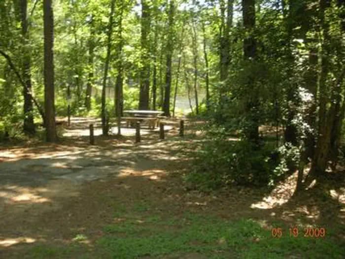
Overview Double Lake Recreation Area was built in 1937 by the Civilian Conservation Corps and offers a little of everything, including camping, fishing, swimming, picnicking, hiking and simply relaxing in nature. A variety of tent, RV and group campsites are available. Recreation Double Lake is open for fishing year round. Only boats with small electric motors are allowed. A 5-mile hiking trail leads to Big Creek Scenic Area, and there is access to part of the 128-mile Lone Star Hiking Trail. A 20-mile mountain bike trail meanders around the lake. Swimmers can relax on a sandy beach after taking a cool plunge. Learn more about recreation in the national forest. Facilities Double Lake is open for fishing year round. Only boats with small electric motors are allowed. A 5-mile hiking trail leads to Big Creek Scenic Area, and there is access to part of the 128-mile Lone Star Hiking Trail. A 20-mile mountain bike trail meanders around the lake. Swimmers can relax on a sandy beach after taking a cool plunge. Learn more about recreation in the national forest. Natural Features The area has rolling hills forested with hardwood and pines. The campground is surrounded by the 23-acre Double Lake. Temperatures are moderate to cool from September through May, and hot and humid from June to August. Winters are cool and wet. contact_info For facility specific information, please call (936) 344-6205.
View details →
Overview The year-round campground at Airport Park is perfectly located between Waco Lake and the Waco Airport. Campers can look south and view the pristine waters of the lake, or look north and watch airplanes take off and land. Recreation The main lake shoreline has a large amount of submerged timber, which typically holds fish year-round. Anglers will find plenty of catfish, crappie, large and smallmouth bass as well as sunfish. A boat ramp and dock help visitors enjoy the lake. Facilities The main lake shoreline has a large amount of submerged timber, which typically holds fish year-round. Anglers will find plenty of catfish, crappie, large and smallmouth bass as well as sunfish. A boat ramp and dock help visitors enjoy the lake. Natural Features Airport Park is on the northern banks of Waco Lake, near the dam. The lake is primarily fed by the Bosque River, which runs for 115 miles through central Texas. contact_info For local information, please call (254) 756-5359 or call (877) 444-6777 for general information. Nearby Attractions Airport Park is located within the City of Waco and is 10 miles from Magnolia Market. About 15 min from Airport Park, Waco Lake Wetlands offers educational tours that take visitors through a six-acre nursery of aquatic plants and more than 130 species of birds. Cameron Park Zoo is also located nearby.
View details →
Overview Alley Creek Campground is situated along the banks of Lake O' the Pines in the Ark-La-Tex portion of the Pineywoods of east Texas near the states of Arkansas, Oklahoma, and Louisiana. Gate House Hours: 10am-6pm Monday through Saturday, 12pm-6pm Sunday Recreation Boating, fishing, water sports, and wildlife viewing are all popular pastimes at the campground. Hunting opportunities for white-tailed deer, waterfowl, and small game are available on nearby public lands. Lake O' the Pines fishing includes largemouth, spotted, and white bass along with crappie, catfish, and sunfish. In addition to boat fishing there are areas for bank fishing along the shore and below the dam along Big Cypress Bayou. Birdwatchers are also encouraged to bring their binoculars as numerous resident and migratory bird species inhabit the area. Bald eagle sightings are a common occurrence in fall and winter and they are occasionally sighted in spring and summer. Facilities Boating, fishing, water sports, and wildlife viewing are all popular pastimes at the campground. Hunting opportunities for white-tailed deer, waterfowl, and small game are available on nearby public lands. Lake O' the Pines fishing includes largemouth, spotted, and white bass along with crappie, catfish, and sunfish. In addition to boat fishing there are areas for bank fishing along the shore and below the dam along Big Cypress Bayou. Birdwatchers are also encouraged to bring their binoculars as numerous resident and migratory bird species inhabit the area. Bald eagle sightings are a common occurrence in fall and winter and they are occasionally sighted in spring and summer. Natural Features Lake O' the Pines includes about 18,700 acres of water and 9,000 acres of land, encompassing an area so large it spans five counties. The lake was created by the construction of the Ferrell's Bridge Dam on the Big Cypress Bayou. The reservoir was originally created as part of an overall plan for flood control in the Red River Basin below Denison Dam in Oklahoma, and has now become a recreational oasis for outdoor enthusiasts. Nearby Attractions The nearby towns of Jefferson and Marshall offer historic and tourist attractions, and Texas Wildflower Trail routes are located along the roads surrounding the lake.
View details →
Overview Brushy Creek Campground is situated along the banks of Lake O' the Pines in the Ark-La-Tex portion of the Pineywoods of east Texas near the states of Arkansas, Oklahoma, and Louisiana. Gate House Hours: 10am-6pm Monday through Saturday, 12pm-6pm Sunday. Address to get here: 189 Brushy Creek Park Rd. Jefferson, TX 75657 Recreation Boating, fishing, water sports, and wildlife viewing are all popular pastimes at the campground. Hunting opportunities for white-tailed deer, waterfowl, and small game are available on nearby public lands. Lake O' the Pines fishing includes largemouth, spotted, and white bass along with crappie, catfish, and sunfish. In addition to boat fishing there are areas for bank fishing along the shore and below the dam along Big Cypress Bayou. Birdwatchers are also encouraged to bring their binoculars as numerous resident and migratory bird species inhabit the area. Bald eagle sightings are a common occurrence in fall and winter and they are occasionally sighted in spring and summer. Facilities Boating, fishing, water sports, and wildlife viewing are all popular pastimes at the campground. Hunting opportunities for white-tailed deer, waterfowl, and small game are available on nearby public lands. Lake O' the Pines fishing includes largemouth, spotted, and white bass along with crappie, catfish, and sunfish. In addition to boat fishing there are areas for bank fishing along the shore and below the dam along Big Cypress Bayou. Birdwatchers are also encouraged to bring their binoculars as numerous resident and migratory bird species inhabit the area. Bald eagle sightings are a common occurrence in fall and winter and they are occasionally sighted in spring and summer. Natural Features Lake O' the Pines includes about 18,700 acres of water and 9,000 acres of land, encompassing an area so large it spans five counties. The lake was created by the construction of the Ferrell's Bridge Dam on the Big Cypress Bayou. The reservoir was originally created as part of the overall plan for flood control in the Red River Basin below Denison Dam in Oklahoma, and has now become a recreational oasis for outdoor enthusiasts. Nearby Attractions The nearby towns of Jefferson and Marshall offer plenty of historic and tourist attractions, and Texas Wildflower Trail routes are located along the roads surrounding the lake.
View details →
Overview Buckhorn Creek Campground is situated along the banks of Lake O' the Pines in the Ark-La-Tex portion of the Pineywoods of east Texas near the states of Arkansas, Oklahoma, and Louisiana. Gate House Hours: 10am-6pm Monday through Saturday, 12pm-6pm Sunday. Address to get here: 2669 FM 726, Jefferson, TX 75657 Recreation Boating, fishing, water sports, and wildlife viewing are all popular pastimes at the campground. Hunting opportunities for white-tailed deer, waterfowl, and small game are available on nearby public lands. Lake O' the Pines fishing includes largemouth, spotted, and white bass along with crappie, catfish, and sunfish. In addition to boat fishing there are areas for bank fishing along the shore and below the dam along Big Cypress Bayou. Birdwatchers are also encouraged to bring their binoculars as numerous resident and migratory bird species inhabit the area. Bald eagle sightings are a common occurrence in fall and winter and they are occasionally sighted in spring and summer. Facilities Boating, fishing, water sports, and wildlife viewing are all popular pastimes at the campground. Hunting opportunities for white-tailed deer, waterfowl, and small game are available on nearby public lands. Lake O' the Pines fishing includes largemouth, spotted, and white bass along with crappie, catfish, and sunfish. In addition to boat fishing there are areas for bank fishing along the shore and below the dam along Big Cypress Bayou. Birdwatchers are also encouraged to bring their binoculars as numerous resident and migratory bird species inhabit the area. Bald eagle sightings are a common occurrence in fall and winter and they are occasionally sighted in spring and summer. Natural Features Lake O' the Pines includes about 18,700 acres of water and 9,000 acres of land, encompassing an area so large it spans five counties. The lake was created by the construction of the Ferrell's Bridge Dam on the Big Cypress Bayou. The reservoir was originally created as part of the overall plan for flood control in the Red River Basin below Denison Dam in Oklahoma, and has now become a recreational oasis for outdoor enthusiasts. Nearby Attractions The nearby towns of Jefferson and Marshall offer plenty of historic and tourist attractions, and Texas Wildflower Trail routes are located along the roads surrounding the lake.
View details →
Overview Cedar Ridge Park Campground is located at Belton Lake, which provides some of the best fishing, camping and boating in Central Texas. This year-round campground accommodates both tents and RVs and has several sites with screened shelters for those who do not have camping equipment. The facility provides many amenities, including hot showers and group picnic areas . A concession marina within the park offers fuel and basic convenience store items, as well as a seasonal restaurant. Belton Lake was created by the U.S. Army Corps of Engineers with the construction of Belton Dam in 1954. The 12,300-acre lake is located on the Leon River, just upstream of the confluence of the Leon River and the Little River. Recreation With 136 miles of shoreline, Belton Lake offers a wide variety of recreation activities, and there is no shortage of family activities at Cedar Ridge. The facility has two multi-lane boat ramps with courtesy loading docks, a large lighted fishing dock, a designated family swimming beach, a playground, basketball court and hiking trails. Hawks, Great blue herons, ducks, geese, many species of songbirds, bobwhite quail, Rio Grande turkey and even an occasional bald eagle visit the lake area, yielding year-round opportunities for birders. Facilities With 136 miles of shoreline, Belton Lake offers a wide variety of recreation activities, and there is no shortage of family activities at Cedar Ridge. The facility has two multi-lane boat ramps with courtesy loading docks, a large lighted fishing dock, a designated family swimming beach, a playground, basketball court and hiking trails. Hawks, Great blue herons, ducks, geese, many species of songbirds, bobwhite quail, Rio Grande turkey and even an occasional bald eagle visit the lake area, yielding year-round opportunities for birders. Natural Features The campground is partially forested with a mix of sun and shade. It lies on the shores of Belton Lake and Cedar Creek, with its scenic white limestone bluffs. Some of the campsites are directly on the shore, while others are a short walk away. The springtime brings an abundance of wildflowers that blanket areas of the park. Deer, turkey and other small game are commonly seen, and a man-made wetland on the opposite side of the lake provides an additional 25 acres of wildlife habitat in the area. Nearby Attractions Belton Lake is located adjacent to the Fort Hood Army Base, which has several points of interest for the military buff. The mural painted on the spillway wall of Belton Dam depicts the history of the Bell County area. contact_info For facility specific information, please call (254) 742-3050.
View details →
Overview Cedron Creek Campground is located on Whitney Lake on the main channel of the Brazos River in Central Texas. The majority of campsites in Cedron Creek are 30 amp electric hook ups with water and 10 sites have water and 50 amp electric hook ups. Each site has a stand up BBQ cooker or a ground cooker/fire ring. The park also has 3 restrooms, showers, horseshoe pits, a trailer dump station, boat ramp and a playground. Recreation Boating, fishing, swimming, canoeing and kayaking are popular activities at Whitney Lake. Anglers can fish for a variety of bass, crappie and catfish. Facilities Boating, fishing, swimming, canoeing and kayaking are popular activities at Whitney Lake. Anglers can fish for a variety of bass, crappie and catfish. Natural Features Cedron Creek is situated on the lakeshore among rolling hills covered with cedar, live and post oak. Nearby Attractions The 12.5 mile Hopewell Trail is nearby. It allows hiking, mountain biking, and horseback riding. Visitors can choose to travel north on the trail to Kimball Bend Park, or south to Lakeside Village and Powelldale Mountain.
View details →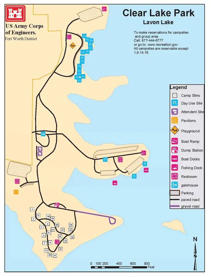
Overview Clear Lake Campground has a prime location on the shores of Lavon Lake. It is the only shaded campground at the lake, and provides a quiet space for anglers, bird watchers and photographers. The park is just northeast of Dallas, Texas, and just east of the Southfork Ranch, where the hit TV series, "Dallas," was filmed. Recreation Visitors of all ages enjoy outdoor opportunities like fishing, boating, hiking, and picnicking. Anglers often find channel catfish, crappie, striped bass and hybrid bass. Facilities Visitors of all ages enjoy outdoor opportunities like fishing, boating, hiking, and picnicking. Anglers often find channel catfish, crappie, striped bass and hybrid bass. Natural Features Grassy flat fields and leafy shade trees cover the campground. The Lavon Lake spans 21,400 acres and stems from the East Fork of the Trinity River. Nearby Attractions The town of Wylie is home to a wildlife rescue and education center. Visitors can see lions, leopards, cougars, bobcats and more.
View details →
Overview Clear Spring Park sits along the shore of 30,000-acre Wright Patman Lake within the piney woods of northeast Texas. The campground offers full services to campers. With a boat ramp, playground and swimming area, Clear Spring is sure to provide outdoor fun for families, boaters, anglers and hunters alike. Recreation Wright Patman Lake hosts a wide range of recreational activities, including camping, swimming, boating, fishing, hunting, hiking, picnicking and wildlife viewing. Boaters flock to the lake and anglers try their luck for largemouth bass, catfish, crappie, sunfish and bass. The campground also offers hiking and nature trails. Facilities Wright Patman Lake hosts a wide range of recreational activities, including camping, swimming, boating, fishing, hunting, hiking, picnicking and wildlife viewing. Boaters flock to the lake and anglers try their luck for largemouth bass, catfish, crappie, sunfish and bass. The campground also offers hiking and nature trails. Natural Features The campground is located in a southern pine forest overlooking the lake. Many campsites are on the water's edge. The U.S. Army Corps of Engineers manages approximately 55,000 acres of public forestland around the lake, providing habitat for wild turkey, bobwhite quail, squirrel, white-tailed deer, waterfowl and migrating bald eagles, pelicans and ducks. Some poisonous snakes inhabit the area. Nearby Attractions The Texarkana region is full of activities such as shopping, movies, restaurants and local historical sites. Shreveport, Louisiana offers river boat gambling, horse races and numerous festivals, including the Four State Fair and Rodeo and the Jump, Jive and Jam Festival.
View details →
Overview Copperas Creek Park is nestled within the beautiful Cross Timbers Region of Texas and located on the southwestern side of Proctor Lake. Copperas Creek appeals to sportsmen, birdwatchers, naturalists or those simply wanting to relax in the outdoors. Recreation Copperas Creek offers families and friends with an excellent venue to enjoy the outdoors. The park offers overnight camping as well as a day-use area for picnicing and several swim beaches for folks to soak up the sun and enjoy the beautiful lake water. Fishing is Proctor Lake's main attraction: anglers enjoy the lake's tremendous populations of Bass, Crappie, and Catfish. The lake is also recognized as one of the best Hybrid Striped Bass fishing areas in the state. Copperas Creek offers three boat ramps that provides guests with easy access to the lake. Also, two fishing docks are located within the park and one fishing platform located in deep water and immediately in front of the Proctor Lake dam. High Point Park, located adjacent to Sowell Creek Park on FM 1496 (31.999944, -98.470486), offers more than 10 miles of of hiking and equestrian trails. Facilities Copperas Creek offers families and friends with an excellent venue to enjoy the outdoors. The park offers overnight camping as well as a day-use area for picnicing and several swim beaches for folks to soak up the sun and enjoy the beautiful lake water. Fishing is Proctor Lake's main attraction: anglers enjoy the lake's tremendous populations of Bass, Crappie, and Catfish. The lake is also recognized as one of the best Hybrid Striped Bass fishing areas in the state. Copperas Creek offers three boat ramps that provides guests with easy access to the lake. Also, two fishing docks are located within the park and one fishing platform located in deep water and immediately in front of the Proctor Lake dam. High Point Park, located adjacent to Sowell Creek Park on FM 1496 (31.999944, -98.470486), offers more than 10 miles of of hiking and equestrian trails. Natural Features Large, open grassy areas; Cottonwoods; Black Willow; and Cypress trees characterize the campground: Some campsites have shade and the lake views are plentiful. Nearby Attractions The surrounding towns of Comanche, De Leon, and Dublin offers historical attractions, antique stores. museums, events and more.
View details →
Overview Dana Peak Campground is located on a peninsula on the shoreline of Stillhouse Hollow Lake in central Texas. The lake offers a wide variety of recreation opportunities, including water sports, hiking, biking, horseback riding, picnicking, large group pavilions, hunting, fishing and more. The facility is one of only two reservable campgrounds on the lake and often fills up on weekends during summer. Stillhouse Hollow Lake was created by the U.S. Army Corps of Engineers with the construction of Stillhouse Hollow Dam in 1968. The 6,430-acre lake is located 16 miles upstream of the confluence of the Lampasas and Leon Rivers, which flow into the Little River. Recreation With 58 miles of shoreline, Stillhouse Hollow Lake is an often uncrowded haven for boaters and fishermen. The campground has a four-lane boat ramp, and visitors who do not have motor boats, canoes or kayaks can rent them nearby. Families can enjoy soaking up the sun, swimming at the beach or exploring the Dana Peak Trails (located just outside the main entrance to the park) by foot, bike or horseback. Birding is a favorite pastime for many visitors with hawks, Great Blue herons, ducks, geese, many species of songbirds, bobwhite quail, Rio Grande turkey and even an occasional bald eagle, yielding year-round opportunities for bird sightings. Facilities With 58 miles of shoreline, Stillhouse Hollow Lake is an often uncrowded haven for boaters and fishermen. The campground has a four-lane boat ramp, and visitors who do not have motor boats, canoes or kayaks can rent them nearby. Families can enjoy soaking up the sun, swimming at the beach or exploring the Dana Peak Trails (located just outside the main entrance to the park) by foot, bike or horseback. Birding is a favorite pastime for many visitors with hawks, Great Blue herons, ducks, geese, many species of songbirds, bobwhite quail, Rio Grande turkey and even an occasional bald eagle, yielding year-round opportunities for bird sightings. Natural Features Aside from two campgrounds and a nearby day-use park, very little of the lakeshore is developed. The edges consist of rocky beaches and sandy bluffs. Much of the lake area is forested, though the campground is mostly grassy, flat and open with little to no shade. Most campsites are right along the water's edge; others are within a short walk. The lake has noticeably clear and deep water inhabited by largemouth bass, smallmouth bass and channel catfish. A man-made wetland was constructed on the south shore of the lake, providing an additional 10 acres of wildlife habitat in the area. contact_info This location is unstaffed. To speak with our main office for general information, please call: (254) 939-2461. Nearby Attractions Within a short drive, the Village of Salado offers golf, art galleries and shopping, among other pastimes. Chalk Ridge Falls Environmental Learning Center is below the Stillhouse Hollow Lake Dam. The center has about five miles of hiking trails, including a one-mile nature trail along the Lampasas River, a spring-fed creek, a waterfall, bridges and several wildlife viewing points. Stillhouse Hollow Lake is located near the Fort Hood Army Base, which has several points of interest for the military buff.
View details →
Overview East Fork Campground, on the southern shores of Lavon Lake, is a popular escape for city dwellers in the Dallas, Texas area or for any visitors passing through the Northern Texas region. The campground boasts everything including RV campsites, tent campsites, equestrian campsites, a group shelter and a swimming beach to keep visitors entertained during their stay. Recreation Boating and fishing are consistently popular activities for lake-goers. Horseback riding and hiking is great along the Trinity Trail, with a trailhead beginning adjacent to the East Fork campground. Facilities Boating and fishing are consistently popular activities for lake-goers. Horseback riding and hiking is great along the Trinity Trail, with a trailhead beginning adjacent to the East Fork campground. Natural Features Lavon Lake, in northern Texas, flows from the East Fork tributary of the Trinity River. Its surface area spans 21,400 acres and the maximum lake depth of around 59 ft.. Nearby Attractions The Heard Natural Science Museum and Wildlife Sanctuary features natural history exhibits and nature trails.
View details →
Overview Flatrock campground is situated on Hords Creek Lake with nice shade from trees, a fishing dock and gravel swimming areas for beating the Texas heat. Recreation Visitors come to Flatrock for fishing, boating and simple relaxation. The popular catches on the lake include largemouth bass, sunfish and white crappie. When water levels are high enough, water skiing is also a fun sport here. Facilities Visitors come to Flatrock for fishing, boating and simple relaxation. The popular catches on the lake include largemouth bass, sunfish and white crappie. When water levels are high enough, water skiing is also a fun sport here. Natural Features Hords Creek Lake is in the center of Texas, north of the Texas Hill Country. Gently rolling hills covered with live oaks make Hords Creek Lake a beautiful getaway, despite the sometimes unbearable heat. Nearby Attractions Circle the lake to cruise through neighboring Friendship Park and Lakeside Park. For a dose of city conveniences, head to Coleman, just eight miles east of the lake. Charges & Cancellations Standard Cancellation Rates Apply.
View details →
Overview Holiday Park campground is on the west side of Benbrook Lake in north central Texas and accessible from US Hwy 377. Camping, hiking & horseback trails, boat launch, fishing & wildlife viewing are available. Recreation Holiday Park campground is the main park for individual and family camping year-round. Developed trails run throughout Holiday Park, offering hiking & horseback riding. Visitors can spot deer, turkey, bluebirds, kinglets, woodpeckers and chickadees. Facilities Holiday Park campground is the main park for individual and family camping year-round. Developed trails run throughout Holiday Park, offering hiking & horseback riding. Visitors can spot deer, turkey, bluebirds, kinglets, woodpeckers and chickadees. Natural Features Holiday Park campground varies from wooded bottoms to upland prairie, with open shorelines and rocky hillsides. Nearby Attractions Fort Worth’s renowned Cultural & Museum District, Stockyards National Historic District, Botanical Gardens, Zoo, Bass Performance Hall, and Sundance Square downtown, are all nearby. contact_info For local information, please call (817) 292-2400 or call (877) 444-6777 for general information.
View details →
Overview Johnson Creek Campground is situated along the banks of Lake O' the Pines in the in the Ark-La-Tex portion of the Pineywoods of east Texas near Arkansas, Oklahoma, and Louisiana. Gate House Hours: 10am-6pm Monday through Saturday, 12pm-6pm Sunday. Address to get here: 580 Crestwood Lp. Avinger, TX 75657 Recreation Boating, fishing, water sports, and wildlife viewing are all popular pastimes at the campground. Hunting opportunities for white-tailed deer, waterfowl, and small game are available on nearby public lands. Lake O' the Pines fishing includes largemouth, spotted, and white bass along with crappie, catfish, and sunfish. In addition to boat fishing there are areas for bank fishing along the shore and below the dam along Big Cypress Bayou. Birdwatchers are also encouraged to bring their binoculars as numerous resident and migratory bird species inhabit the area. Bald eagle sightings are a common occurrence in fall and winter and they are occasionally sighted in spring and summer. Facilities Boating, fishing, water sports, and wildlife viewing are all popular pastimes at the campground. Hunting opportunities for white-tailed deer, waterfowl, and small game are available on nearby public lands. Lake O' the Pines fishing includes largemouth, spotted, and white bass along with crappie, catfish, and sunfish. In addition to boat fishing there are areas for bank fishing along the shore and below the dam along Big Cypress Bayou. Birdwatchers are also encouraged to bring their binoculars as numerous resident and migratory bird species inhabit the area. Bald eagle sightings are a common occurrence in fall and winter and they are occasionally sighted in spring and summer. Natural Features Lake O' the Pines includes about 18,700 acres of water and 9,000 acres of land, encompassing an area so large it spans five counties. The lake was created by the construction of the Ferrell's Bridge Dam on the Big Cypress Bayou. The reservoir was originally created as part of the overall plan for flood control in the Red River Basin below Denison Dam in Oklahoma, and has now become a recreational oasis for outdoor enthusiasts. Nearby Attractions Other historic and tourist attractions are nearby in the towns of Jefferson and Marshall, and Texas Wildflower Trail routes are located along the roads surrounding the lake.
View details →
Overview The Lakeside Campground and Recreation Area is partially open year-round on the northern side Hords Creek Lake and fully open March 1 through September 30 . Recreation Bring your rod for fishing that includes largemouth bass, white crappie, channel and flathead catfish and sunfish. The record largemouth bass caught here is 11 pounds 4 ounces. Facilities Bring your rod for fishing that includes largemouth bass, white crappie, channel and flathead catfish and sunfish. The record largemouth bass caught here is 11 pounds 4 ounces. Natural Features The lake is nestled in the middle of Texas, surrounded by gently rolling hills dotted with Live oak trees. Nearby Attractions Drive through neighboring Friendship Park and Lakeside Park or for a dose of city conveniences, head to Coleman, just eight miles east of the lake. Charges & Cancellations Standard Cancellation Rates Apply.
View details →
Overview Lavonia Campground is a scenic Texas getaway just beyond the Dallas metropolitan area. Visitors can camp, swim, fish, boat or use the day use area. Recreation Visitors of all ages can enjoy activities like camping, fishing, boating and picnicking. Anglers seek species like channel catfish, crappie and striped bass. Facilities Visitors of all ages can enjoy activities like camping, fishing, boating and picnicking. Anglers seek species like channel catfish, crappie and striped bass. Natural Features The Lavon Lake, in northern Texas, spans 21,400 acres and stems from the East Fork of the Trinity River. Nearby Attractions The paved Sister Groves Trail at Sister Grove Creek is a hot spot for biking and hiking. contact_info For facility specific information, please call (877) 444-6777.
View details →
Overview Live Oak Ridge Campground is located at Belton Lake, which provides some of the best fishing, camping and boating in Central Texas. This year-round campground accommodates both tents and RVs and has many amenities, such as a playground, showers, and a group meeting area. Belton Lake was created by the U.S. Army Corps of Engineers with the construction of Belton Dam in 1954. The 12,300-acre lake is located on the Leon River, just upstream of the confluence of the Leon River and the Little River. Recreation With 136 miles of shoreline, Belton Lake offers a wide variety of recreation activities, including camping, water recreation, picnicking and nature trails. The facility has a multi-lane boat ramp, and hiking trails are available adjacent to the park at Miller Springs Nature Area. Hawks, great blue herons, ducks, geese, many species of songbirds, bobwhite quail, Rio Grande turkey and even an occasional bald eagle visit the lake area, offering year-round opportunities for birders. Facilities With 136 miles of shoreline, Belton Lake offers a wide variety of recreation activities, including camping, water recreation, picnicking and nature trails. The facility has a multi-lane boat ramp, and hiking trails are available adjacent to the park at Miller Springs Nature Area. Hawks, great blue herons, ducks, geese, many species of songbirds, bobwhite quail, Rio Grande turkey and even an occasional bald eagle visit the lake area, offering year-round opportunities for birders. Natural Features Live Oak Ridge lives up to its name, with many large oak trees, a pleasant atmosphere and plenty of shade. The campsites are flat and grassy, and several overlook the lake (others are only a short walk away). Springtime brings an abundance of wildflowers that blanket areas of the park. There is a man-made wetland on the lake between White Flint and Winkler Parks, providing an additional 25 acres of wildlife habitat to the lake area. contact_info For facility specific information, please call (254) 742-3050. Nearby Attractions Belton Lake is located adjacent to the Fort Hood Army Base, which has several points of interest for the military buff. The mural painted on the spillway wall of Belton Dam depicts the history of the Bell County area.
View details →
Overview Lofers Bend East Campground is located on Whitney Lake on the Brazos River in Central Texas. This campground has 66 campsites and six of which that are "water only" sites and the remaining sites have water and 30 amp hook ups. All sites have either a stand up BBQ grill or a ground cooker/fire ring. The park is equipped with flushable toilets, showers, trailer dump station and two boat ramps. Recreation Boating, fishing, swimming, canoeing, and kayaking are popular activities at Whitney Lake. Anglers can fish for a variety of bass, crappie and catfish. Facilities Boating, fishing, swimming, canoeing, and kayaking are popular activities at Whitney Lake. Anglers can fish for a variety of bass, crappie and catfish. Natural Features The park is situated on the lakeshore among rolling hills covered with cedar, live, and post oak trees. Many deer claim this campground as their home. Nearby Attractions
View details →
Overview Mill Creek Park is a large, comfortable campground on the Sam Rayburn Reservoir, also known as Lake Sam Rayburn, tucked in the piney woods of southeast Texas. The lake and the surrounding Angelina National Forest, provide a welcoming home for bald eagles in winter. The rare red-cockaded woodpecker also resides in the forest here. Recreation Fishing at the reservoir is wildly popular, with frequent fishing tournaments. Catches include largemouth bass, crappie and catfish. Birding is also big, with chances to see warblers, vireos and other migratory songbirds. A resident population of wood ducks remains in the forest throughout the year. Facilities Fishing at the reservoir is wildly popular, with frequent fishing tournaments. Catches include largemouth bass, crappie and catfish. Birding is also big, with chances to see warblers, vireos and other migratory songbirds. A resident population of wood ducks remains in the forest throughout the year. Natural Features The campground is on the southeast shores of Sam Rayburn Reservoir. The lake boasts over 114,000 surface acres, making it the largest man-made lake that's completely located in Texas. Nearby Attractions From the eastern edge of the lake, hikers can embark on a 28-mile trail that heads east to the Toledo Bend Reservoir.
View details →
Overview Mustang Park is a spacious dayuse area on the south side of Benbrook Lake in north-central Texas, accessible from WInscott Plover Road. Swimming, picnicking, fishing, boat launching, and wildlife viewing are available. Recreation Mustang is a unique recreation experience at Benbrook, where day-users are not restricted to designated table sites or roadways - you may set up and day-use anywhere in the park you like, even right on the shoreline. The adjacent swimming beach is popular, as is fishing along the shoreline of Mustang Point. Facilities Mustang is a unique recreation experience at Benbrook, where day-users are not restricted to designated table sites or roadways - you may set up and day-use anywhere in the park you like, even right on the shoreline. The adjacent swimming beach is popular, as is fishing along the shoreline of Mustang Point. Natural Features Mustang Park is on the west side of Mustang Creek on the south side of the Lake, with wooded creek bottoms and gently sloping shorelines. Nearby Attractions Fort Worth's renowned Cultural & Museum District, Stockyards National Historic District, Botanical Gardens, Zoo, Bass Performance Hall, and downtown Sundance Square, are all only a short drive. The campground closes at 10:00 p.m. so plan ahead.. contact_info This location has limited staffing. Please call (817) 292-2400 for general information.
View details →
Overview Piney Point Park is situated on the shore of 30,000-acre Wright Patman Lake within the piney woods of northeast Texas. This facility offers campers a complete range of services and year-round outdoor activities like fishing, hunting and wildlife viewing. Recreation Piney Point has plenty of open space and shade in which children can play, as well as a volleyball court and a 1.3-mile hiking trail that leads to nearby Rocky Point Campground and its swimming beach. Other activities on the lake include boating, fishing, hunting, picnicking and wildlife viewing. Boaters can make use of the park's boat ramp, and anglers can try their luck for bass, catfish, crappie and sunfish. Facilities Piney Point has plenty of open space and shade in which children can play, as well as a volleyball court and a 1.3-mile hiking trail that leads to nearby Rocky Point Campground and its swimming beach. Other activities on the lake include boating, fishing, hunting, picnicking and wildlife viewing. Boaters can make use of the park's boat ramp, and anglers can try their luck for bass, catfish, crappie and sunfish. Natural Features The park is located in a southern pine forest overlooking the lake. The U.S. Army Corps of Engineers manages approximately 55,000 acres of public forestland around the lake, providing habitat for wild turkey, bobwhite quail, squirrel, white-tailed deer, waterfowl and migrating bald eagles, pelicans and ducks. Some poisonous snakes inhabit the area. Nearby Attractions The Texarkana region is full of activities such as shopping, movies, restaurants and local historical sites. Shreveport, Louisiana offers river boat gambling, horse races and numerous festivals, including the Four State Fair and Rodeo and the Jump, Jive and Jam Festival.
View details →
Overview Plowman Creek Campground is located on the west side of Whitney Lake off the main channel of the Brazos River in Central Texas. Plowman Creek not only offers many campsites but also includes flush toilets, showers, drinking water, a dump station, boat ramp and playground. Recreation Boating, fishing, swimming, canoeing and kayaking are popular activities on the river and downstream at Whitney Lake. Anglers can fish for a variety of bass, crappie, and catfish. The 12.5 mile Hopewell Trail allows hiking, mountain biking and horseback riding. Visitors can choose to travel north on the trail to Kimball Bend Park, or south to Lakeside Village and Powelldale Mountain. Facilities Boating, fishing, swimming, canoeing and kayaking are popular activities on the river and downstream at Whitney Lake. Anglers can fish for a variety of bass, crappie, and catfish. The 12.5 mile Hopewell Trail allows hiking, mountain biking and horseback riding. Visitors can choose to travel north on the trail to Kimball Bend Park, or south to Lakeside Village and Powelldale Mountain. Natural Features The Brazos River flows gently over sand and rocks at Plowman Creek. The surrounding rolling hills are covered with cedar, Live oak and Post oak.
View details →
Overview Promontory Campground sits along Proctor Lake in the Cross Timbers Region of Texas. The area appeals to sportsmen, birders, naturalists or those simply wanting to relax in the outdoors. Recreation Fishing is Proctor Lake's main draw; anglers enjoy the lake's tremendous populations of bass, shad and crappie. The lake is also recognized as one of the best hybrid striped bass lakes in the state. Boating and swimming are popular activities on the water as well, and boat ramps and docks provide easy lake access for visitors. The surrounding wildlife areas at Proctor Lake provide ample hunting opportunities for game like duck, dove, hog and other small game animals. High Point Park, located just 2 miles from the campground, offers more than 10 miles of of hiking and equestrian trails. Facilities Fishing is Proctor Lake's main draw; anglers enjoy the lake's tremendous populations of bass, shad and crappie. The lake is also recognized as one of the best hybrid striped bass lakes in the state. Boating and swimming are popular activities on the water as well, and boat ramps and docks provide easy lake access for visitors. The surrounding wildlife areas at Proctor Lake provide ample hunting opportunities for game like duck, dove, hog and other small game animals. High Point Park, located just 2 miles from the campground, offers more than 10 miles of of hiking and equestrian trails. Natural Features Large grassy areas dotted with black willow trees and buttonbush characterize the campground. Shade is sparse, but lake views are plentiful. Nearby Attractions The nearby town of Comanche, Texas, offers historical attractions, antique stores. museums, events and more.
View details →
Overview Rocky Creek Park is located at Somerville Lake near Somerville, Texas. The lake offers various types of recreation such as camping, fishing, boating, swimming, nature trails and much more for registered campers only. Recreation Somerville Lake offers many opportunities for outdoor recreation. Water sports, hiking and biking are popular activities. The lake is great for crappie, catfish, white, hybrid-striped and largemouth bass fishing, with catches weighing up to 10 or more pounds. Facilities Somerville Lake offers many opportunities for outdoor recreation. Water sports, hiking and biking are popular activities. The lake is great for crappie, catfish, white, hybrid-striped and largemouth bass fishing, with catches weighing up to 10 or more pounds. Natural Features The campground is situated on a peninsula on scenic Somerville Lake. Some large trees cover the grounds, offering limited shade. Pelicans and other waterfowl frequent the shoreline. Nearby Attractions Yegua Creek Park is nearby, offering additional access to Somerville Lake and all its great water activities. The city of Somerville, Texas is less than 10 miles from Rocky Creek, offering restaurants and shops.
View details →
Overview Rocky Point Park offers a campground and group day use picnic shelter use on the shore of 30,000-acre Wright Patman Lake within the piney woods of northeast Texas. This large facility offers campers a complete range of services and year-round outdoor activities like fishing, hunting and wildlife viewing. Recreation Rocky Point has hiking and walking trails for registered campers, including a 1.3-mile trail that connects with nearby Piney Point Campground. Children enjoy the facility's swimming beach, playground, volleyball court and amphitheater with educational programs. Boaters and anglers can take advantage of the accessible boat ramp. Bass, catfish, crappie and sunfish are found in the lake. Facilities Rocky Point has hiking and walking trails for registered campers, including a 1.3-mile trail that connects with nearby Piney Point Campground. Children enjoy the facility's swimming beach, playground, volleyball court and amphitheater with educational programs. Boaters and anglers can take advantage of the accessible boat ramp. Bass, catfish, crappie and sunfish are found in the lake. Natural Features The park is situated in a mixed hardwood-pine forest next to Wright Patman Lake. The U.S. Army Corps of Engineers manages approximately 55,000 acres of public forestland around the lake, providing habitat for wild turkey, bobwhite quail, squirrel, white-tailed deer, waterfowl and migrating bald eagles, pelicans and ducks. Some poisonous snakes inhabit the area. Nearby Attractions The Texarkana region is full of activities such as shopping, movies, restaurants and local historical sites. Shreveport, Louisiana offers river boat gambling, horse races and numerous festivals, including the Four State Fair and Rodeo and the Jump, Jive and Jam Festival.
View details →
Overview Stillhouse Park is a day use area that has two reservable group pavilions along the shore of Stillhouse Hollow Lake in central Texas. With activities such as picnicking, swimming, basketball and fishing, the park is popular for family gatherings and other large group events. Stillhouse Hollow Lake was created by the U.S. Army Corps of Engineers with the construction of Stillhouse Hollow Dam in 1968. The 6,430-acre lake is located 16 miles upstream of the confluence of the Lampasas and Leon Rivers, which flow into the Little River. Recreation With 58 miles of shoreline, Stillhouse Hollow Lake is an often uncrowded haven for boaters and fishermen. Those who do not have motor boats, canoes or kayaks can rent them nearby. A variety of land-based activities are also offered, such as volleyball, basketball and horseshoes. Birding is a favorite pastime for many visitors. Hawks, great blue herons, ducks, geese, many species of songbirds, bobwhite quail, Rio Grande turkey and even an occasional bald eagle visit the lake area, yielding year-round opportunities for bird sightings. Facilities With 58 miles of shoreline, Stillhouse Hollow Lake is an often uncrowded haven for boaters and fishermen. Those who do not have motor boats, canoes or kayaks can rent them nearby. A variety of land-based activities are also offered, such as volleyball, basketball and horseshoes. Birding is a favorite pastime for many visitors. Hawks, great blue herons, ducks, geese, many species of songbirds, bobwhite quail, Rio Grande turkey and even an occasional bald eagle visit the lake area, yielding year-round opportunities for bird sightings. Natural Features Aside from the park and two nearby campgrounds, very little of the lakeshore is developed. It has rocky beaches and sandy bluffs along the edges, and much of it is forested. Stillhouse Park has grassy, open areas interspersed with trees. The lake has noticeably clear and deep water inhabited by largemouth bass, smallmouth bass and channel catfish. A man-made wetland was constructed on the south shore of the lake, providing an additional 10 acres of wildlife habitat in the lake area. Nearby Attractions The nearby Village of Salado offers golf, art galleries and shopping, among other activities. Chalk Ridge Falls Environmental Learning Center is below the Stillhouse Hollow Lake Dam. The center has about five miles of hiking trails, including a one-mile nature trail along the Lampasas River, a spring-fed creek, a waterfall, bridges and several wildlife viewing points. Stillhouse Hollow Lake is located near the Fort Hood Army Base, which has several points of interest for the military buff.
View details →
Overview Taylor Campground, on the banks of Granger Lake, is an excellent lakeside destination for families of all ages. The park pleases nature lovers with its hiking trail and water skiers with its easily accessible boat dock. Anglers flock to Granger Lake because it is one of the top five crappie and white bass fishing destinations in central Texas. Recreation Boating, hiking, hunting and wildlife viewing are all reasons visitors camp at Taylor. Hikers can enjoy the Comanche Bluff Trail, which loops around the campground and carries on in both directions along the southern side of the lake. Facilities Boating, hiking, hunting and wildlife viewing are all reasons visitors camp at Taylor. Hikers can enjoy the Comanche Bluff Trail, which loops around the campground and carries on in both directions along the southern side of the lake. Natural Features Taylor Park is located in the gently rolling hills of the Texas Blackland Prairie, 40 miles from Austin TX. Granger Lake was formed by a dam built in 1980 for flood control. The lake is fed by the San Gabriel River and Willis Creek. Nearby Attractions Several designated wildlife areas border the lake, including Pecan Grove Wildlife Area, San Gabriel Wildlife Area, Sore Finger Wildlife Area, and Willis Creek Wildlife Area. Take the kids to Sore Finger and find out how the area earned its name.
View details →
Overview Union Grove Park is located on the southwestern shore of Stillhouse Hollow Lake in central Texas. The lake offers a wide variety of recreation opportunities, including water sports, hiking, biking, horseback riding, picnicking, large group pavilions, hunting, fishing and simply enjoying the scenery. This facility has RV and tent camping sites with water and electric hookups available, as well as three screen shelters available for guests without camping equipment. The facility is one of only two reservable campgrounds on the lake. Stillhouse Hollow Lake was created by the U.S. Army Corps of Engineers with the construction of Stillhouse Hollow Dam in 1968. The 6,430-acre lake is located 16 miles upstream of the confluence of the Lampasas and Leon Rivers, which flow into the Little River. Recreation With 58 miles of shoreline, Stillhouse Hollow Lake is an often uncrowded haven for boaters and fishermen. The campground has a four-lane boat ramp, and visitors who do not have motor boats, canoes or kayaks can rent them nearby. Families can enjoy soaking up the sun and swimming at the beach within the facility, or hanging out at the playground. Birding is also a favorite pastime, with hawks, Great Blue herons, ducks, geese, many species of songbirds, bobwhite quail, Rio Grande turkey and even an occasional bald eagle, yielding year-round opportunities for bird sightings. Facilities With 58 miles of shoreline, Stillhouse Hollow Lake is an often uncrowded haven for boaters and fishermen. The campground has a four-lane boat ramp, and visitors who do not have motor boats, canoes or kayaks can rent them nearby. Families can enjoy soaking up the sun and swimming at the beach within the facility, or hanging out at the playground. Birding is also a favorite pastime, with hawks, Great Blue herons, ducks, geese, many species of songbirds, bobwhite quail, Rio Grande turkey and even an occasional bald eagle, yielding year-round opportunities for bird sightings. Natural Features Aside from two campgrounds and a nearby day-use park, very little of the lakeshore is developed. The edges consist of rocky beaches and sandy bluffs. Although much of the lake area is forested, the campground has rolling hills that are mostly open with little to no shade. Most campsites have a view of the water, with some right along the shoreline and others within a short walking distance. The lake has noticeably clear and deep water that is inhabited by largemouth bass, smallmouth bass, channel catfish and many birds. A man-made wetland was constructed on the south shore of the lake to provide an additional 10 acres of wildlife habitat in the lake area. contact_info This location is unstaffed. To speak with our main office for general information, please call: (254) 939-2461. Nearby Attractions Within a short drive, the Village of Salado offers golf, art galleries and shopping, among other pastimes. Chalk Ridge Falls Environmental Learning Center is below the Stillhouse Hollow Lake Dam. The center has about five miles of hiking trails, including a one-mile nature trail along the Lampasas River, a spring-fed creek, a waterfall, bridges and several wildlife viewing points. Stillhouse Hollow Lake is located near the Fort Hood Army Base, which has several points of interest for the military buff.
View details →
Overview Waxahachie Creek Park is on the western shore of Bardwell Lake, less than an hour south of the Dallas-Fort Worth area in north-central Texas. City-dwellers frequent the park's campground and day-use area to enjoy outdoor activities without going far from home. The lake has favorable fish and wildlife habitats, providing plenty of opportunities for fishing and hunting, and great locations for camping, boating and hiking. Deer, armadillo, rabbit, squirrel and a variety of bird species inhabit the area. Recreation Many local fishermen consider Bardwell Lake one of the best kept secrets in the state. Bass fishermen seldom leave empty-handed. Crappie fishing is moderate, and catfish are usually excellent. The lake has a marina with fishing piers, two of which are enclosed (a small fee is charged for the use of these facilities), and there are several designated hunting areas around the lake, including those for duck hunting. The Bardwell Lake equestrian and multi-use trail begins at this facility. It provides over 13 miles of trails for horseback riding, biking or hiking. Visitors should be advised that the trail is located within a designated hunting area from September through March. Facilities Many local fishermen consider Bardwell Lake one of the best kept secrets in the state. Bass fishermen seldom leave empty-handed. Crappie fishing is moderate, and catfish are usually excellent. The lake has a marina with fishing piers, two of which are enclosed (a small fee is charged for the use of these facilities), and there are several designated hunting areas around the lake, including those for duck hunting. The Bardwell Lake equestrian and multi-use trail begins at this facility. It provides over 13 miles of trails for horseback riding, biking or hiking. Visitors should be advised that the trail is located within a designated hunting area from September through March. Natural Features The park is located on the upper reaches of the lake, near the mouth of a main tributary, Waxahachie Creek. The word "Waxahachie" is believed to be the Tonkawa Native American word for "Buffalo Creek." The lake's waters provide a refreshing break from the Texas heat and enormous blooms of bluebonnets and other wildflowers surround the lakeshore each spring. Nearby Attractions Numerous amenities, as well as cultural and historical attractions, lie in the nearby cities of Dallas and Fort Worth.
View details →
Overview Westcliff Park is a day-use area and campground located on the southwestern shore of Belton Lake. The lake provides some of the best fishing and boating in Central Texas in addition to amenities such as a swimming beach, boat ramp, playground and picnic areas for RVs and tents, including four tent-only primitive sites. Belton Lake was created by the U.S. Army Corps of Engineers with the construction of Belton Dam in 1954. The 12,300-acre lake is located on the Leon River, just upstream of the confluence of the Leon River and the Little River. It is a long, narrow and winding lake with many curves and coves perfect for fishing. Recreation With 136 miles of shoreline, Belton Lake offers a wide variety of recreation activities. Westcliff Park has a nice two-lane boat ramp and swimming beach, and a playground for children. The lake is also a popular fishing spot for hybrid striped bass, largemouth bass, white bass, catfish and sunfish. Facilities With 136 miles of shoreline, Belton Lake offers a wide variety of recreation activities. Westcliff Park has a nice two-lane boat ramp and swimming beach, and a playground for children. The lake is also a popular fishing spot for hybrid striped bass, largemouth bass, white bass, catfish and sunfish. Natural Features The campground is mostly open with a few trees providing shade at picnic areas and at some of the campsites. Westcliff is on a bluff overlooking the lake; while many of the campsites are directly on the shoreline, all campsites have a view of the lake. The lake area is habitat for deer, wild turkey and water birds such as Great Blue herons, ducks, geese, many species of songbirds and even an occasional bald eagle. A man-made wetland on the opposite side of the lake was constructed to provide an additional 25 acres of wildlife habitat in the lake area. contact_info For facility specific information, please call (254) 742-3050. Nearby Attractions Belton Lake is located adjacent to the Fort Hood Army Base, which has several points of interest for the military buff. The mural painted on the spillway wall of Belton Dam depicts the history of the Bell County area.
View details →
Overview Willis Creek is the ideal place for campers looking for a variety of accommodations. A group campground and five equestrian sites are available, in addition to a row of standard camping sites. Granger Lake is a popular recreational destination, especially for boating and fishing. In fact, it's one of the best lakes in the region for crappie and white bass fishing. Recreation Boating and fishing are the most popular activities for campers. Horseback riders have six trails to explore in the Willis Creek Equestrian Area, ranging from 1 to 5.5 miles in length. Facilities Boating and fishing are the most popular activities for campers. Horseback riders have six trails to explore in the Willis Creek Equestrian Area, ranging from 1 to 5.5 miles in length. Natural Features Granger Lake, formed by a dam completed in 1980, is fed by the San Gabriel River and Willis Creek. The campground sits on the Willis Creek arm of the lake. The maximum surface area of the lake is 11,000 acres and the shoreline is surrounded by the gently rolling hills of the Texas Blackland Prairie. Nearby Attractions The Pecan Grove Wildlife Area, San Gabriel Wildlife Area, Sore Finger Wildlife Area, and Willis Creek Wildlife Area border the lake. Bring binoculars for birding opportunities.
View details →
Overview Wilson H. Fox Park attracts a variety of campers looking for a fun-filled escape. In springtime, the campground is a colorful place covered in a blanket of wildflowers. In the hot summer months, there's no place like a lakeside campsite with a swimming beach, fishing dock and two ramps to set sail or paddle out on the lake. Recreation Whether it's sailing, swimming or water skiing, visitors have many options for fun out on the water. Fish for catfish, white bass or crappie. Just beyond the park, archery hunting for feral hogs is allowed year-round. Facilities Whether it's sailing, swimming or water skiing, visitors have many options for fun out on the water. Fish for catfish, white bass or crappie. Just beyond the park, archery hunting for feral hogs is allowed year-round. Natural Features The campground is on the shores of Granger Lake, with the gently rolling hills of the Texas Blackland Prairie as a backdrop. Granger Lake is fed by the San Gabriel River and Willis Creek, and was formed in 1980 upon completion of the 16,000 foot long dam. Nearby Attractions The Pecan Grove Wildlife Area is just east of Wilson H. Fox and sits below the dam. It provides plenty of opportunities for wildlife spotting, as well as a view above the dam. San Gabriel and Sore Finger Wildlife Areas are also worth a visit.
View details →
Overview Yegua Creek is located at Somerville Lake near Somerville, Texas. The lake offers various types of recreation such as camping, fishing, boating, nature trails and much more for registered campers only. Recreation Somerville Lake offers many opportunities for outdoor recreation. Water sports, hiking and biking are popular activities. White and hybrid-striped bass, crappie and catfish populate the lake, as well as largemouth bass which can reach 10 or more pounds. Facilities Somerville Lake offers many opportunities for outdoor recreation. Water sports, hiking and biking are popular activities. White and hybrid-striped bass, crappie and catfish populate the lake, as well as largemouth bass which can reach 10 or more pounds. Natural Features The campground is situated on the shoreline of scenic Somerville Lake. Pelicans and other waterfowl frequent the shoreline. Nearby Attractions Rocky Creek Park is nearby, offering additional access to Somerville Lake and all its great water activities. The city of Somerville, Texas is less than 10 miles from Rocky Creek, offering restaurants and shops.
View details →
Overview Bear Creek Campground is on the south side of Benbrook Lake in north central Texas, accessible from Ben Day Murrin Road. Individual & group camping, along with boat launching, is available. Recreation Both individual & group camping are available in Bear Creek, April thru September, along with boat launching and wildlife viewing. Deer, hawks, owls, roadrunners and woodpeckers can be spotted around the lake. Facilities Both individual & group camping are available in Bear Creek, April thru September, along with boat launching and wildlife viewing. Deer, hawks, owls, roadrunners and woodpeckers can be spotted around the lake. Natural Features Bear Creek campground lies along the east side Bear Creek on the south side of the lake, with wooded hillsides and prairie above the lake. Nearby Attractions Fort Worth’s renowned Cultural & Museum District, Stockyards National Historic District, Botanical Gardens, Zoo, Bass Performance Hall, and downtown Sundance Square, are all only a short drive from the park. The campground closes at 10:00 p.m. so plan ahead. contact_info For local information, please call (817) 292-2400 or call (877) 444-6777 for general information.
View details →
Overview Winkler Park is a small, primitive campground on the northern shore of Belton Lake in central Texas. This facility does not have electricity, but does have individual water hookups, paved back-in sites and a central restroom with showers. There are 14 sites available for RVs and tents. Belton Lake was created by the U.S. Army Corps of Engineers with the construction of Belton Dam in 1954. The 12,300-acre lake is located on the Leon River, just upstream of the confluence of the Leon River and the Little River. Belton Lake is a long, narrow and winding lake with many curves and coves, providing some of the best camping, fishing and boating in central Texas. Recreation With 136 miles of shoreline, Belton Lake offers a wide variety of recreational activities. Winkler Park is a popular fishing camp for hybrid striped bass, largemouth bass, white bass, catfish and sunfish. Visitors also enjoy birding, wildlife viewing and basking in the sun and scenery. Facilities With 136 miles of shoreline, Belton Lake offers a wide variety of recreational activities. Winkler Park is a popular fishing camp for hybrid striped bass, largemouth bass, white bass, catfish and sunfish. Visitors also enjoy birding, wildlife viewing and basking in the sun and scenery. Natural Features The campground is fairly isolated on the lake. All sites are lakefront and provide a view of the water. Though the campsites themselves are not shaded, the perimeter of the facility and parts of the shoreline are forested. The lake area is a habitat for deer, wild turkey and water birds such as Great blue herons, ducks, geese, many species of songbirds and even an occasional bald eagle. A man-made wetland on the opposite side of the lake was constructed to provide an additional 25 acres of wildlife habitat in the lake area. contact_info For facility specific information, please call (254) 742-3050. Nearby Attractions Belton Lake is located adjacent to the Fort Hood Army Base, which has several points of interest for the military buff. The mural painted on the spillway wall of Belton Dam depicts the history of the Bell County area.
View details →
Overview Kimball Bend Campground is located on Whitney Lake off the main channel of the Brazos River in Central Texas. The campground offers thirty four 50 amp campsites. Recreation Boating, fishing, swimming, canoeing and kayaking are popular activities on the river and downstream at Whitney Lake. Anglers can fish for a variety of bass, crappie and catfish. Visitors enjoy hiking the Chisholm Trail, a historic route followed by upwards of ten million cattle as they traveled northbound from southern Texas to Kansas and adjacent destinations between 1867 and the 1880s. It crosses through the campground and past several historic structures. Facilities Boating, fishing, swimming, canoeing and kayaking are popular activities on the river and downstream at Whitney Lake. Anglers can fish for a variety of bass, crappie and catfish. Visitors enjoy hiking the Chisholm Trail, a historic route followed by upwards of ten million cattle as they traveled northbound from southern Texas to Kansas and adjacent destinations between 1867 and the 1880s. It crosses through the campground and past several historic structures. Natural Features The Brazos River flows gently over sand and rocks at Kimball Bend. The surrounding rolling hills are covered with cedar, live, and post oak trees. Nearby Attractions The 12.5 mile Hopewell Trail is nearby. It allows hiking, mountain biking, and horseback riding. Visitors can travel south to Lakeside Village and Powelldale Mountain.
View details →
Overview Boles Field is located in the northern portion of Sabine National Forest in eastern Texas, near the border of Louisiana. The area centers around a cemetery for fox hounds established at the turn of the century, and some of the world's most well-known hunting dogs are buried here. Campsites: First come, first served; 20 campsites with electric and water. Camping Fee: $6; 14 days camping limit; up to 2 tents;8 people per site Recreation With the Toledo Bend Reservoir just six miles miles away, Boles Field offers an opportunity to visit one of the nation's most regarded freshwater fishing sites. The National Forests and Grasslands in Texas provide excellent opportunities for bird watching and wildlife viewing. East Texas lies in the path of warblers, vireos and other species of neotropical migrants, and birders look forward to the spring migration. Facilities With the Toledo Bend Reservoir just six miles miles away, Boles Field offers an opportunity to visit one of the nation's most regarded freshwater fishing sites. The National Forests and Grasslands in Texas provide excellent opportunities for bird watching and wildlife viewing. East Texas lies in the path of warblers, vireos and other species of neotropical migrants, and birders look forward to the spring migration. Natural Features The campground sits in a pine and hardwood forest near the Toledo Bend Reservoirs, two large east Texas lakes. Wildlife is abundant, and the area is a hot spot for migratory birds. Nearby Attractions
View details →
Overview Located on Boykin Springs Lake in Angelina National Forest, this recreation area offers a little of everything, including camping, hiking, fishing, picnicking and relaxing in nature. It is situated in eastern Texas near the Louisiana border. The facility has both a campground and day-use area. The group shelter must be reserved; the campground is first-come, first-served. Recreation The group picnic area provides direct access to the Sawmill Trail, a hiking trail that winds through the forest to the Aldridge Sawmill Historical Site. Activities: fishing, no designated swimming area, hiking trail From US 69: SH 63 SE 11 miles; FSR 313 S 2.5 miles. 936-897-1068; recreation.gov 31.05186, -94.26804 Facilities The group picnic area provides direct access to the Sawmill Trail, a hiking trail that winds through the forest to the Aldridge Sawmill Historical Site. Activities: fishing, no designated swimming area, hiking trail From US 69: SH 63 SE 11 miles; FSR 313 S 2.5 miles. 936-897-1068; recreation.gov 31.05186, -94.26804 Natural Features Boykin Creek and the nine-acre Boykin Springs Lake both pass through the facility, and the Sam Rayburn Reservoir is nearby. The area is forested with pines and hardwoods. Wildlife is abundant, and the region is a hot spot for migratory birds. Nearby Attractions Aldridge Sawmill Historical Site Sam Rayburn Reservoir
View details →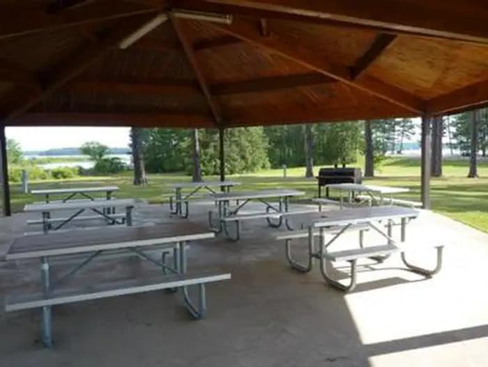
Overview Lakeside Day Use Area is situated along the banks of the Lake O' the Pines in the Ark-La-Tex portion of the Pineywoods of east Texas near the states of Arkansas, Oklahoma, and Louisiana. Address to get here: 5177 FM 726, Jefferson, TX 75657 Recreation Boating, fishing, water sports, and wildlife viewing are all popular pastimes at the campground. Hunting opportunities for white-tailed deer, waterfowl, and small game are available on nearby public lands. Lake O' the Pines fishing includes largemouth, spotted, and white bass along with crappie, catfish, and sunfish. In addition to boat fishing there are areas for bank fishing along the shore and below the dam along Big Cypress Bayou. Birdwatchers are also encouraged to bring their binoculars as numerous resident and migratory bird species inhabit the area. Bald eagle sightings are a common occurrence in fall and winter and they are occasionally sighted in spring and summer. Facilities Boating, fishing, water sports, and wildlife viewing are all popular pastimes at the campground. Hunting opportunities for white-tailed deer, waterfowl, and small game are available on nearby public lands. Lake O' the Pines fishing includes largemouth, spotted, and white bass along with crappie, catfish, and sunfish. In addition to boat fishing there are areas for bank fishing along the shore and below the dam along Big Cypress Bayou. Birdwatchers are also encouraged to bring their binoculars as numerous resident and migratory bird species inhabit the area. Bald eagle sightings are a common occurrence in fall and winter and they are occasionally sighted in spring and summer. Natural Features Lakeside Day use is located near the Ferrell's Bridge Dam. Lake O' the Pines includes about 18,700 acres of water and 9,000 acres of land. The lake was created by the construction of the Ferrell's Bridge Dam on the Big Cypress Bayou. The reservoir was originally created as part of the overall plan for flood control in the Red River Basin below Denison Dam in Oklahoma, and has now become a recreational oasis for outdoor enthusiasts. Nearby Attractions Other historic and tourist attractions are nearby in the towns of Jefferson and Marshall, and Texas Wildflower Trail routes are located along the roads surrounding the lake.
View details →
Overview Brushy Creek Day Use Area is situated along the banks of Lake O' the Pines in the Ark-La-Tex portion of the Pineywoods of east Texas near the states of Arkansas, Oklahoma, and Louisiana. Address to get here: 189 Brushy Creek Park Rd. Jefferson, TX 75657 Recreation Boating, fishing, water sports, and wildlife viewing are all popular pastimes at the campground. Hunting opportunities for white-tailed deer, waterfowl, and small game are available on nearby public lands. Lake O' the Pines fishing includes largemouth, spotted, and white bass along with crappie, catfish, and sunfish. In addition to boat fishing there are areas for bank fishing along the shore and below the dam along Big Cypress Bayou. Birdwatchers are also encouraged to bring their binoculars as numerous resident and migratory bird species inhabit the area. Bald eagle sightings are a common occurrence in fall and winter and they are occasionally sighted in spring and summer. Boating, fishing, hunting and wildlife viewing are all popular pastimes at Brushy Creek. Facilities Boating, fishing, water sports, and wildlife viewing are all popular pastimes at the campground. Hunting opportunities for white-tailed deer, waterfowl, and small game are available on nearby public lands. Lake O' the Pines fishing includes largemouth, spotted, and white bass along with crappie, catfish, and sunfish. In addition to boat fishing there are areas for bank fishing along the shore and below the dam along Big Cypress Bayou. Birdwatchers are also encouraged to bring their binoculars as numerous resident and migratory bird species inhabit the area. Bald eagle sightings are a common occurrence in fall and winter and they are occasionally sighted in spring and summer. Boating, fishing, hunting and wildlife viewing are all popular pastimes at Brushy Creek. Natural Features Lake O' the Pines includes about 18,700 acres of water and 9,000 acres of land. The lake was created by the construction of the Ferrell's Bridge Dam on the Big Cypress Bayou. The reservoir was originally created as part of the overall plan for flood control in the Red River Basin below Denison Dam in Oklahoma, and has now become a recreational oasis for outdoor enthusiasts. Nearby Attractions Other historic and tourist attractions are nearby in the towns of Jefferson and Marshall, and Texas Wildflower Trail routes are located along the roads surrounding the lake.
View details →
Overview Johnson Creek Day Use Area is situated along the banks of the Lake O' the Pines in the Ark-La-Tex portion of the Pineywoods of east Texas near the states of Arkansas, Oklahoma, and Louisiana. Address to get here: 580 Crestwood Lp. Avinger, TX 75657 Recreation Boating, fishing, water sports, and wildlife viewing are all popular pastimes at the campground. Hunting opportunities for white-tailed deer, waterfowl, and small game are available on nearby public lands. Lake O' the Pines fishing includes largemouth, spotted, and white bass along with crappie, catfish, and sunfish. In addition to boat fishing there are areas for bank fishing along the shore and below the dam along Big Cypress Bayou. Birdwatchers are also encouraged to bring their binoculars as numerous resident and migratory bird species inhabit the area. Bald eagle sightings are a common occurrence in fall and winter and they are occasionally sighted in spring and summer. best waterfowl hunting in East Texas. Facilities Boating, fishing, water sports, and wildlife viewing are all popular pastimes at the campground. Hunting opportunities for white-tailed deer, waterfowl, and small game are available on nearby public lands. Lake O' the Pines fishing includes largemouth, spotted, and white bass along with crappie, catfish, and sunfish. In addition to boat fishing there are areas for bank fishing along the shore and below the dam along Big Cypress Bayou. Birdwatchers are also encouraged to bring their binoculars as numerous resident and migratory bird species inhabit the area. Bald eagle sightings are a common occurrence in fall and winter and they are occasionally sighted in spring and summer. best waterfowl hunting in East Texas. Natural Features Lake O' the Pines includes about 18,700 acres of water and 9,000 acres of land. The Johnson Creek Day Use Area is located near the confluence of Johnson Creek and Lake O' the Pines. The lake was created by the construction of the Ferrell's Bridge Dam on the Big Cypress Bayou. The reservoir was originally created as part of the overall plan for flood control in the Red River Basin below Denison Dam in Oklahoma, and has now become a recreational oasis for outdoor enthusiasts. Nearby Attractions Other historic and tourist attractions are nearby in the towns of Jefferson and Marshall, and Texas Wildflower Trail routes are located along the roads surrounding the lake.
View details →
Overview The Juniper Point Campground is located on Lake Texoma, in the Cross Timbers region of Texas. The lake is said to be the "Playground of the Southwest," where outdoor activities like fishing, boating, hiking and hunting abound. Recreation Lake Texoma is a large reservoir with an excellent fishery and many access points. Boating, swimming, water skiing, hunting, birding and relaxing on the sandy beaches are the typical pursuits of most visitors. The lake is known as the "Striper Capital of the World," one of the few reservoirs in the nation where striped bass reproduce naturally. Other popular species include largemouth and smallmouth bass, white bass, hybrid striped bass, white crappie, black crappie, channel catfish and blue catfish. Also available is the scenic Cross Timbers hiking trail, a very popular trail that winds for 14 miles above the lake on rocky ledges and through blackjack woodland. Forty miles of equestrian trails surround the lake as well. Facilities Lake Texoma is a large reservoir with an excellent fishery and many access points. Boating, swimming, water skiing, hunting, birding and relaxing on the sandy beaches are the typical pursuits of most visitors. The lake is known as the "Striper Capital of the World," one of the few reservoirs in the nation where striped bass reproduce naturally. Other popular species include largemouth and smallmouth bass, white bass, hybrid striped bass, white crappie, black crappie, channel catfish and blue catfish. Also available is the scenic Cross Timbers hiking trail, a very popular trail that winds for 14 miles above the lake on rocky ledges and through blackjack woodland. Forty miles of equestrian trails surround the lake as well. Natural Features The campground is situated on the Texas side of Lake Texoma. Post and blackjack oaks forest the rolling hills of the region. Deer, turkeys, bobcats, hawks, waterfowl and songbirds are abundant around the lake. Nearby Attractions The lake features two wildlife refuges, two state parks and 23 commercial concession areas dedicated to the enjoyment of over six million visitors annually.
View details →
Overview Pat Mayse West Campground is on the banks of its namesake lake in the Red River Basin in Lamar County, Texas. Easy access to developed park areas has made the lake a haven for families who enjoy camping, picnicking, swimming, boating, fishing and other outdoor recreation. Recreation The lake provides excellent opportunities for boating, swimming, and fishing. Anglers will find largemouth bass, white crappie, sunfish, striped bass and channel and flathead catfish, among other species. Hunting is a very popular activity in the area. The surrounding lands are managed for upland game and whitetail deer. Other species present include fox squirrel, gray squirrel, bobwhite quail, mourning dove, cottontail rabbit, raccoon and fox. Opossum, beaver, mink, skunk and nutria are also present. The lake also provides resting and feeding habitats for migratory waterfowl. A few miles north of the project area are the famed Red River Bottoms where waterfowl congregate in impressive numbers. Facilities The lake provides excellent opportunities for boating, swimming, and fishing. Anglers will find largemouth bass, white crappie, sunfish, striped bass and channel and flathead catfish, among other species. Hunting is a very popular activity in the area. The surrounding lands are managed for upland game and whitetail deer. Other species present include fox squirrel, gray squirrel, bobwhite quail, mourning dove, cottontail rabbit, raccoon and fox. Opossum, beaver, mink, skunk and nutria are also present. The lake also provides resting and feeding habitats for migratory waterfowl. A few miles north of the project area are the famed Red River Bottoms where waterfowl congregate in impressive numbers. Natural Features Pat Mayse Lake covers almost 6,000 acres and has 67 miles of shoreline. It is situated among gently rolling grasslands and mixed hardwood forests studded with mature pines. Wildlife is abundant in the surrounding area.
View details →
Overview Platter Flats Campground is located on Lake Texoma in Oklahoma's Cross Timbers Region. The lake is said to be the "Playground of the Southwest," where outdoor activities like fishing, boating, hiking and hunting abound. Recreation Lake Texoma is a large reservoir with an excellent fishery and many access points. Boating, swimming, water skiing, hunting, birding and relaxing on the sandy beaches are the typical pursuits of most visitors. The lake is known as the "Striper Capital of the World," one of the few reservoirs in the nation where striped bass reproduce naturally. Other popular species include largemouth and smallmouth bass, white bass, hybrid striped bass, white crappie, black crappie, channel catfish and blue catfish. Also available is the scenic Cross Timbers hiking trail, a very popular trail that winds for 14 miles above the lake on rocky ledges and through blackjack woodland. Forty miles of equestrian trails surround the lake as well. Facilities Lake Texoma is a large reservoir with an excellent fishery and many access points. Boating, swimming, water skiing, hunting, birding and relaxing on the sandy beaches are the typical pursuits of most visitors. The lake is known as the "Striper Capital of the World," one of the few reservoirs in the nation where striped bass reproduce naturally. Other popular species include largemouth and smallmouth bass, white bass, hybrid striped bass, white crappie, black crappie, channel catfish and blue catfish. Also available is the scenic Cross Timbers hiking trail, a very popular trail that winds for 14 miles above the lake on rocky ledges and through blackjack woodland. Forty miles of equestrian trails surround the lake as well. Natural Features The campground is situated on the eastern side of Lake Texoma. Post and blackjack oaks forest the rolling hills of the region. Deer, turkeys, bobcats, hawks, waterfowl and songbirds are abundant around the lake. Nearby Attractions The lake features two wildlife refuges, two state parks and 23 commercial concession areas dedicated to the enjoyment of over six million visitors annually.
View details →
Overview Preston Bend Campground is located on Lake Texoma, in the Cross Timbers region of Texas. The lake is said to be the "Playground of the Southwest," where outdoor activities like fishing, boating, hiking and hunting abound. Recreation Lake Texoma is a large reservoir with an excellent fishery and many access points. Boating, swimming, water skiing, hunting, birding and relaxing on the sandy beaches are the typical pursuits of most visitors. The lake is known as the "Striper Capital of the World," one of the few reservoirs in the nation where striped bass reproduce naturally. Other popular species include largemouth and smallmouth bass, white bass, hybrid striped bass, white crappie, black crappie, channel catfish and blue catfish. Also available is the scenic Cross Timbers hiking trail, a very popular trail that winds for 14 miles above the lake on rocky ledges and through blackjack woodland. Forty miles of equestrian trails surround the lake as well. Facilities Lake Texoma is a large reservoir with an excellent fishery and many access points. Boating, swimming, water skiing, hunting, birding and relaxing on the sandy beaches are the typical pursuits of most visitors. The lake is known as the "Striper Capital of the World," one of the few reservoirs in the nation where striped bass reproduce naturally. Other popular species include largemouth and smallmouth bass, white bass, hybrid striped bass, white crappie, black crappie, channel catfish and blue catfish. Also available is the scenic Cross Timbers hiking trail, a very popular trail that winds for 14 miles above the lake on rocky ledges and through blackjack woodland. Forty miles of equestrian trails surround the lake as well. Natural Features The campground is situated on the Texas side of Lake Texoma. Post and blackjack oaks forest the rolling hills of the region. Deer, turkeys, bobcats, hawks, waterfowl and songbirds are abundant around the lake. contact_info For facility specific information, please call (903) 465-4990. Nearby Attractions The lake features two wildlife refuges, two state parks and 23 commercial concession areas dedicated to the enjoyment of over six million visitors annually.
View details →
Overview Sanders Cove Campground is on the banks of Pat Mayse Lake in the Red River Basin in Lamar County, Texas. Easy access to developed park areas has made the lake a haven for families who enjoy camping, picnicking, swimming, boating, fishing and other outdoor recreation. Recreation The lake provides excellent opportunities for boating, swimming and fishing. Anglers fish for largemouth bass, white crappie, sunfish, striped bass and channel and flathead catfish, among other species. Hunting is a very popular activity in the area. The surrounding lands are managed for upland game and whitetail deer. Other species present include fox squirrel, gray squirrel, bobwhite quail, mourning dove, cottontail rabbit, raccoon and fox. Opossum, beaver, mink, skunk and nutria are also present. The lake also provides resting and feeding habitat for migratory waterfowl. A few miles north of the project area are the famed Red River Bottoms where waterfowl congregate in impressive numbers. Facilities The lake provides excellent opportunities for boating, swimming and fishing. Anglers fish for largemouth bass, white crappie, sunfish, striped bass and channel and flathead catfish, among other species. Hunting is a very popular activity in the area. The surrounding lands are managed for upland game and whitetail deer. Other species present include fox squirrel, gray squirrel, bobwhite quail, mourning dove, cottontail rabbit, raccoon and fox. Opossum, beaver, mink, skunk and nutria are also present. The lake also provides resting and feeding habitat for migratory waterfowl. A few miles north of the project area are the famed Red River Bottoms where waterfowl congregate in impressive numbers. Natural Features Pat Mayse Lake covers almost 6,000 acres and has 67 miles of shoreline. It is situated among gently rolling grasslands and mixed hardwood forests studded with mature pines. Wildlife is abundant in the surrounding area.
View details →
Overview Lofers Bend West Campground is located on Whitney Lake on the Brazos River in Central Texas. Over two million people visit Whitney Lake each year to enjoy the plethora of recreational activities and scenic beauty the lake provides. Recreation Boating, fishing, swimming, canoeing and kayaking are popular activities at Whitney Lake. Anglers can fish for a variety of bass, crappie and catfish. Facilities Boating, fishing, swimming, canoeing and kayaking are popular activities at Whitney Lake. Anglers can fish for a variety of bass, crappie and catfish. Natural Features The park is situated on the lakeshore among rolling hills covered with cedar, live, and post oak trees. Many deer like to enjoy their stay at Lofers West along with the racoons and foxes. Nearby Attractions
View details →
Overview Ebenezer Park features some of the most beautiful horseback riding trails in southeast Texas. It's the only Army Corps of Engineers park on Sam Rayburn Reservoir with equestrian campsites, making it the go-to destination for horse-owners. The horse trail terrain is soft and sandy, so horseshoes are not required. Trails glide over rolling hills through creeks and gullies. Some trails even have beach access, allowing riders and their horses to cool off on a hot day. Note: The horse access beach and majority of the trail system are located on USFS property. Recreation In addition to horseback riding, activities include fishing, picnicking and swimming. Birding is also rewarding, with chances to see resident wood ducks and migratory birds on their journey to and from the Gulf Coast. Facilities In addition to horseback riding, activities include fishing, picnicking and swimming. Birding is also rewarding, with chances to see resident wood ducks and migratory birds on their journey to and from the Gulf Coast. Natural Features The campground, near the Sam Rayburn Dam, is fully shaded by towering pine trees. The lake is located deep in the woods, bordered by the Angelina National Forest and near the Sabine National Forest. Nearby Attractions The 20,700-acre Bannister Wildlife Management Area is on the northern peninsula of the lake. Here, hikers and bikers can explore the designated Eastern Wild Turkey restoration site.
View details →
Overview Malden Lake Campground is situated on the shore of 30,000-acre Wright Patman Lake within the piney woods of northeast Texas. This facility offers year-round enjoyment of outdoor activities like fishing, hunting and wildlife viewing. Recreation Wright Patman Lake hosts a wide range of recreational activities, including camping, swimming, boating, fishing, hunting, hiking, picnicking and wildlife viewing. Boaters flock to the lake, and anglers try their luck for bass, catfish, crappie and sunfish. Malden Lake Park has a trail system behind the campsites in the H Loop, which is great for walking and enjoying the the park. Facilities Wright Patman Lake hosts a wide range of recreational activities, including camping, swimming, boating, fishing, hunting, hiking, picnicking and wildlife viewing. Boaters flock to the lake, and anglers try their luck for bass, catfish, crappie and sunfish. Malden Lake Park has a trail system behind the campsites in the H Loop, which is great for walking and enjoying the the park. Natural Features The campground overlooks the lake and is set among a thick pine forest that provides plenty of shade. The U.S. Army Corps of Engineers manages approximately 55,000 acres of public forestland around the lake, providing habitat for wild turkey, bobwhite quail, squirrel, white-tailed deer, waterfowl and migrating bald eagles, pelicans and ducks. Some poisonous snakes inhabit the area. contact_info For local information, please call (903) 585-2497 or call (903) 838-8781 for general information. Nearby Attractions The Texarkana region is full of activities such as shopping, movies, restaurants and local historical sites. Shreveport, Louisiana offers river boat gambling, horse races and numerous festivals, including the Four State Fair and Rodeo and the Jump, Jive and Jam Festival.
View details →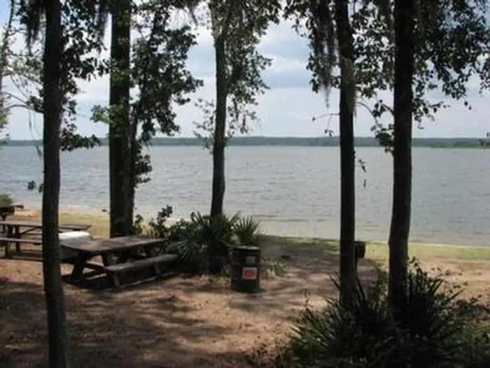
Overview Cagle Recreation Area is a popular campground and day-use area that sits along the shoreline of Lake Conroe on the west fork of the San Jacinto River, just 1 hour north of Houston, Texas. The area offers great camping, fishing, hiking, hunting, birding and water sports year-round. Recreation Anglers are drawn to the 22,000-acre Lake Conroe for its forested lake shore and open water. The lake is particularly noted for black bass and year-round fishing. Swimming is not allowed, but fishing, hiking, picnicking and shoreline wading are sure to provide plenty of fun for kids. Hikers and mountain bikers can try the 2-mile Cagle Trail within the facility. Learn more about recreation in the national forest. Facilities Anglers are drawn to the 22,000-acre Lake Conroe for its forested lake shore and open water. The lake is particularly noted for black bass and year-round fishing. Swimming is not allowed, but fishing, hiking, picnicking and shoreline wading are sure to provide plenty of fun for kids. Hikers and mountain bikers can try the 2-mile Cagle Trail within the facility. Learn more about recreation in the national forest. Natural Features Cagle is nestled among the pines of the Sam Houston National Forest. This area is covered with beautiful large pine and hardwood trees plus thousands of colorful wildflowers. Mid-February redbud tree blossoms followed by dogwood blossoms in early March put on a spectacular display of flowers. Lake Conroe and the surrounding forest provide wintering habitat for the endangered bald eagle. Temperatures are moderate to cool from September through May, and hot and humid from June to August. Winters are cool and wet. Nearby Attractions Visitors can explore the national forest's 85 miles of off-road vehicle, equestrian and mountain bike trails. The 128 mile Lone Star Hiking trail is nearby with a portion of the trail located near Lake Conroe.
View details →
Overview Chisos Basin Group Campground, situated high in the rugged Chisos Mountains, is one of the most sought-after campgrounds in Big Bend National Park. It has seven group camping sites available for groups of nine to 20 people (size is site-dependent). At an altitude of 5,400 ft. (1646 m),, the campground is surrounded on all sides by tall, rocky cliffs and conveniently located near some of the park's most spectacular and popular trails. The Rio Grande is only a short drive away. Also found in the area is the Chisos Basin Visitor Center, the General Store and the Chisos Mountains Lodge , which houses the only restaurant in Big Bend National Park. Recreation This campground is a hub for hikers. Some of the park's most spectacular and popular Day Hike trails are nearby, including the Lost Mine Trail, the Window Trail, the South Rim Trail and the Pinnacles Trail, with its access to the park's highest point, Emory Peak (elevation 7,825 ft./2385 m). Campers can find the trailheads for most of these trails in the main Chisos Basin area a mile or so further down the Basin road from the campground. Access to the river is approximately 30 miles (48 km) away, where visitors can canoe, kayak and fish. Facilities This campground is a hub for hikers. Some of the park's most spectacular and popular Day Hike trails are nearby, including the Lost Mine Trail, the Window Trail, the South Rim Trail and the Pinnacles Trail, with its access to the park's highest point, Emory Peak (elevation 7,825 ft./2385 m). Campers can find the trailheads for most of these trails in the main Chisos Basin area a mile or so further down the Basin road from the campground. Access to the river is approximately 30 miles (48 km) away, where visitors can canoe, kayak and fish. Natural Features The national park is named for a curve in the Rio Grande called the "big bend." For 1,250 miles (2012 km), the river is an International Boundary between the United States and Mexico. The campground lies at the base of several sloping cliffs amidst montane shrubland; desert plants such as Arizona cyprus and mesquite trees fill the landscape. Maple, aspen, pinyon and ponderosa pines grow at higher elevations just above the campground. Though it is lower than the surrounding cliffs, the Chisos Basin is at a higher elevation than other campgrounds within the park. Summer temperatures here are cool, yet warmer than other areas in fall and winter due to the cold air sinking into lower regions. The Chisos Mountains are a popular nesting site for migratory birds . The mountains provide the only nesting ground in the United States for the Colima Warbler, which arrives in mid-April and departs for its wintering grounds in southwestern Mexico by mid-September. Nearby Attractions Big Bend National Park encompasses 801,000 acres (324,153 ha) and the Chisos Basin area is centrally located. This allows visitors an excellent opportunity to explore all areas of the park in a relatively short drive. Big Bend offers excellent hiking trails, miles of rugged dirt roads, and endless possibilities for sightseeing.
View details →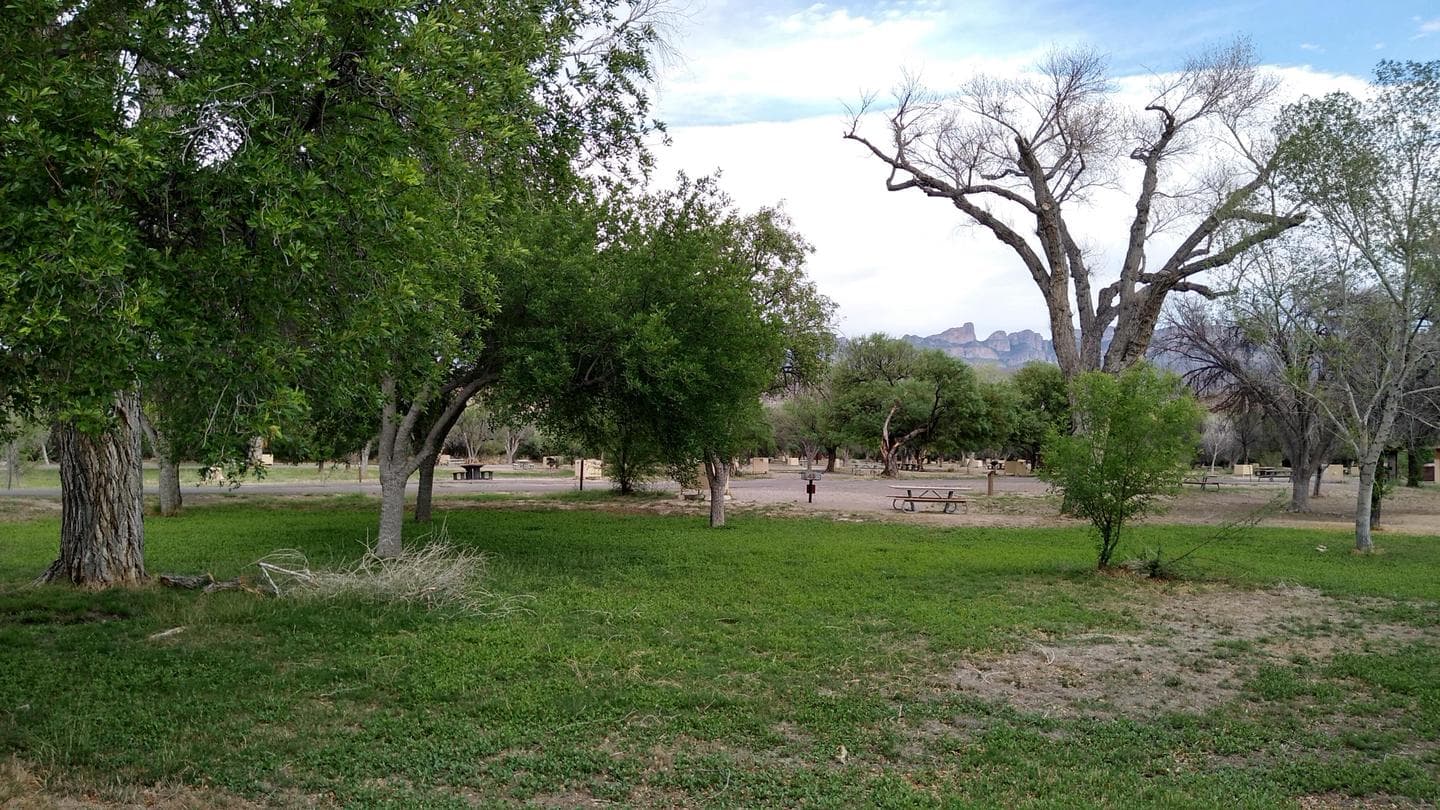
Overview The Rio Grande Village Group Campground sits on the banks of the Rio Grande, the International Boundary between the United States and Mexico. The four group campsites are great options for groups of nine people or more and is one of the most popular campgrounds in Big Bend National Park. It is located close to Boquillas Canyon and Hot Springs, and acts as a launch point for visitors accessing the river or the endless miles of backcountry roads. Rio Grande Village has an outstanding view of the Sierra del Carmen Mountains, located in Mexico to the east, which light up with hues of red and orange during sunset. Recreation The river offers ample opportunities to explore its shores and water. The river put-in allows easy access to canoeing and kayaking on the river. Birders flock to the river banks to spot such rare and unique species often found only in Big Bend. Trails for Day Hikes and many backcountry roads are located near the campground. Facilities The river offers ample opportunities to explore its shores and water. The river put-in allows easy access to canoeing and kayaking on the river. Birders flock to the river banks to spot such rare and unique species often found only in Big Bend. Trails for Day Hikes and many backcountry roads are located near the campground. Natural Features The mountain views, proximity to Mexico, the Rio, and shade from the surrounding cottonwood trees make Rio Grande Village Campground irresistible to visitors. The campground is at an elevation of 1,850 ft. During the winter season (November through March) temperatures are warm and pleasant with daily highs in the mid-70s to low 80s. From April through September, this campground is extremely HOT with daily highs exceeding 100-107 degrees. Be prepared for the weather: Current Weather Readings Nearby Attractions Rio Grande Village is located near the Boquillas Canyon trail, the Boquillas Port of Entry, the Marufo Vega Loop trail, the Hot Springs and Hot Springs Historic area and Daniels Ranch. It is 20 miles from the Panther Junction Visitor Center.
View details →
Overview The Rio Grande Village Campground sits near the banks of the Rio Grande, the International Boundary between the United States and Mexico. It is one of the most popular campgrounds in Big Bend National Park, especially for those traveling in large recreational vehicles. It is located close to Boquillas Canyon and Hot Springs, and serves as a launch point for visitors accessing the river or the endless miles of backcountry roads. Rio Grande Village has an outstanding view of the Sierra del Carmen Mountains, located in Mexico to the east, which light up with hues of red and orange during sunset. Recreation The river offers ample opportunities to explore its shores and water. The river put-in allows easy access to canoeing and kayaking on the river. Birders flock to the river banks to spot such rare and unique species often found only in Big Bend. Day Hike trails are also found nearby and many backcountry roads are located near the campground. Facilities The river offers ample opportunities to explore its shores and water. The river put-in allows easy access to canoeing and kayaking on the river. Birders flock to the river banks to spot such rare and unique species often found only in Big Bend. Day Hike trails are also found nearby and many backcountry roads are located near the campground. Natural Features The mountain views, proximity to Mexico, the Rio, and shade from the surrounding cottonwood trees make Rio Grande Village Campground irresistible to visitors. The campground is at an elevation of 1,850 ft. During the winter season (November through March) temperatures are warm and pleasant with daily highs in the mid-70s to low 80s. From April through September, this campground is extremely HOT with daily highs exceeding 100-107 degrees. Be prepared for the weather: Current Weather Readings Nearby Attractions Rio Grande Village is located near the Boquillas Canyon trail, the Boquillas Port of Entry, the Marufo Vega Loop trail, the Hot Springs and Hot Springs Historic District and Daniels Ranch. It is 20 miles (32 km) from the Panther Junction Visitor Center.
View details →
Overview Cottonwood Campground is a quiet desert oasis in the southwestern corner of Big Bend National Park. Conveniently located between the Castolon Historic District, the scenic Santa Elena Canyon and the tail end of the Ross Maxwell Scenic Drive, this small, 30-site campground is one of the least-known and quiet campgrounds in the park. There is one group campsite and 30 individual sites. This is a remote campground in a remote park. It is dry camping, no hook-ups, and no generators are permitted. There is not a fill or dump station, please come prepared. Cottonwood gets its name from the cottonwood trees that surround and provide shade for the facility nearby the Rio Grande. A general store and visitor center -- a converted former military outpost -- are also nearby. The campground is at an elevation of 1,900 ft. (580 m). It is relatively cool in the peak seasons of fall and winter due to cold air sinking into the lower elevations. In the spring and summer, this campground is very hot, with temperatures normally exceeding 100° F (38° C) from mid-March through August. Recreation Particularly popular with bird watchers, Cottonwood Campground is a haven for those wishing to study the abundant bird life in Big Bend while also escaping the more crowded areas in the park. Because of its diverse ecosystems and plant life, the park provides habitats for many rare and unique birds , including the Mexican mallard, Lucifer hummingbird, Mexican jay, black-capped and gray vireos, and Varied Bunting. Hiking trails are located around the campground. Facilities Particularly popular with bird watchers, Cottonwood Campground is a haven for those wishing to study the abundant bird life in Big Bend while also escaping the more crowded areas in the park. Because of its diverse ecosystems and plant life, the park provides habitats for many rare and unique birds , including the Mexican mallard, Lucifer hummingbird, Mexican jay, black-capped and gray vireos, and Varied Bunting. Hiking trails are located around the campground. Natural Features The national park is named for a curve in the Rio Grande called the "big bend." For 1,250 miles (2011 km), the river is an International Boundary between the United States and Mexico. Due to its proximity to water, many species of birds are in the Cottonwood area, including nesting migratory birds. Santa Elena Canyon is a beautiful river canyon that can be seen from the campground area. Nearby Attractions Santa Elena Canyon, Castolon Historic District, and Ross Maxwell Scenic Drive are near the campground.
View details →
Overview White Flint Park is located at Belton Lake, which provides some of the best fishing, camping and boating in Central Texas. This year-round campground has 12 sites with screened overnight shelters and 13 RV sites, all with water and electric hookups. Belton Lake was created by the U.S. Army Corps of Engineers with the construction of Belton Dam in 1954. The 12,300-acre lake is located on the Leon River, just upstream of the confluence of the Leon River and the Little River. Recreation With 136 miles of shoreline, Belton Lake offers a wide variety of recreation activities, including camping, water sports, picnicking and nature trails. This facility has a boat ramp, providing easy access to the water for boaters and anglers. Hawks, Great Blue herons, ducks, geese, many species of songbirds, bobwhite quail, Rio Grande turkeys and even an occasional bald eagle visit the lake area, yielding year-round opportunities for birders. Facilities With 136 miles of shoreline, Belton Lake offers a wide variety of recreation activities, including camping, water sports, picnicking and nature trails. This facility has a boat ramp, providing easy access to the water for boaters and anglers. Hawks, Great Blue herons, ducks, geese, many species of songbirds, bobwhite quail, Rio Grande turkeys and even an occasional bald eagle visit the lake area, yielding year-round opportunities for birders. Natural Features All of the campsites are along the shoreline of Belton Lake. The campground is partially forested, providing a mixture of sun and shade. There is a man-made wetland on the lake between White Flint and Winkler Parks, providing an additional 25 acres of wildlife habitat in the lake area. contact_info For facility specific information, please call (254) 742-3050. Nearby Attractions Belton Lake is located adjacent to the Fort Hood Army Base, which has several points of interest for the military buff. The mural painted on the spillway wall of Belton Dam depicts the history of the Bell County area.
View details →
Overview Ratcliff Lake Recreation Area was built in 1936 by the Civilian Conservation Corps. It surrounds a picturesque 45-acre lake that was once a log pond and a source of water for the Central Coal and Coke Company sawmill which operated from 1902 to 1920. The facility is open year-round and includes a large campground, picnic areas, a reservable amphitheater, a swim area and many opportunities for outdoor recreation. Camping is available year-round. The Davy Crockett National Forest, named for the legendary pioneer, contains more than 160,000 acres of East Texas woodlands, streams, recreation areas and wildlife habitat. Located in Houston and Trinity Counties, the forest is centrally located within the Neches and Trinity River basins. Recreation Swimming, fishing, hunting, hiking and picnicking are the area's main activities. The designated swimming area and playground provides much fun for the kids (no lifeguard on duty). Fishing piers are available for anglers to try for largemouth bass, bream and channel/blue catfish. Only electric motors are allowed on the lake. Principal game for hunting on the national forest includes squirrel, deer, quail, dove, turkey and waterfowl. Three main hiking trails can be accessed from the facility: the 1.5-mile Tall Pines, 0.75-mile Trail Tamers and the 20-mile Four C, which winds through many types of forests to a scenic overlook. Learn more about recreation in the national forest. Facilities Swimming, fishing, hunting, hiking and picnicking are the area's main activities. The designated swimming area and playground provides much fun for the kids (no lifeguard on duty). Fishing piers are available for anglers to try for largemouth bass, bream and channel/blue catfish. Only electric motors are allowed on the lake. Principal game for hunting on the national forest includes squirrel, deer, quail, dove, turkey and waterfowl. Three main hiking trails can be accessed from the facility: the 1.5-mile Tall Pines, 0.75-mile Trail Tamers and the 20-mile Four C, which winds through many types of forests to a scenic overlook. Learn more about recreation in the national forest. Natural Features The campground is heavily forested with loblolly pine, oak and other hardwoods, and surrounds Ratcliff Lake. A wide variety of wildlife exists in the area, including the endangered red-cockaded woodpecker. Nearby Attractions The Big Slough Wilderness Area, located along the Neches River about five miles north of Ratcliff, is free of modern development and gives the visitor a place for solitude and primitive experiences.
View details →
Overview Lakeland Pavilion is a pleasant picnic pavilion and large group campground accommodating up to 500 visitors for picnicking, boating and fishing on Lavon Lake. Recreation Lavon Lake's most common catches include largemouth bass, white bass, blue catfish and crappie. Equestrian and hiking on nearby Trinity Trail is a great way to explore the area. Facilities Lavon Lake's most common catches include largemouth bass, white bass, blue catfish and crappie. Equestrian and hiking on nearby Trinity Trail is a great way to explore the area. Natural Features The pavilion is in Lakeland Park on the eastern shores of Lavon Lake. Lavon Lake, in northern Texas, flows from the East Fork tributary of the Trinity River. Its surface area is 21,400 acres and the maximum lake depth is around 59 ft.. Nearby Attractions The Heard Natural Science Museum and Wildlife Sanctuary in nearby McKinney, features natural history exhibits and nature trails.
View details →
Overview Russell Park is located on the west side of Georgetown Lake, in the Texas Hill Country approximately 25 miles north of Austin. Visitors enjoy boating, fishing and exploring the San Gabriel River Trail. Recreation Boating is the most popular way to enjoy the lake, and a boat ramp is provided for guests. Fishing is excellent in the area, and the lake contains black bass, white bass, hybrid stripers, white crappie and channel and flathead catfish, but it's most known for its abundance of smallmouth bass. Fishing docks are located on the shore within the campground. The San Gabriel River Trail is a 26-mile rugged path winding through dense juniper forest, hardwood bottomlands and prairie grasslands. The trail extends completely around Georgetown Lake via the dam and is open to hiking and biking. Hunting is available for small game species such as dove, waterfowl, rabbit and squirrel, as well as white-tailed deer. Hunting is by permit only. Facilities Boating is the most popular way to enjoy the lake, and a boat ramp is provided for guests. Fishing is excellent in the area, and the lake contains black bass, white bass, hybrid stripers, white crappie and channel and flathead catfish, but it's most known for its abundance of smallmouth bass. Fishing docks are located on the shore within the campground. The San Gabriel River Trail is a 26-mile rugged path winding through dense juniper forest, hardwood bottomlands and prairie grasslands. The trail extends completely around Georgetown Lake via the dam and is open to hiking and biking. Hunting is available for small game species such as dove, waterfowl, rabbit and squirrel, as well as white-tailed deer. Hunting is by permit only. Natural Features Georgetown Lake is a reservoir on the North Fork San Gabriel River in central Texas. The dam was completed in 1979 to provide flood control and water supply for the nearby community of Georgetown, and now provides countless recreation opportunities for outdoor enthusiasts. Nearby Attractions The nearby town of Georgetown offers gas, groceries and more. The historic downtown square district has shops and restaurants, and concerts and events are held on a regular basis. Additionally, Austin is located just 25 miles from the lake, offering countless tourist attractions. Charges & Cancellations Cancellations: Once a reservation date has begun, customers cannot change a reservation using the online system or through the Call Center. On-site personnel are not able to modify reservations. Individual Campsites: Cancellations up to 2 days before a reservation start date incur a $10.00 cancellation fee. A customer who cancels a reservation the day before or on the day of arrival will pay a $10.00 service fee AND forfeit the first night's use fee (not to exceed the total paid for the original reservation). Cancellations for a one-night reservation will forfeit the entire amount paid and will not be subject to an additional service fee. Group Facility (including Cabins and Lookouts): Customers who cancel a group overnight facility reservation less than 14 days before the arrival date will pay a $10.00 service fee AND forfeit the first night's use fee. Group Day Use Area: Customers who cancel a group day-use facility reservation less than 14 days before the arrival date will forfeit the total day-use fee. Refunds: Customers can request refunds online up to 7 days after the scheduled departure date. After 7 days, customers must request refunds through the call center. Cancellation fees are non-refundable.
View details →
Overview Rocky Creek Park is on the east side of Benbrook Lake in north central Texas, accessible form Granbury Road or McPherson Road. Picnicking, camping, hiking & horseback trails, boat launch, and fishing are available. Recreation Picnicking, fishing, boating, hiking and birding are all available in the Rocky Creek Park Primitive, seasonal camping may be available. Facilities Picnicking, fishing, boating, hiking and birding are all available in the Rocky Creek Park Primitive, seasonal camping may be available. Natural Features The park is on the east side of wooded Rocky Creek. The main picnic area lies on an open peninsula below wooded hillsides. The wooded campground is up the creek. Nearby Attractions Fort Worth's renowned Cultural & Museum District, Stockyards National Historic District, Botanical Gardens, Zoo, Bass Performance Hall, and downtown Sundance Square are all only as hort drive.
View details →
Overview The Pine Springs RV campground is not a traditional campground. Be aware, this is a paved parking lot. The area shares a popular and busy trailhead accessing four major trails. The area is frequently congested with day use hikers searching for available parking and with foot traffic from overflow parking areas. Before booking a reservation: It is your responsibility to review all (Site Details, Allowable Equipment, Allowable Vehicle/Driveway and Need to Know) for the individual campsite. Failing to do so may result in being prohibited from occupying the site upon your arrival. Refunds are not provided by the park. Pine Springs Campground is located near the Pine Springs Visitor Center, just off U.S. 62/180 and at an elevation of 5,730 feet. The location offers great hiker access to the Guadalupe Mountains National Park trail system. The campground is situated at the opening to the Pine Springs Canyon with spectacular views of the world’s best example of a fossil reef and of the vast Permian Basin to the east. The campground is open year-round and is busiest, March-May and September-November. High winds with over 50 mph gusts are common, especially during winter and spring. Recreation The Pine Springs Trailhead includes access to many different types of hikes. Hikes to Guadalupe Peak or the Bowl are strenuous, 8-9 miles, and have 2500-3000 feet of elevation gain. Another strenuous hike is the Devil’s Hall Trail (4.2 miles round-trip, 500 feet elevation gain, ½ of the trail in a rocky, uneven wash which includes route-finding and boldering skills). For a more moderate hike consider the the Frijole/Foothills Trail. The El Capitan Trail offers excellent open views of the surrounding desert and close approaches to the cliff face of El Capitan. Because of its distance, lack of shade, some primitive route travel, and numerous elevation changes, this trail is best saved for cooler times of year and for people with experience in route-finding. The ruins of a Butterfield stage station, called the Pinery are next to the highway, and a short, paved nature trail connects the visitor center and the historic site. The Frijole Ranch & History Museum is 1.5 miles away. The grounds are always open, but the museum is staffed intermittently. Seven miles to the east on Hwy 62/180 is McKittrick Canyon. This area offers three trails, the McKittrick Canyon Nature Trail (0.9 miles loop), McKittrick Canyon Trail (4.8 miles round-trip to Pratt Cabin or 6.8 miles round-trip to the Grotto) and the Permian Reef Trail (8.4 miles round-trip, for serious geology buffs). Facilities The Pine Springs Trailhead includes access to many different types of hikes. Hikes to Guadalupe Peak or the Bowl are strenuous, 8-9 miles, and have 2500-3000 feet of elevation gain. Another strenuous hike is the Devil’s Hall Trail (4.2 miles round-trip, 500 feet elevation gain, ½ of the trail in a rocky, uneven wash which includes route-finding and boldering skills). For a more moderate hike consider the the Frijole/Foothills Trail. The El Capitan Trail offers excellent open views of the surrounding desert and close approaches to the cliff face of El Capitan. Because of its distance, lack of shade, some primitive route travel, and numerous elevation changes, this trail is best saved for cooler times of year and for people with experience in route-finding. The ruins of a Butterfield stage station, called the Pinery are next to the highway, and a short, paved nature trail connects the visitor center and the historic site. The Frijole Ranch & History Museum is 1.5 miles away. The grounds are always open, but the museum is staffed intermittently. Seven miles to the east on Hwy 62/180 is McKittrick Canyon. This area offers three trails, the McKittrick Canyon Nature Trail (0.9 miles loop), McKittrick Canyon Trail (4.8 miles round-trip to Pratt Cabin or 6.8 miles round-trip to the Grotto) and the Permian Reef Trail (8.4 miles round-trip, for serious geology buffs). Natural Features The Pine Springs Campground is in an area with small, scattered trees, shrubs, and grasses. Trees include gray oaks and alligator junipers, which cast partial shade at some sites. Texas madrones, bigtooth maples, chinquapin oaks, and ponderosa pines become more common along the canyon floor. Higher elevations include Douglas fir and hop-hornbeam. Shrubs include whitethorn acacia, Mexican orange, Apache plume, sumacs, and algerita. Desert-adapted plants also occur in this area, and include prickly pear cactus, New Mexico agave, sotols, and soaptree yuccas. Hunter Peak and cross-sectional views of the Capitan reef are visible from the campground. Roadside pullouts (one mile and four miles away) provide excellent views of El Capitan. Hiking into Pine Springs canyon or along the foothills reveals Guadalupe Peak. The Guadalupe Peak trail ascends to the highest point in Texas and offers excellent views of the surrounding desert. Birds commonly seen and/or heard around the campground can include Canyon towhees, turkey vultures, white-winged doves, common ravens, chipping sparrows, Say’s phoebes, common poorwills, and phainopeplas depending on the season. Night sky visibility is excellent and nearly pristine directly overhead, to the south, and the southwest. Nearby high ridges and peaks are situated to the west and north. Nearby Attractions Carlsbad Caverns National Park: In addition to a variety of cave tours, the national park also offers hiking trails and a scenic drive. Rattlesnake Springs and Slaughter Canyon, part of Carlsbad Caverns are nearer attractions for day use activities. Birding is excellent at Rattlesnake Springs. Lincoln National Forest: The Guadalupe District of the Lincoln National Forest is located just over the state line, north of the national park. Road access is through New Mexico, north of White’s City, via Dark Canyon Road to NM SR 137 through Queen (also the way to the national park’s Dog Canyon). The forest provides for various camping, hiking, caving, hunting, and picnicking opportunities. Sitting Bull Falls is a nice waterfall and picnic area in the Lincoln National Forest. Five Point Vista is a glorious ridge road ride of the area, closer to Dog Canyon. Fort Davis National Historic Site and State Park: Fort Davis is one of the best surviving examples of an Indian Wars' frontier military post in the Southwest. From 1854 to 1891, Fort Davis was strategically located to protect emigrants, mail coaches, and freight wagons on the Trans-Pecos portion of the San Antonio-El Paso Road and on the Chihuahua Trail. This is located about 2.5 hours south of the park. A state park is located nearby with camping and a scenic drive. Also located in Fort Davis is McDonald Observatory with several programs available. White Sands National Park: Rising from the heart of the Tularosa Basin is one of the world's great natural wonders - the glistening white sands of New Mexico. Great wave-like dunes of gypsum sand have engulfed 275 square miles of desert, creating the world's largest gypsum dunefield. White Sands National Park preserves a major portion of this unique dunefield, along with the plants and animals that live here. Hueco Tanks State Park & Historic Site: Hueco Tanks State Park is located on the east side of El Paso, about an hour and a half from the Guadalupes. At Hueco Tanks, you can hike, rock climb, bird watch, study nature and history, picnic and stargaze. Visitors can take guided and self-guided tours to view rock imagery. Charges & Cancellations Individual Site: A $10.00 service fee will apply if you modify your reservation or change your stay dates. Cancelling your reservation prior to 11:59 p.m. Eastern Time two nights before your stay will incur a $10.00 cancellation fee. Camping reservations cancelled the day before and day of arrival incur a $10 cancellation fee and forfeit the first night's use fee. If you need to cancel or modify your reservation, you must do so through Recreation.gov. Group Site: Customers who cancel a group overnight reservation less than 14 days before the arrival date will pay a $10.00 service fee & forfeit the first night's use fee.
View details →
Overview Dog Canyon is a 70-mile drive from the nearest town of Carlsbad, New Mexico and is 110 miles from the Pine Spring Visitor Center & Campground (a 2 hour drive time). Before booking a reservation: It is your responsibility to review all (Site Details, Allowable Equipment, Allowable Vehicle/Driveway and Need to Know) for the individual campsite. Failing to do so may result in being prohibited from occupying the site upon your arrival. Refunds are not provided by the park. Dog Canyon Campground lies in the secluded, forested canyon on the north side of Guadalupe Mountains National Park at an elevation of 6,300 feet. It is located at the end of NM Hwy. 137 (Queen Highway). This quiet location is great for relaxing, wildlife watching and hiking. The campground is open year-round and is busiest, March-May and September-November. Recreation Trails from Dog Canyon offer good access, with relatively easy grades, to the high country of Guadalupe Mountains National Park. The hike to Lost Peak is 6.4 miles round-trip, is considered strenuos and has 1500’ elevation gain. The hike to Marcus Overlook is 4.5 miles round-trip, is considered moderate with an 800' elevation gain. The Indian Meadow Nature Trail near the campground is 0.6 miles and winds around a grassy area surrounded by a mix of broadleaved evergreens, deciduous trees, and pines. Facilities Trails from Dog Canyon offer good access, with relatively easy grades, to the high country of Guadalupe Mountains National Park. The hike to Lost Peak is 6.4 miles round-trip, is considered strenuos and has 1500’ elevation gain. The hike to Marcus Overlook is 4.5 miles round-trip, is considered moderate with an 800' elevation gain. The Indian Meadow Nature Trail near the campground is 0.6 miles and winds around a grassy area surrounded by a mix of broadleaved evergreens, deciduous trees, and pines. Natural Features The Dog Canyon Campground is in an area with wooded drainages, meadows, and grassy hillsides and sparsely vegetated outcrops. Large alligator junipers, oaks, maples, madrones, piñon and ponderosa pine are in and near the campground. Shrubs include ceanothus, sumacs, mahonia, and mountain mahogany. Desert-adapted plants include a variety of prickly pear cactus, agave, and chollas. Western scrub jays, acorn woodpeckers, and a variety of hummingbirds frequent the area. Mule deer are commonly seen. Algerita ridge casts morning shade, and cool mountain air settles in the canyon bottom nightly. Daytime highs are similar to the Pine Springs area, but nighttime lows can be much cooler. Views of the night sky are pristine. During the Permian Period, shallow marine water that was behind the Capitan Reef, created a series of layers of limestone and sandstone. Faulting and subsequent erosion created the canyon. Nearby topographic features include Lost Peak, Blue Ridge, West Dog Canyon, and the Brokeoff and Cutoff Mountains. contact_info This location has limited staffing. Please call (915) 828-3251 for general information. Nearby Attractions Carlsbad Caverns National Park: In addition to a variety of cave tours, the national park also offers hiking trails and a scenic drive. Rattlesnake Springs and Slaughter Canyon, part of Carlsbad Caverns are nearer attractions for day use activities. Birding is excellent at Rattlesnake Springs. Lincoln National Forest: The Guadalupe District of the Lincoln National Forest is located just over the state line, north of the national park. Road access is through New Mexico, north of White’s City, via Dark Canyon Road to NM SR 137 through Queen (also the way to the national park’s Dog Canyon). The forest provides for various camping, hiking, caving, hunting, and picnicking opportunities. Sitting Bull Falls is a nice waterfall and picnic area in the Lincoln National Forest. Five Point Vista is a glorious ridge road ride of the area, closer to Dog Canyon. Fort Davis National Historic Site and State Park: Fort Davis is one of the best surviving examples of an Indian Wars' frontier military post in the Southwest. From 1854 to 1891, Fort Davis was strategically located to protect emigrants, mail coaches, and freight wagons on the Trans-Pecos portion of the San Antonio-El Paso Road and on the Chihuahua Trail. This is located about 2.5 hours south of the park. A state park is located nearby with camping and a scenic drive. Also located in Fort Davis is McDonald Observatory with several programs available. White Sands National Park: Rising from the heart of the Tularosa Basin is one of the world's great natural wonders - the glistening white sands of New Mexico. Great wave-like dunes of gypsum sand have engulfed 275 square miles of desert, creating the world's largest gypsum dunefield. White Sands National Park preserves a major portion of this unique dunefield, along with the plants and animals that live here. Hueco Tanks State Park & Historic Site: Hueco Tanks State Park is located on the east side of El Paso, about an hour and a half from the Guadalupes. At Hueco Tanks, you can hike, rock climb, bird watch, study nature and history, picnic and stargaze. Visitors can take guided and self-guided tours to view rock imagery. Charges & Cancellations Individual Site: A $10.00 service fee will apply if you modify your reservation or change your stay dates. Cancelling your reservation prior to 11:59 p.m. Eastern Time two nights before your stay will incur a $10.00 cancellation fee. Camping reservations cancelled the day before and day of arrival incur a $10 cancellation fee and forfeit the first night's use fee. If you need to cancel or modify your reservation, you must do so through Recreation.gov. Group Site: Customers who cancel a group overnight reservation less than 14 days before the arrival date will pay a $10.00 service fee & forfeit the first night's use fee.
View details →FAQ
Camping in Texas
How many campgrounds are listed in Texas?
TheCampVerse currently lists 72 campgrounds in Texas.
What campground types are most common in Texas?
The most common campground types are Campground.
How can I compare campgrounds in Texas?
Use the campground cards and featured links on this page to compare descriptions, amenities, and details before opening each campground profile.
Keep exploring