
Campgrounds Near Mount Rainier
An active volcano draped in glaciers, surrounded by old-growth forest and wildflower meadows.
40
Campgrounds within 50 mi
Washington
Primary state
6 mi
Closest campground
Nearby campgrounds
40 campgrounds within 50 miles of Mount Rainier

WA · Campground
Overview Cougar Rock Campground, on the southwest side of Mt. Rainier National Park, is conveniently located near Paradise. Individual campsites are reservable on this page. Group campsite reservations can be made via Cougar Rock Group Campground . Paradise is the most popular destination in the park, with a lodge and visitor center, many miles of hiking trails and a commanding view of the mountain-the highest in the state and Cascade range. The main attraction at Mount Rainier National Park is the mountain itself, a massive glacier-clad volcano, peaking at 14,411 ft. and dominating the skyline for hundreds of miles. Visitors travel through majestic old-growth forests, past tumbling waterfalls and historic buildings to reach sub-alpine meadows, where world-famous wildflower displays bloom through July and August. Popular activities in the park include sight-seeing, hiking, rock climbing and camping. Cougar Rock campground is located at an elevation of 3,180 feet. Summers are dry and cool with daytime temperatures ranging from 60 to 80 degrees. Weather throughout the park can be variable, so visitors should come prepared. Recreation From the facility, experienced hikers and backpackers can access the well-known, strenuous and beautiful Wonderland Trail, which encircles the park for 93 miles. For those who enjoy learning more about the park's natural and cultural history, there is an on-site amphitheater where interpretive programs are held. Facilities From the facility, experienced hikers and backpackers can access the well-known, strenuous and beautiful Wonderland Trail, which encircles the park for 93 miles. For those who enjoy learning more about the park's natural and cultural history, there is an on-site amphitheater where interpretive programs are held. Natural Features Cougar Rock Campground has one lookout point from which campers can view Mt. Rainier. Although it is peaceful now, the still active volcano last erupted in the mid 1800s. The campground is adjacent to the Nisqually River and is surrounded by thick forests. A short drive to Paradise in summer reveals fields of lush wildflowers. Nearby Attractions Mount Rainier National Park is about 50 miles southeast of the Seattle-Tacoma metropolitan area. Charges & Cancellations If a camper does not check-in at the ranger station by 12:00pm check-out time the day after the scheduled arrival date, their reservation will be cancelled, the camper will incur a $10.00 service fee, and forfeit the first night's camping fee.
View details →
Overview Cougar Rock Group Campground, on the southwest side of Mt. Rainier National Park, is conveniently located near Paradise. Group campsite reservations can be made on this page. Individual campsites are reservable via Cougar Rock Campground. Paradise is the most popular destination in the park, with a lodge and visitor center, many miles of hiking trails and a commanding view of the mountain. The main attraction at Mount Rainier National Park is the mountain itself, a glacier-clad volcano of immense proportions. At 14,411 feet, it dominates the skyline for hundreds of miles. Visitors travel through majestic old-growth forest, past tumbling waterfalls and historic buildings to reach sub-alpine meadows, where world-famous wildflower displays are seen through July and August. Popular activities in the park include sight-seeing, hiking, rock climbing and camping. The Cougar Rock area is located at an elevation of 3,180 feet. Summers are dry and cool with daytime temperatures in the 60 to 80-degree range. Weather throughout the park can be variable, so visitors should come prepared. Recreation From the facility, experienced hikers and backpackers can access the well-known, strenuous but beautiful Wonderland Trail, which encircles the park for 93 miles. For those who enjoy learning more about the park's natural and cultural history, there is an on-site amphitheater where interpretive programs are held. Facilities From the facility, experienced hikers and backpackers can access the well-known, strenuous but beautiful Wonderland Trail, which encircles the park for 93 miles. For those who enjoy learning more about the park's natural and cultural history, there is an on-site amphitheater where interpretive programs are held. Natural Features The campground has one lookout point from which campers can view Mt. Rainier. Although it is peaceful now, the still-active volcano last erupted in the mid 1800s. The campground is adjacent to the Nisqually River and is surrounded by thick forests. A short drive to Paradise in summer reveals fields of lush wildflowers. Nearby Attractions Mount Rainier National Park is about 50 miles southeast of the Seattle-Tacoma metropolitan area.
View details →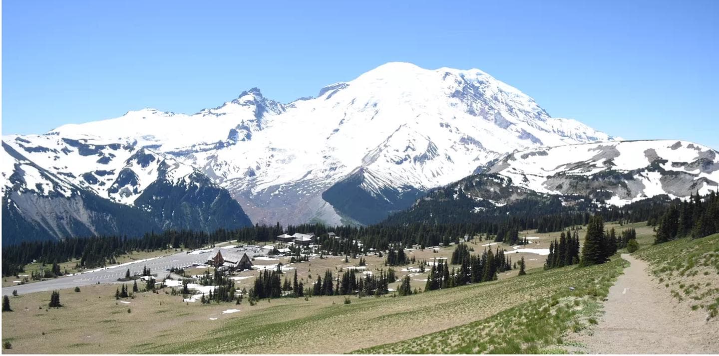
Overview White River Campground is available on a first come first serve basis. The campround sits at 4,440 ft in elevation, 1200 ft higher than any other campground with amenities in Mount Rainier National Park. For this reason, winter lingers long and comes early. White River often opens at the end of June or early July and stays open in late September. The campground has are 88 campsites that cost $20 a night. There is a 27 ft RV limit and an 18ft trailer limit. Use the Recreation.gov Mobile App to pay the nightly camping fee when you arrive at the campground. Prior to arriving at the campground download the Recreation.gov App to your mobile device and create a Recreation.gov account. Recreation There are plenty of hiking opporunities as well as rich ecological sytems that will interest amateur botanists and mycologists. Facilities There are plenty of hiking opporunities as well as rich ecological sytems that will interest amateur botanists and mycologists. Natural Features This high elevation campground is located near the White River and in a lovely forest. Trails crisscross the campground, including the Wonderland, Burrough Mountain and Glacier Basin Camp Trails. Nearby Attractions Trails: Glacier Basin, Burroughs Mountain, the Wonderland and the River Trail. The White River Ten miles to Sunrise Five miles from Highway 410 Four miles to the a Ranger Station Charges & Cancellations Currently White River is a first-come, first-served campgrounds so there are no cancellations.
View details →
WA · Campground
Overview Ohanapecosh Campground, on the southeast side of Mount Rainier National Park, is surrounded by old growth forest and crossed by an exceptionally beautiful snow-fed river. Close to Ohanapecosh are popular hikes to Silver Falls and the Grove of the Patriarchs. The main attraction at Mount Rainier National Park is the mountain itself, a glacier-clad volcano of immense proportions. At 14,411 ft., it dominates the skyline for hundreds of miles. Visitors travel through majestic old-growth forests, past tumbling waterfalls and historic buildings to reach sub-alpine meadows, where world-famous wildflower displays are seen in July and August. Popular activities in the park include sight-seeing, hiking, climbing and camping. Ohanapecosh campground has an elevation of 1,914 feet. Weather is dry, cool and sunny in the summer with daytime temperatures in the 60 to 80-degree range. Even though the eastern side of the park can be sunnier than other areas, weather can be variable and visitors should come prepared. Recreation The most popular campground in the park, Ohanapecosh is convenient to both the Paradise and Sunrise areas. Numerous hiking trails originate both in and nearby the facility, including the Grove of the Patriarchs trail, which leads hikers through stands of old growth forest, and several trails that lead to Silver Falls waterfall. For visitors who would like to learn more about natural and cultural history, the Ohanapecosh Visitor Center is close by as well. Facilities The most popular campground in the park, Ohanapecosh is convenient to both the Paradise and Sunrise areas. Numerous hiking trails originate both in and nearby the facility, including the Grove of the Patriarchs trail, which leads hikers through stands of old growth forest, and several trails that lead to Silver Falls waterfall. For visitors who would like to learn more about natural and cultural history, the Ohanapecosh Visitor Center is close by as well. Natural Features Ohanapecosh is thought to be a Taidnapam Indian word for "standing on the edge" of the Ohanapecosh River. The river itself is lined with mossy boulders and drains cold, clear water down from higher elevations. Its banks are lined with thick, old growth Douglas fir trees and other evergreens. There is no view of Mt. Rainier directly from the campground, though the mountain dominates the landscape in nearby areas of the park. Charges & Cancellations If a camper does not check-in at the Ohanapecosh Visitor Center at the campground window by 12:00pm check-out time the day after the scheduled arrival date, their reservation will be cancelled, the camper will incur a $10.00 service fee, and forfeit the first night's camping fee.
View details →
WA · Campground
Overview This facility is the group site at Ohanapecosh Campground. Ohanapecosh, on the southeast side of Mount Rainier National Park, is surrounded by old growth forest and crossed by an exceptionally beautiful snow-fed river. Close to Ohanapecosh are popular hikes to Silver Falls and the Grove of the Patriarchs. The main attraction at Mount Rainier National Park is the mountain itself, a glacier-clad volcano of immense proportions. At 14,411 ft., it dominates the skyline for hundreds of miles. Visitors travel through majestic old-growth forests, past tumbling waterfalls and historic buildings to reach sub-alpine meadows, where world-famous wildflower displays are seen in July and August. Popular activities in the park include sight-seeing, hiking, climbing and camping. Ohanapecosh campground has an elevation of 1,914 feet. Weather is dry, cool and sunny in the summer with daytime temperatures in the 60 to 80-degree range. Even though the eastern side of the park can be sunnier than other areas, weather can be variable and visitors should come prepared. Recreation The most popular campground in the park, Ohanapecosh is convenient to both the Paradise and Sunrise areas. Numerous hiking trails originate both in and nearby the facility, including the Grove of the Patriarchs trail, which leads hikers through stands of old growth forest, and several trails that lead to Silver Falls waterfall. For visitors who would like to learn more about natural and cultural history, the Ohanapecosh Visitor Center is close by. Facilities The most popular campground in the park, Ohanapecosh is convenient to both the Paradise and Sunrise areas. Numerous hiking trails originate both in and nearby the facility, including the Grove of the Patriarchs trail, which leads hikers through stands of old growth forest, and several trails that lead to Silver Falls waterfall. For visitors who would like to learn more about natural and cultural history, the Ohanapecosh Visitor Center is close by. Natural Features Ohanapecosh is thought to be a Taidnapam Indian word for "standing on the edge" of the Ohanapecosh River. The river itself is lined with mossy boulders and drains cold, clear water from higher elevations. Its banks are lined with thick, old growth Douglas fir trees and other evergreens. There is no direct view of Mt. Rainier from the campground, but the mountain dominates the landscape in nearby areas of the park.
View details →
WA · Campground
Overview Situated in the vicinity of majestic Mount Rainier, Big Creek is a family campground nestled among Douglas firs, hemlock, alders and maples. The lush vegetation offers plenty of privacy between sites. The sites at Big Creek form a loop, with only a handful of sites sitting along the banks of Big Creek. Open from mid-May through late September, Big Creek provides an alternative to the campgrounds at Mount Rainier National Park, which can get very crowded during the summer. Recreation Anglers can try their luck at catching brook trout in Big Creek or for those looking to explore the area, the Osborne Mountain Trail starts at the campground. The route is steep, but the scenery is amazing, and the trail can be traversed by foot, horse, mountain bike or dirt bike. Facilities Anglers can try their luck at catching brook trout in Big Creek or for those looking to explore the area, the Osborne Mountain Trail starts at the campground. The route is steep, but the scenery is amazing, and the trail can be traversed by foot, horse, mountain bike or dirt bike. Natural Features Located in southwest Washington State, the Gifford Pinchot National Forest encompasses over 1.3 million acres and includes the 110,000-acre Mount St. Helens National Volcanic Monument established by Congress in 1982. Big Creek is located in the Cowlitz Valley Ranger District, the northernmost portion of the Gifford Pinchot National Forest. This Ranger District manages four Wilderness Areas including the Goat Rocks Wilderness, Glacier View Wilderness, Tatoosh Wilderness and William O' Douglass Wilderness. The Cowlitz Valley Ranger District is roughly located among three volcanic peaks: Mt. Rainier to the north, Mt. Adams to the east, and Mt. St. Helens to the west, providing visitors with a unique geological landscape. contact_info This location has limited staffing. Please call (360) 686-3008 for general information. Nearby Attractions Big Creek is 6 miles from the Nisqually entrance of Mount Rainier National Park. The popular Henry M. Jackson Memorial Visitor Center at Paradise is 21 miles away, and the nearby town of Ashford offers restaurants, along with a few art galleries and shops. Charges & Cancellations Cancellations Individual Campsites: Cancellations up to 2 days before a reservation start date incur a $10.00 cancellation fee. A visitor who cancels a reservation the day before or on the day of arrival will pay a $10.00 service fee AND forfeit the first night's use fee including tax and applicable add-on for a campsite. Cancellations for a one-night reservation will forfeit the entire amount paid and will not be subject to an additional service fee. No-Shows A no-show visitor is one who does not arrive at a campground and does not cancel the reservation by check-out time on the day after the scheduled arrival date. Staff will hold a campsite until check-out time on the day following the arrival date. No-shows are assessed $20.00 service fee and forfeit the first night's rate, taxes and applicable add-on for a campsite. Refunds Visitors may submit a refund request through their Recreation.gov profile within 7 days of the end date of their reservation. Refunds will not be issued after the 7 days has ended. Refunds for debit or credit card payments will be issued as a credit to the original bank or credit card used to pay. For check or cash purchases, Recreation.gov will mail a Treasury check for refunds of cash, check, or money order payments to the address associated with the reservation. Treasury check refunds may take up to 6-8 weeks to arrive. In the event of an emergency closure, the Recreation.gov team or facility manager will refund all fees and will attempt to notify you using the contact information within the Recreation.gov visitor profile.
View details →
WA · Campground
Overview Silver Springs Campground is situated on the banks of the scenic White River in Mt. Baker-Snoqualmie National Forest, just outside Mt. Rainier National Park's North Arch entrance. Silver Springs offers visitors stunning scenery and access to a multitude of recreational activities. Recreation The White River sustains populations of salmon and trout, making it a great spot for fishing. A natural spring flows through the campground as well. Hiking and climbing top the list of recreational activities in the surrounding area. The 0.5-mile, accessible John Muir Nature Trail begins at nearby Dalles Campground. Visitors enjoy gazing up the "Big Tree," at an old-growth Douglas fir tree inside Dalles. This giant measures 9.5 feet in diameter and is over 700 years old. The tree stands at the beginning of the Dalles River View Trail, originating at the west end of the campground loop. Local Crystal Mountain Trail begins about five miles southwest of the campground. It climbs 1,600 feet in elevation through clear-cut areas and second-growth forest before breaking out to expansive views of the White River Valley and Mt. Rainier. The trail continues to climb along the ridge, showcasing wildflowers in early June and huckleberries in early August. Facilities The White River sustains populations of salmon and trout, making it a great spot for fishing. A natural spring flows through the campground as well. Hiking and climbing top the list of recreational activities in the surrounding area. The 0.5-mile, accessible John Muir Nature Trail begins at nearby Dalles Campground. Visitors enjoy gazing up the "Big Tree," at an old-growth Douglas fir tree inside Dalles. This giant measures 9.5 feet in diameter and is over 700 years old. The tree stands at the beginning of the Dalles River View Trail, originating at the west end of the campground loop. Local Crystal Mountain Trail begins about five miles southwest of the campground. It climbs 1,600 feet in elevation through clear-cut areas and second-growth forest before breaking out to expansive views of the White River Valley and Mt. Rainier. The trail continues to climb along the ridge, showcasing wildflowers in early June and huckleberries in early August. Natural Features The campground's widely-spaced sites are scattered in a beautiful section of old-growth forest, where many sit on the banks of the White River, which is sourced by flowing water from ice caves at the base of Emmons Glacier on Mt. Rainier. The Mt. Baker-Snoqualmie National Forest showcases rugged peaks, sparkling alpine lakes and old-growth forests. Several designated wilderness areas surround the forest. Mt. Rainier, the highest peak in Washington and the Cascades Range, dominates the landscape on clear days. The volcano rises to an elevation of 14,411 feet and is perpetually snow-capped, boasting a total of 36-square miles of snowfields and glaciers. Wildlife in the area ranges from mountain goats in the higher elevations to porcupines and pine martens in the forests. Migratory birds and native fish find ample habitat in the varied ecosystems. contact_info For facility specific information, please call (530) 932-0242. Nearby Attractions Mount Rainier National Park offers fantastic glimpses of glaciers, subalpine ecology and volcanic landscapes. Hiking trails and scenic drives crisscross the park. Visit or stay in one of the historic lookouts in the area. Lookouts are tangible symbols of Forest Service heritage, perched on high peaks with unobstructed views where they have been used throughout the years to detect fires in remote forest lands. Charges & Cancellations Once your reservation start date has begun, neither the Recreation.gov Contact Center nor the campground manager will be able to modify your reservation.
View details →
WA · Campground
Overview Situated at the confluence of three waterways near Mount Rainier, La Wis Wis is nestled under a canopy of towering Douglas firs and red cedars. The handful of sites that dot the riverbank enjoy the most sunshine. With an abundance of activities nearby, La Wis Wis is a popular destination for long-stay camping. Its proximity to Mount Rainier National Park makes it an excellent base for exploring all of the area's natural wonders. Recreation Hikers can easily access the Blue Hole Trail and Purcell Falls Trail from La Wis Wis. Anglers can fish for rainbow trout, cutthroat trout and whitefish at either Butter Creek or Skate Creek. Facilities Hikers can easily access the Blue Hole Trail and Purcell Falls Trail from La Wis Wis. Anglers can fish for rainbow trout, cutthroat trout and whitefish at either Butter Creek or Skate Creek. Natural Features Located in southwest Washington State, the Gifford Pinchot National Forest encompasses 1.3 million acres and includes the 110,000-acre Mount St. Helens National Volcanic Monument, established by Congress in 1982. La Wis Wis is located in the Tatoosh Wilderness area of the Cowlitz Valley Ranger District. The campground sits where the Ohanapecosh River, Cowlitz River and Purcell Creek meet. The campground features old-growth forest and opportunities to observe a variety of wildlife. Nearby Attractions La Wis Wis is located near the entrance to Mount Rainier National Park. The popular Henry M Jackson Memorial Visitor Center at Paradise within Mount Rainier National Park is 28 miles away. contact_info This location has limited staffing. Please call (360) 686-3008 for general information. Charges & Cancellations Cancellations Individual Campsites: Cancellations up to 2 days before a reservation start date incur a $10.00 cancellation fee. A visitor who cancels a reservation the day before or on the day of arrival will pay a $10.00 service fee AND forfeit the first night's use fee including tax and applicable add-on for a campsite. Cancellations for a one-night reservation will forfeit the entire amount paid and will not be subject to an additional service fee. Group Sites Group Facility (including Cabins and Lookouts): A visitor who cancels a group overnight facility reservation less than 14 days before the arrival date will pay a $10.00 service fee AND forfeit the first night's use fee. No-Shows A no-show visitor is one who does not arrive at a campground and does not cancel the reservation by check-out time on the day after the scheduled arrival date. Staff will hold a campsite until check-out time on the day following the arrival date. No-shows are assessed $20.00 service fee and forfeit the first night's rate, taxes and applicable add-on for a campsite. Refunds Visitors may submit a refund request through their Recreation.gov profile within 7 days of the end date of their reservation. Refunds will not be issued after the 7 days has ended. Refunds for debit or credit card payments will be issued as a credit to the original bank or credit card used to pay. For check or cash purchases, Recreation.gov will mail a Treasury check for refunds of cash, check, or money order payments to the address associated with the reservation. Treasury check refunds may take up to 6-8 weeks to arrive. In the event of an emergency closure, the Recreation.gov team or facility manager will refund all fees and will attempt to notify you using the contact information within the Recreation.gov visitor profile.
View details →
WA · Campground
Overview Situated on the banks of the White River in Mt. Baker-Snoqualmie National Forest, Dalles Campground offers visitors stunning scenery and access to a multitude of recreational activities within the Cascade region. Scattered beneath a towering canopy of diverse forest, the sites in this campground are widely-spaced and many are at the water's edge. Recreation Hiking and fishing top the list of recreational activities in the area. For visitors wanting a glimpse at the wonders of the area, hikes for all levels and abilities abound. For a shorter hike, the John Muir Nature Trail is a half-mile, barrier-free nature trail that begins at the historic picnic shelter near the entrance of the campground. Marking the beginning of the Dalles River View trail at the west end of the campground loop is the "Big Tree," a 700 year-old Douglas fir that measures 9.5 feet in diameter. Anglers will enjoy fly fishing on the White River and its tributaries, as it sustains several species of salmon and trout. Facilities Hiking and fishing top the list of recreational activities in the area. For visitors wanting a glimpse at the wonders of the area, hikes for all levels and abilities abound. For a shorter hike, the John Muir Nature Trail is a half-mile, barrier-free nature trail that begins at the historic picnic shelter near the entrance of the campground. Marking the beginning of the Dalles River View trail at the west end of the campground loop is the "Big Tree," a 700 year-old Douglas fir that measures 9.5 feet in diameter. Anglers will enjoy fly fishing on the White River and its tributaries, as it sustains several species of salmon and trout. Natural Features Hemmed in by several designated wilderness areas, the Mt. Baker-Snoqualmie National Forest showcases rugged peaks, sparkling alpine lakes and old-growth forests, providing visitors with a variety of scenic landscapes. Mt. Rainer, the highest mountain in Washington and the Cascades range, dominates the landscape on a clear day. Rising to an elevation of 14,411 feet, the stratovolcano is perpetually snow-capped, boasting a total of 36-square miles of snowfields and glaciers. Two volcanic craters top the summit of this magnificent peak. Flowing water from ice caves at the base of Emmons Glacier in Mt. Rainer National Park is the source of the White River, which enters the forest and joins up with Huckleberry Creek just below the Dalles Campground. Wildlife in the area include mountain goats, coyotes, pine marten and a variety of migratory birds and native fish. contact_info For facility specific information, please call (530) 932-0242. Nearby Attractions Visitors enjoy the North Cascades and Mt. Rainer National Parks, where interpretive programs and exhibits offer education about the diverse landscape and history of the area. Charges & Cancellations Once your reservation start date has begun, neither the Recreation.gov Contact Center nor the campground manager will be able to modify your reservation.
View details →
Overview Lodgepole Campground is located in the Okanogan-Wenatchee National Forest in the Northern Cascade Range of Washington. With the scenic waters of the American River running alongside the site, and access to pristine wilderness, scenic highways and a multitude of recreational activities nearby, the campground offers an ideal setting for outdoor enthusiasts. Please note, this campground IS NOT within Sequoia National Park. Recreation Lodgepole Campground offers outdoor enthusiasts the opportunity to hike, fish, ski, raft and enjoy a multitude of outdoor recreational activities throughout the year. Beautiful rivers and streams, high elevation lakes, reservoirs, and small ponds provide an endless number of fishing opportunities for the experienced and beginning angler. The American River, adjacent to the campground, supports a variety of trout including rainbow, brook, and cutthroat. The river also offers a scenic backdrop for swimmers braving its cold, refreshing waters. Whitewater enthusiasts enjoy rafting on the American or one of the many other rivers in the area. Facilities Lodgepole Campground offers outdoor enthusiasts the opportunity to hike, fish, ski, raft and enjoy a multitude of outdoor recreational activities throughout the year. Beautiful rivers and streams, high elevation lakes, reservoirs, and small ponds provide an endless number of fishing opportunities for the experienced and beginning angler. The American River, adjacent to the campground, supports a variety of trout including rainbow, brook, and cutthroat. The river also offers a scenic backdrop for swimmers braving its cold, refreshing waters. Whitewater enthusiasts enjoy rafting on the American or one of the many other rivers in the area. Natural Features The stunning beauty of the Okanogan-Wenatchee National Forest attracts visitors from throughout the country, with its high, glaciated alpine peaks towering along the Cascade Crest. Lush valleys of old-growth forest define its western boundary and at its eastern edge, rugged shrub-steppe country comprises a more arid region. Elevations range from below 1,000 feet to over 9,000 feet. Precipitation varies greatly thoughout the area, ranging from approximately 140 inches along the Cascade Crest to only 10 inches along the eastern edge. Visitors can expect many days of warm, sunny weather in the summer and clear skies and plenty of snow in the winter. Nearby Goat Rocks Wilderness is an exciting adventure for those wanting to traverse higher elevations. Peaks within the area are remnants of an extinct volcano, taking the name "Goat Rocks," in honor of the numerous mountain goats traversing this isolated region. Gilbert Peak is the highest summit in this area at an elevation of 8,184 feet. contact_info This location has limited staffing. Please call (661) 702-1420 for general information. Nearby Attractions Crow Lake, Swamp Lake, Cougar Valley and Union Creek Trails all have trailheads near Lodgepole Campground. Hikers may also want to traverse at least a portion of the spectacular Pacific Crest Trail (PCT), one of the world's premier National Scenic Trails. Boulder Cave National Recreation Trail is one of the most popular places in the Naches District. Visitors can walk the accessible trail along the river or explore Boulder Cave. Interpretive signs along the trail explain the geology, plants, animals and fire history of the area. Nearby Mount Rainier National Park offers fantastic glimpses of glaciers, subalpine ecology and volcanic landscapes. Charges & Cancellations Cancellations Individual Campsites: Cancellations up to 2 days before a reservation start date incur a $10.00 cancellation fee. A visitor who cancels a reservation the day before or on the day of arrival will pay a $10.00 service fee AND forfeit the first night's use fee including tax and applicable add-on for a campsite. Cancellations for a one-night reservation will forfeit the entire amount paid and will not be subject to an additional service fee. No-Shows A no-show visitor is one who does not arrive at a campground and does not cancel the reservation by check-out time on the day after the scheduled arrival date. Staff will hold a campsite until check-out time on the day following the arrival date. No-shows are assessed $20.00 service fee and forfeit the first night's rate, taxes and applicable add-on for a campsite. Refunds Visitors may submit a refund request through their Recreation.gov profile within 7 days of the end date of their reservation. Refunds will not be issued after the 7 days has ended. Refunds for debit or credit card payments will be issued as a credit to the original bank or credit card used to pay. For check or cash purchases, Recreation.gov will mail a Treasury check for refunds of cash, check, or money order payments to the address associated with the reservation. Treasury check refunds may take up to 6-8 weeks to arrive. In the event of an emergency closure, the Recreation.gov team or facility manager will refund all fees and will attempt to notify you using the contact information within the Recreation.gov visitor profile.
View details →
WA · Campground
Overview Pleasant Valley Campground is located in the Okanogan-Wenatchee National Forest in the Northern Cascade Range of Washington. With the scenic waters of the American River running alongside the site, and access to pristine wilderness, scenic highways, and a multitude of recreational activities nearby, this campsite offers an ideal setting for outdoor enthusiasts. Recreation Pleasant Valley Campground offers outdoor enthusiasts the opportunity to hike, fish, ski, raft and enjoy a multitude of other outdoor recreational activities throughout the year. Beautiful rivers and streams, high elevation lakes, reservoirs, and small ponds provide an endless number of fishing opportunities for the experienced and beginning angler. The American River, adjacent to the campground, supports a variety of trout including rainbow, brook, and cutthroat. The river also offers a scenic backdrop for swimmers braving its cold, refreshing waters. Whitewater enthusiasts may enjoy a rafting trip on the American, or on one of the many other scenic rivers in the area. Facilities Pleasant Valley Campground offers outdoor enthusiasts the opportunity to hike, fish, ski, raft and enjoy a multitude of other outdoor recreational activities throughout the year. Beautiful rivers and streams, high elevation lakes, reservoirs, and small ponds provide an endless number of fishing opportunities for the experienced and beginning angler. The American River, adjacent to the campground, supports a variety of trout including rainbow, brook, and cutthroat. The river also offers a scenic backdrop for swimmers braving its cold, refreshing waters. Whitewater enthusiasts may enjoy a rafting trip on the American, or on one of the many other scenic rivers in the area. Natural Features The unique beauty of the Okanogan-Wenatchee National Forest attracts visitors from throughout the country. High, glaciated alpine peaks tower along the Cascade Crest. Lush valleys of old growth forest define its western boundary, and at its eastern edge, rugged shrub-steppe country comprises a more arid region. Elevations range from below 1,000 feet to over 9,000 feet. Precipitation varies greatly thoughout the area, ranging from approximately 140 inches along the Cascade Crest to only 10 inches along the eastern edge. Visitors to the area can expect many days of warm, sunny weather in the summer, and clear skies and plenty of snow in winter. Nearby Goat Rocks Wilderness is an exciting adventure for those wanting to traverse higher elevations. Peaks within the area are remnants of an extinct volcano, taking the name "Goat Rocks," in honor of the numerous mountain goats traversing this isolated region. Gilbert Peak is the highest summit in this area at an elevation of 8,184 feet. contact_info This location has limited staffing. Please call (661) 702-1420 for general information. Nearby Attractions Crow Lake, Swamp Lake, Cougar Valley and Union Creek Trails all have trailheads near Pleasant Valley Campground. Hikers may also want to traverse at least a portion of the spectacular Pacific Crest Trail (PCT), one of the world's premier National Scenic Trails. Boulder Cave National Recreation Trail is one of the most popular places in the Naches District. Visitors can walk the accessible trail along the river or explore Boulder Cave. Interpretive signs along the trail explain the geology, plants, animals, and fire history of the area. Nearby Mount Rainier National Park offers fantastic glimpses of glaciers, subalpine ecology and volcanic landscapes. Charges & Cancellations Cancellations Individual Campsites: Cancellations up to 2 days before a reservation start date incur a $10.00 cancellation fee. A visitor who cancels a reservation the day before or on the day of arrival will pay a $10.00 service fee AND forfeit the first night's use fee including tax and applicable add-on for a campsite. Cancellations for a one-night reservation will forfeit the entire amount paid and will not be subject to an additional service fee. No-Shows A no-show visitor is one who does not arrive at a campground and does not cancel the reservation by check-out time on the day after the scheduled arrival date. Staff will hold a campsite until check-out time on the day following the arrival date. No-shows are assessed $20.00 service fee and forfeit the first night's rate, taxes and applicable add-on for a campsite. Refunds Visitors may submit a refund request through their Recreation.gov profile within 7 days of the end date of their reservation. Refunds will not be issued after the 7 days has ended. Refunds for debit or credit card payments will be issued as a credit to the original bank or credit card used to pay. For check or cash purchases, Recreation.gov will mail a Treasury check for refunds of cash, check, or money order payments to the address associated with the reservation. Treasury check refunds may take up to 6-8 weeks to arrive. In the event of an emergency closure, the Recreation.gov team or facility manager will refund all fees and will attempt to notify you using the contact information within the Recreation.gov visitor profile.
View details →
WA · Campground
Overview Bumping Lake Campground sits just off the forested shore of Bumping Lake in the Cascade Mountains east of Mount Rainier National Park, about 45 miles northwest of Naches, Washington. Fantastic peaks, high-country lakes and old-growth forests provide visitors with unique and surprising landscapes, making the campground an ideal setting for both individual and family camping excursions. Recreation In addition to being a prime location for hiking, boating, fishing, hunting, horseback riding and mountain biking in summer and early fall, visitors can take advantage of skiing, snowshoeing and snowmobiling in the winter months. Bumping Lake is a popular destination for boating, water skiing, fishing and swimming. A boat ramp is located in the lower section of the campground. The American Ridge Trail is a popular among hikers and equestrians, meandering through more than 26 miles of towering forests, mountain meadows and past high elevation lakes from the Bumping River to the Pacific Crest Trail. Facilities In addition to being a prime location for hiking, boating, fishing, hunting, horseback riding and mountain biking in summer and early fall, visitors can take advantage of skiing, snowshoeing and snowmobiling in the winter months. Bumping Lake is a popular destination for boating, water skiing, fishing and swimming. A boat ramp is located in the lower section of the campground. The American Ridge Trail is a popular among hikers and equestrians, meandering through more than 26 miles of towering forests, mountain meadows and past high elevation lakes from the Bumping River to the Pacific Crest Trail. Natural Features Bumping Lake was created naturally by glaciers and is fed by snowmelt. It is surrounded by rugged mountain terrain, wetlands and old-growth conifer forests. The area supports wildlife such as deer, porcupine, native fish and migratory birds. Endangered and threatened species, including the Northern Bald Eagle, the Northern Spotted Owl, gray wolves and grizzly bears also find havens in nearby ecosystems. contact_info This location has limited staffing. Please call (661) 702-1420 for general information. Nearby Attractions Visitors enjoy making a day trip to nearby Mount Rainer National Park, which offers sublime views of glaciers, subalpine ecology and volcanic landscapes. Hikers may want to traverse a portion of the spectacular Pacific Crest Trail (PCT), one of the world's premier National Scenic Trails. This trail showcases some of North America's most fantastic scenery as it winds its way from Mexico to Canada through California, Oregon and Washington. Charges & Cancellations Cancellations Individual Campsites: Cancellations up to 2 days before a reservation start date incur a $10.00 cancellation fee. A visitor who cancels a reservation the day before or on the day of arrival will pay a $10.00 service fee AND forfeit the first night's use fee including tax and applicable add-on for a campsite. Cancellations for a one-night reservation will forfeit the entire amount paid and will not be subject to an additional service fee. No-Shows A no-show visitor is one who does not arrive at a campground and does not cancel the reservation by check-out time on the day after the scheduled arrival date. Staff will hold a campsite until check-out time on the day following the arrival date. No-shows are assessed $20.00 service fee and forfeit the first night's rate, taxes and applicable add-on for a campsite. Refunds Visitors may submit a refund request through their Recreation.gov profile within 7 days of the end date of their reservation. Refunds will not be issued after the 7 days has ended. Refunds for debit or credit card payments will be issued as a credit to the original bank or credit card used to pay. For check or cash purchases, Recreation.gov will mail a Treasury check for refunds of cash, check, or money order payments to the address associated with the reservation. Treasury check refunds may take up to 6-8 weeks to arrive. In the event of an emergency closure, the Recreation.gov team or facility manager will refund all fees and will attempt to notify you using the contact information within the Recreation.gov visitor profile.
View details →
Overview Salmon Cove Group Campground is located on the pebble-strewn bank of the American River in the Okanogan-Wenatchee National Forest, providing a nice setting for groups and larger gatherings. Visitors enjoy fishing, rafting and hiking in the surrounding area. Recreation Salmon Cove Group Campground offers outdoor enthusiasts the opportunity to hike, fish, ski, raft and enjoy a multitude of recreational activities throughout the year. The American River flows next to the campground, offering a scenic backdrop for swimmers, rafters and kayakers braving its cold, refreshing waters. Anglers drop lines for rainbow and brown trout in many deep pools lining the shore. Nearby American Ridge Trail is open to hiking, backpacking and horseback riding. The trail extends 26 miles from Bumping River to the notable Pacific Crest Trail, meandering through towering forests, stretches of meadows and past alpine lakes, offering scenic ridge line views along the way. Facilities Salmon Cove Group Campground offers outdoor enthusiasts the opportunity to hike, fish, ski, raft and enjoy a multitude of recreational activities throughout the year. The American River flows next to the campground, offering a scenic backdrop for swimmers, rafters and kayakers braving its cold, refreshing waters. Anglers drop lines for rainbow and brown trout in many deep pools lining the shore. Nearby American Ridge Trail is open to hiking, backpacking and horseback riding. The trail extends 26 miles from Bumping River to the notable Pacific Crest Trail, meandering through towering forests, stretches of meadows and past alpine lakes, offering scenic ridge line views along the way. Natural Features The Okanogan-Wenatchee is comprised of high, glaciated alpine peaks towering along the Cascade Crest, where lush valleys of old-growth forest define its western boundary. At its eastern edge, rugged shrub-steppe country comprises a more arid region. Elevations range from below 1,000 feet to over 9,000 feet. Precipitation varies greatly throughout the area, ranging from approximately 140 inches along the Cascade Crest to only 10 inches along the eastern edge. Visitors can expect many days of warm, sunny weather in the summer, and plenty of snow in the winter. The area supports wildlife such as deer, porcupine, native fish and migratory birds. Nearby Attractions Boulder Cave National Recreation Trail is one of the most popular places in the Naches District. Visitors can walk the accessible trail along the river or explore Boulder Cave. Interpretive signs along the trail explain the geology, plants, animals and fire history of the area. Visitors may want to take some time to visit nearby Mount Rainier National Park. This beautiful park offers fantastic glimpses of glaciers, subalpine ecology and volcanic landscapes. Visitors also enjoy traversing the Chinook Scenic Byway, considered one of Washington's premier driving excursions. Spectacular views of Mount Rainier, old-growth forests, alpine peaks, jagged ridges and river canyons dominate this 92-mile journey.
View details →
WA · Campground
Overview Hells Crossing Campground is located along the American River in the Okanogan-Wenatchee National Forest in Washington's Cascade Range. Warm summer days and easy access to an abundance of recreational activities make the campground a perfect setting for individual and group camping excursions. Recreation Hells Crossing Campground offers outdoor enthusiasts the opportunity to hike, fish, ski, raft and enjoy a multitude of recreational activities throughout the year. The American River, which can be accessed from within the campground, offers a scenic backdrop for swimmers braving its cold, refreshing waters. Whitewater enthusiasts may enjoy a rafting trip on the American or on one of many scenic rivers in the area. Facilities Hells Crossing Campground offers outdoor enthusiasts the opportunity to hike, fish, ski, raft and enjoy a multitude of recreational activities throughout the year. The American River, which can be accessed from within the campground, offers a scenic backdrop for swimmers braving its cold, refreshing waters. Whitewater enthusiasts may enjoy a rafting trip on the American or on one of many scenic rivers in the area. Natural Features The Okanogan-Wenatchee is a unique National Forest, where high, glaciated alpine peaks tower along the Cascade Crest. Lush valleys of old-growth forest define its western boundary, and at its eastern edge, rugged shrub-steppe country comprises a more arid region. Elevations range from below 1,000 feet to over 9,000 feet. Precipitation varies greatly thoughout the area, ranging from approximately 140 inches along the Cascade Crest to only 10 inches along the eastern edge. Visitors to the area can expect many days of warm, sunny weather in the summer and plenty of snow in the winter. Nearby Attractions Boulder Cave National Recreation Trail is one of the most popular places in the Naches District. Visitors can walk the accessible trail along the river or explore Boulder Cave. Interpretive signs along the trail explain the geology, plants, animals and fire history of the area. Hikers may want to traverse a portion of the spectacular Pacific Crest Trail (PCT), one of the world's premier National Scenic Trails. This trail showcases some of North America's most fantastic scenery as it winds its way from Mexico to Canada through California, Oregon and Washington. contact_info This location has limited staffing. Please call (661) 702-1420 for general information. Charges & Cancellations Cancellations Individual Campsites: Cancellations up to 2 days before a reservation start date incur a $10.00 cancellation fee. A visitor who cancels a reservation the day before or on the day of arrival will pay a $10.00 service fee AND forfeit the first night's use fee including tax and applicable add-on for a campsite. Cancellations for a one-night reservation will forfeit the entire amount paid and will not be subject to an additional service fee. No-Shows A no-show visitor is one who does not arrive at a campground and does not cancel the reservation by check-out time on the day after the scheduled arrival date. Staff will hold a campsite until check-out time on the day following the arrival date. No-shows are assessed $20.00 service fee and forfeit the first night's rate, taxes and applicable add-on for a campsite. Refunds Visitors may submit a refund request through their Recreation.gov profile within 7 days of the end date of their reservation. Refunds will not be issued after the 7 days has ended. Refunds for debit or credit card payments will be issued as a credit to the original bank or credit card used to pay. For check or cash purchases, Recreation.gov will mail a Treasury check for refunds of cash, check, or money order payments to the address associated with the reservation. Treasury check refunds may take up to 6-8 weeks to arrive. In the event of an emergency closure, the Recreation.gov team or facility manager will refund all fees and will attempt to notify you using the contact information within the Recreation.gov visitor profile.
View details →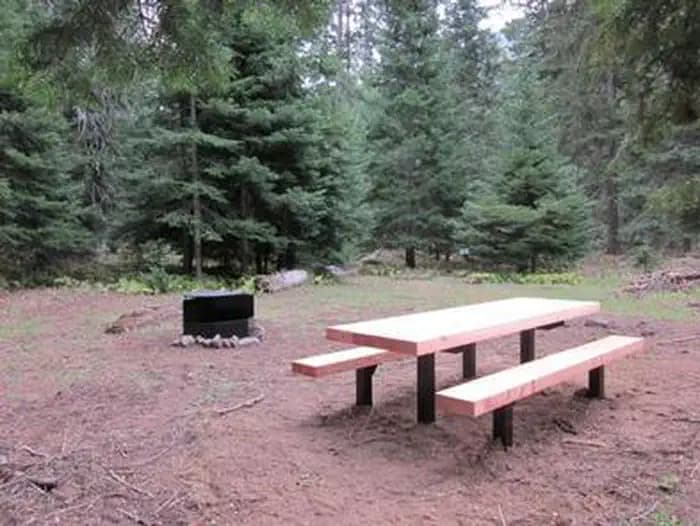
WA · Campground
Overview Cougar Flat Campground is nestled into a mountain forest northwest of Naches, Washington. The campground offers an ideal setting for families and outdoor enthusiasts looking for a secluded camping experience in the beautiful Okanogan National Forest. Recreation In addition to being a prime location for hiking, fishing, hunting, horseback riding and mountain biking in summer and early fall, Cougar Flat offers excellent skiing, snowshoeing and snowmobiling in the winter months. Nearby Bumping Lake offers visitors opportunities to boat, fish, swim or simply relax on its sandy beach. The campground is a great base camp for day-hikers and overnight backpackers. Several access trails from the area give hikers the chance to create their own excursions. The American Ridge Trail is a popular among hikers and equestrians, meandering through more than 26 miles of towering forests, mountain meadows and high elevation lakes from the Bumping River to Pacific Crest Trail. Nature lovers may also want to explore the nearby Goose Prairie Trail. Facilities In addition to being a prime location for hiking, fishing, hunting, horseback riding and mountain biking in summer and early fall, Cougar Flat offers excellent skiing, snowshoeing and snowmobiling in the winter months. Nearby Bumping Lake offers visitors opportunities to boat, fish, swim or simply relax on its sandy beach. The campground is a great base camp for day-hikers and overnight backpackers. Several access trails from the area give hikers the chance to create their own excursions. The American Ridge Trail is a popular among hikers and equestrians, meandering through more than 26 miles of towering forests, mountain meadows and high elevation lakes from the Bumping River to Pacific Crest Trail. Nature lovers may also want to explore the nearby Goose Prairie Trail. Natural Features Encompassing more than 4 million acres and stretching north to south from the Canadian border to the Goat Rocks Wilderness, the Okanogan National Forest offers countless recreation opportunities. Visitors are afforded stunning scenic views, with high, glaciated alpine peaks, valleys of old growth forest and rugged shrub-steppe country making up the diverse landscape. Elevations range from below 1,000 feet to more than 9,000 feet. The surrounding undeveloped wilderness, clean streams and diverse forests support an abundance of wildlife, including deer, porcupine, native fish and migratory birds. Endangered and threatened species, including the Northern Bald Eagle, the Northern Spotted Owl, gray wolves and grizzly bears, also find havens in nearby ecosystems. contact_info This location has limited staffing. Please call (661) 702-1420 for general information. Nearby Attractions In the fall thousands of visitors come to experience white water rafting on both the Tieton and American Rivers. Visitors enjoy the Mt. Rainer National Park, where interpretive programs and exhibits offer education about the diverse landscape and history of the area. The Pacific Crest Trail (PCT), one of the world's premier National Scenic Trails, showcases some of North America's most fantastic scenery, winding its way its way from Mexico to Canada through California, Oregon and Washington, and is accessible near the campground. Charges & Cancellations Cancellations Individual Campsites: Cancellations up to 2 days before a reservation start date incur a $10.00 cancellation fee. A visitor who cancels a reservation the day before or on the day of arrival will pay a $10.00 service fee AND forfeit the first night's use fee including tax and applicable add-on for a campsite. Cancellations for a one-night reservation will forfeit the entire amount paid and will not be subject to an additional service fee. No-Shows A no-show visitor is one who does not arrive at a campground and does not cancel the reservation by check-out time on the day after the scheduled arrival date. Staff will hold a campsite until check-out time on the day following the arrival date. No-shows are assessed $20.00 service fee and forfeit the first night's rate, taxes and applicable add-on for a campsite. Refunds Visitors may submit a refund request through their Recreation.gov profile within 7 days of the end date of their reservation. Refunds will not be issued after the 7 days has ended. Refunds for debit or credit card payments will be issued as a credit to the original bank or credit card used to pay. For check or cash purchases, Recreation.gov will mail a Treasury check for refunds of cash, check, or money order payments to the address associated with the reservation. Treasury check refunds may take up to 6-8 weeks to arrive. In the event of an emergency closure, the Recreation.gov team or facility manager will refund all fees and will attempt to notify you using the contact information within the Recreation.gov visitor profile.
View details →
WA · Campground
Overview Soda Springs Campground is set on the forested banks of the Bumping River in the Okanogan-Wenatchee National Forest. The area offers a delightful setting for visitors seeking recreation and relaxation. Recreation Soda Springs Campground offers outdoor enthusiasts the opportunity to hike, fish, ski, raft and enjoy a multitude of outdoor recreational activities throughout the year. The Bumping River, adjacent to the campground, offers a scenic backdrop for swimmers braving its cold, refreshing waters. Anglers may also want to cast a line into the deep pools lining the shore. Populations of rainbow, brook and steelhead trout prevail in this waterway. The nearby American Ridge Trail offers hikers, overnight backpackers and horseback riders fantastic opportunities to absorb some of the area's stunning beauty. Extending from Bumping River to the notable Pacific Crest Trail, the American Ridge Trail offers more than 26 miles of towering forests, stretches of meadows, alpine lakes and fantastic ridge line views. Trailheads for Goat Creek Trail, Nile Ridge Trail and the Richmond Mine Trail are also nearby. Facilities Soda Springs Campground offers outdoor enthusiasts the opportunity to hike, fish, ski, raft and enjoy a multitude of outdoor recreational activities throughout the year. The Bumping River, adjacent to the campground, offers a scenic backdrop for swimmers braving its cold, refreshing waters. Anglers may also want to cast a line into the deep pools lining the shore. Populations of rainbow, brook and steelhead trout prevail in this waterway. The nearby American Ridge Trail offers hikers, overnight backpackers and horseback riders fantastic opportunities to absorb some of the area's stunning beauty. Extending from Bumping River to the notable Pacific Crest Trail, the American Ridge Trail offers more than 26 miles of towering forests, stretches of meadows, alpine lakes and fantastic ridge line views. Trailheads for Goat Creek Trail, Nile Ridge Trail and the Richmond Mine Trail are also nearby. Natural Features Okanogan-Wenatchee National Forest offers stunning scenic views, with high, glaciated alpine peaks, valleys of old growth forest and rugged shrub-steppe country making up the diverse landscape. Elevations range from below 1,000 feet to more than 9,000 feet. Precipitation varies greatly throughout the area, ranging from approximately 140 inches along the Cascade Crest to only 10 inches along the eastern edge. Visitors to the area can expect many days of warm, sunny weather in the summer, and winters with clear skies and plenty of snow. The surrounding undeveloped wilderness, clean streams and diverse forests support an abundance of wildlife, including deer, porcupine, native fish and migratory birds. Endangered and threatened species, including the Northern Bald Eagle, the Northern Spotted Owl, gray wolves and grizzly bears, also find havens in nearby ecosystems. Nearby Attractions Boulder Cave National Recreation Trail is one of the most popular places in the Naches District. Visitors can walk the accessible trail along the river or explore Boulder Cave. Interpretive signs along the trail explain the geology, plants, animals and fire history of the area. Visitors may want to take some time to visit nearby Mount Rainer National Park. Considered a wonderland, the park offers a fantastic glimpse into glaciers, sub-alpine ecology and volcanic landscapes typical in the region. Nearby Goat Rocks Wilderness is a stunning adventure for those wanting to traverse higher elevations. Peaks within the area are remnants of an extinct volcano, taking the name "Goat Rocks," in honor of the numerous mountain goats traversing this isolated region. Gilbert Peak is the highest summit in this area, at an elevation of 8,184 feet. contact_info This location has limited staffing. Please call (661) 702-1420 for general information. Charges & Cancellations Cancellations Individual Campsites: Cancellations up to 2 days before a reservation start date incur a $10.00 cancellation fee. A visitor who cancels a reservation the day before or on the day of arrival will pay a $10.00 service fee AND forfeit the first night's use fee including tax and applicable add-on for a campsite. Cancellations for a one-night reservation will forfeit the entire amount paid and will not be subject to an additional service fee. No-Shows A no-show visitor is one who does not arrive at a campground and does not cancel the reservation by check-out time on the day after the scheduled arrival date. Staff will hold a campsite until check-out time on the day following the arrival date. No-shows are assessed $20.00 service fee and forfeit the first night's rate, taxes and applicable add-on for a campsite. Refunds Visitors may submit a refund request through their Recreation.gov profile within 7 days of the end date of their reservation. Refunds will not be issued after the 7 days has ended. Refunds for debit or credit card payments will be issued as a credit to the original bank or credit card used to pay. For check or cash purchases, Recreation.gov will mail a Treasury check for refunds of cash, check, or money order payments to the address associated with the reservation. Treasury check refunds may take up to 6-8 weeks to arrive. In the event of an emergency closure, the Recreation.gov team or facility manager will refund all fees and will attempt to notify you using the contact information within the Recreation.gov visitor profile.
View details →
WA · Campground
Overview Set on the shores of the scenic American River, Pine Needle Group Campground in Okanogan-Wenatchee National Forest offers an ideal setting for groups and large gatherings. Recreation Pine Needle Group Campground offers outdoor enthusiasts the opportunity to hike, fish, ski, raft and enjoy a multitude of other recreational activities throughout the year. The American River, adjacent to the campground, offers a scenic backdrop for swimmers braving its cold, refreshing waters. Anglers may also want to cast a line into the deep pools lining the shore, as populations of rainbow and brown trout prevail in this waterway. The nearby American Ridge Trail offers hikers, overnight backpackers and horseback riders fantastic opportunities. Extending from Bumping River to the notable Pacific Crest Trail, the American Ridge Trail offers over 26 miles of towering forests, stretches of meadows, alpine lakes and ridge line views. Facilities Pine Needle Group Campground offers outdoor enthusiasts the opportunity to hike, fish, ski, raft and enjoy a multitude of other recreational activities throughout the year. The American River, adjacent to the campground, offers a scenic backdrop for swimmers braving its cold, refreshing waters. Anglers may also want to cast a line into the deep pools lining the shore, as populations of rainbow and brown trout prevail in this waterway. The nearby American Ridge Trail offers hikers, overnight backpackers and horseback riders fantastic opportunities. Extending from Bumping River to the notable Pacific Crest Trail, the American Ridge Trail offers over 26 miles of towering forests, stretches of meadows, alpine lakes and ridge line views. Natural Features Okanogan-Wenatchee National Forest offers stunning scenic views, with high, glaciated alpine peaks, valleys of old growth forest and rugged shrub-steppe country making up the diverse landscape. Elevations range from below 1,000 feet to more than 9,000 feet. Precipitation varies greatly throughout the area, ranging from approximately 140 inches along the Cascade Crest to only 10 inches along the eastern edge. Visitors can expect warm, sunny weather in the summer and winters with clear skies and plenty of snow. Nearby Goat Rocks Wilderness offers excellent hiking. Peaks within the area are remnants of an extinct volcano, taking the name "Goat Rocks" in honor of the numerous mountain goats traversing this isolated region. Gilbert Peak is the highest summit in this area, at an elevation of 8,184 feet. Nearby Attractions Boulder Cave National Recreation Trail is one of the most popular places in the Naches District. Visitors can walk the accessible trail along the river or explore Boulder Cave. Interpretive signs along the trail explain the geology, plants, animals and fire history of the area. Visitors also enjoy Mt. Rainer National Park, where interpretive programs and exhibits offer education about the diverse landscape and history of the area. The spectacular Pacific Crest Trail (PCT), one of the world's premier National Scenic Trails, showcases some of North America's most fantastic scenery, winding its way its way from Mexico to Canada through California, Oregon and Washington, is accessible near the campground. Visitors will also enjoy traversing the Chinook Scenic Byway, considered one of Washington's premier driving excursions. Spectacular views of Mount Rainier, old-growth forests, alpine peaks, jagged ridges and river canyons dominate this 92-mile journey. Additional hiking trails, along with mountain bike trails are with in 5 miles of the campsite, and hunting opportunities are within 10 miles.
View details →
WA · Campground
Overview North Fork Elk Group sits alongside the Cispus River in the North Fork Campground, shaded by a dense canopy of pine, fir and cedar trees. The facility is typically open from mid-May through late September, and is one one of three group sites within the campground. North Fork is situated between three of Washington's most impressive mountains: Mount St. Helens, Mt. Adams and Mt. Rainier. The variety of recreational activities and the diverse natural beauty draws many visitors to this area. Recreation North Fork Elk Group makes a great base camp for a variety of activities. Hikers, mountain bikers and OHV riders can access the nearby multi-use Valley Trail. From this trail, OHV riders can enjoy a network of over 50 miles of OHV trails. The North Fork Loop trail is open to foot traffic and can also be accessed in this area. Anglers can fish the Cispus River for brook trout, steelhead and salmon. Facilities North Fork Elk Group makes a great base camp for a variety of activities. Hikers, mountain bikers and OHV riders can access the nearby multi-use Valley Trail. From this trail, OHV riders can enjoy a network of over 50 miles of OHV trails. The North Fork Loop trail is open to foot traffic and can also be accessed in this area. Anglers can fish the Cispus River for brook trout, steelhead and salmon. Natural Features North Fork is part of the Cowlitz Valley Ranger District, which is located in the northernmost portion of the Gifford Pinchot National Forest. Located in southwest Washington state, the Gifford Pinchot National Forest encompasses 1.3 million acres and includes the 110,000-acre Mount St. Helens National Volcanic Monument established by Congress in 1982. This Ranger District manages four Wilderness Areas including the Goat Rocks Wilderness, Glacier View Wilderness, Tatoosh Wilderness and William O. Douglass Wilderness. Major River drainage includes the Cowlitz River, Clear Fork of the Cowlitz, and the Cispus River. A variety of wildlife may be spotted in this area, including elk, deer and bears. Nearby Attractions Randle is the closest town to North Fork, and it offers access to the Windy Ridge Lookout at Mount St. Helens. Adventurous hikers who want to enjoy some spectacular views may be interested in the Tongue Mountain Trail, which climbs to an elevation of 4,838 feet. contact_info This location is unstaffed. To speak with our main office for general information, please call: (360) 686-3008. Charges & Cancellations Group Sites Group Facility (including Cabins and Lookouts): A visitor who cancels a group overnight facility reservation less than 14 days before the arrival date will pay a $10.00 service fee AND forfeit the first night's use fee. No-Shows A no-show visitor is one who does not arrive at a campground and does not cancel the reservation by check-out time on the day after the scheduled arrival date. Staff will hold a campsite until check-out time on the day following the arrival date. No-shows are assessed $20.00 service fee and forfeit the first night's rate, taxes and applicable add-on for a campsite. Refunds Visitors may submit a refund request through their Recreation.gov profile within 7 days of the end date of their reservation. Refunds will not be issued after the 7 days has ended. Refunds for debit or credit card payments will be issued as a credit to the original bank or credit card used to pay. For check or cash purchases, Recreation.gov will mail a Treasury check for refunds of cash, check, or money order payments to the address associated with the reservation. Treasury check refunds may take up to 6-8 weeks to arrive. In the event of an emergency closure, the Recreation.gov team or facility manager will refund all fees and will attempt to notify you using the contact information within the Recreation.gov visitor profile.
View details →
WA · Campground
Overview North Fork Campground sits along the North fork of the Cispus River, shaded by a canopy of trees that include hemlock, maple and Douglas fir. This popular campground is typically open from mid-May through late September and offers standard sites in addition to the Bear, Beaver and Elk group sites. North Fork is situated between three of Washington's most impressive mountains: Mount St. Helens, Mt. Adams and Mt. Rainier. The variety of recreational activities and the diverse natural beauty draws many visitors to this area. Recreation North Fork Campground makes a great base camp for a variety of activities. Hikers, mountain bikers and OHV riders can access the nearby multi-use Valley Trail. From this trail, OHV riders can enjoy a network of over 50 miles of OHV trails. The North Fork Loop and River trails are open to foot traffic and can also be accessed in this area. Anglers can fish the Cispus River for brook trout, steelhead and salmon. Facilities North Fork Campground makes a great base camp for a variety of activities. Hikers, mountain bikers and OHV riders can access the nearby multi-use Valley Trail. From this trail, OHV riders can enjoy a network of over 50 miles of OHV trails. The North Fork Loop and River trails are open to foot traffic and can also be accessed in this area. Anglers can fish the Cispus River for brook trout, steelhead and salmon. Natural Features North Fork is part of the Cowlitz Valley Ranger District, which is located in the northernmost portion of the Gifford Pinchot National Forest. Located in southwest Washington state, the Gifford Pinchot National Forest encompasses 1.3 million acres and includes the 110,000-acre Mount St. Helens National Volcanic Monument established by Congress in 1982. This Ranger District manages four Wilderness Areas including the Goat Rocks Wilderness, Glacier View Wilderness, Tatoosh Wilderness and William O. Douglass Wilderness. Major River drainage includes the Cowlitz River, Clear Fork of the Cowlitz, and the Cispus River. A variety of wildlife may be spotted in this area, including elk, deer and bears. Nearby Attractions Randle is the closest town to North Fork, and offers access to the Windy Ridge Lookout at Mount St. Helens. Adventurous hikers who want to enjoy some spectacular views may be interested in the Tongue Mountain Trail, which climbs to an elevation of 4,838 feet. contact_info This location has limited staffing. Please call (360) 686-3008 for general information. Charges & Cancellations Cancellations Individual Campsites: Cancellations up to 2 days before a reservation start date incur a $10.00 cancellation fee. A visitor who cancels a reservation the day before or on the day of arrival will pay a $10.00 service fee AND forfeit the first night's use fee including tax and applicable add-on for a campsite. Cancellations for a one-night reservation will forfeit the entire amount paid and will not be subject to an additional service fee. No-Shows A no-show visitor is one who does not arrive at a campground and does not cancel the reservation by check-out time on the day after the scheduled arrival date. Staff will hold a campsite until check-out time on the day following the arrival date. No-shows are assessed $20.00 service fee and forfeit the first night's rate, taxes and applicable add-on for a campsite. Refunds Visitors may submit a refund request through their Recreation.gov profile within 7 days of the end date of their reservation. Refunds will not be issued after the 7 days has ended. Refunds for debit or credit card payments will be issued as a credit to the original bank or credit card used to pay. For check or cash purchases, Recreation.gov will mail a Treasury check for refunds of cash, check, or money order payments to the address associated with the reservation. Treasury check refunds may take up to 6-8 weeks to arrive. In the event of an emergency closure, the Recreation.gov team or facility manager will refund all fees and will attempt to notify you using the contact information within the Recreation.gov visitor profile.
View details →
WA · Campground
Overview Shaded by a dense canopy of pine, fir and cedar trees, North Fork Bear Group sits alongside the Cispus River in the North Fork Campground. Typically open from mid-May to late September, North Fork Bear Group is one of three popular group sites within the campground. North Fork is situated between three of Washington's most impressive mountains; Mount St. Helens, Mt. Adams and Mt. Rainier. The variety of recreational activities and the diverse natural beauty draws many visitors to this area. Recreation North Fork Bear Group makes a great base camp for a variety of activities. Hikers, mountain bikers and off-road vehicle riders can access the nearby multi-use Valley Trail. From this trail, riders can enjoy a network of over 50 miles of additional off-road vehicle trails. The North Fork Loop trail is open to foot traffic and can also be accessed in this area. Anglers can fish the Cispus River for brook trout, steelhead and salmon. Facilities North Fork Bear Group makes a great base camp for a variety of activities. Hikers, mountain bikers and off-road vehicle riders can access the nearby multi-use Valley Trail. From this trail, riders can enjoy a network of over 50 miles of additional off-road vehicle trails. The North Fork Loop trail is open to foot traffic and can also be accessed in this area. Anglers can fish the Cispus River for brook trout, steelhead and salmon. Natural Features Located in southwest Washington state, the Gifford Pinchot National Forest encompasses 1.3 million acres and includes the 110,000-acre Mount St. Helens National Volcanic Monument, established by Congress in 1982. North Fork is part of the Cowlitz Valley Ranger District, which is located in the northernmost portion of the Gifford Pinchot National Forest. This Ranger District manages four Wilderness Areas including the Goat Rocks, Glacier View, Tatoosh and William O. Douglass Wilderness. Nearby rivers include the Cowlitz River, Clear Fork of the Cowlitz and the Cispus River. A variety of wildlife may be spotted in this area, including elk, deer and bears. Nearby Attractions Randle is the closest town to North Fork, and it offers access to the Windy Ridge Lookout at Mount St. Helens. Adventurous hikers who want to enjoy some spectacular views may be interested in the Tongue Mountain Trail, which reaches an elevation of 4,838 feet. contact_info This location is unstaffed. To speak with our main office for general information, please call: (360) 686-3008. Charges & Cancellations Group Sites Group Facility (including Cabins and Lookouts): A visitor who cancels a group overnight facility reservation less than 14 days before the arrival date will pay a $10.00 service fee AND forfeit the first night's use fee. No-Shows A no-show visitor is one who does not arrive at a campground and does not cancel the reservation by check-out time on the day after the scheduled arrival date. Staff will hold a campsite until check-out time on the day following the arrival date. No-shows are assessed $20.00 service fee and forfeit the first night's rate, taxes and applicable add-on for a campsite. Refunds Visitors may submit a refund request through their Recreation.gov profile within 7 days of the end date of their reservation. Refunds will not be issued after the 7 days has ended. Refunds for debit or credit card payments will be issued as a credit to the original bank or credit card used to pay. For check or cash purchases, Recreation.gov will mail a Treasury check for refunds of cash, check, or money order payments to the address associated with the reservation. Treasury check refunds may take up to 6-8 weeks to arrive. In the event of an emergency closure, the Recreation.gov team or facility manager will refund all fees and will attempt to notify you using the contact information within the Recreation.gov visitor profile.
View details →
WA · Campground
Overview North Fork Beaver Group sits alongside the Cispus River in the North Fork Campground, shaded by a dense canopy of pine, fir and cedar trees. Typically open from mid-May through late September, North Fork Beaver Group is one of three popular group sites within the compound. North Fork is situated between three of Washington's most impressive mountains: Mount St. Helens, Mt. Adams and Mt. Rainier. The variety of recreational activities and the diverse natural beauty draws many visitors to this area. Recreation North Fork Beaver Group makes a great base camp for a variety of activities. Hikers, mountain bikers and OHV riders can access the nearby multi-use Valley Trail. From this trail, OHV riders can enjoy a network of over 50 miles of OHV trails. The North Fork Loop trail is open to foot traffic and can also be accessed in this area. Anglers can fish the Cispus River for brook trout, steelhead and salmon. Facilities North Fork Beaver Group makes a great base camp for a variety of activities. Hikers, mountain bikers and OHV riders can access the nearby multi-use Valley Trail. From this trail, OHV riders can enjoy a network of over 50 miles of OHV trails. The North Fork Loop trail is open to foot traffic and can also be accessed in this area. Anglers can fish the Cispus River for brook trout, steelhead and salmon. Natural Features North Fork is part of the Cowlitz Valley Ranger District, which is located in the northernmost portion of the Gifford Pinchot National Forest. Located in southwest Washington state, the Gifford Pinchot National Forest encompasses 1.3 million acres and includes the 110,000-acre Mount St. Helens National Volcanic Monument established by Congress in 1982. This Ranger District manages four Wilderness Areas including the Goat Rocks Wilderness, Glacier View Wilderness, Tatoosh Wilderness and William O. Douglass Wilderness. Major River drainage includes the Cowlitz River, Clear Fork of the Cowlitz and the Cispus River. A variety of wildlife may be spotted in this area, including elk, deer and bears. contact_info This location is unstaffed. To speak with our main office for general information, please call: (360) 686-3008. Nearby Attractions Randle is the closest town to North Fork, and offers access to the Windy Ridge Lookout at Mount St. Helens. Adventurous hikers who want to enjoy some spectacular views may be interested in the Tongue Mountain Trail, which climbs to an elevation of 4,838 feet. Charges & Cancellations Group Sites Group Facility (including Cabins and Lookouts): A visitor who cancels a group overnight facility reservation less than 14 days before the arrival date will pay a $10.00 service fee AND forfeit the first night's use fee. No-Shows A no-show visitor is one who does not arrive at a campground and does not cancel the reservation by check-out time on the day after the scheduled arrival date. Staff will hold a campsite until check-out time on the day following the arrival date. No-shows are assessed $20.00 service fee and forfeit the first night's rate, taxes and applicable add-on for a campsite. Refunds Visitors may submit a refund request through their Recreation.gov profile within 7 days of the end date of their reservation. Refunds will not be issued after the 7 days has ended. Refunds for debit or credit card payments will be issued as a credit to the original bank or credit card used to pay. For check or cash purchases, Recreation.gov will mail a Treasury check for refunds of cash, check, or money order payments to the address associated with the reservation. Treasury check refunds may take up to 6-8 weeks to arrive. In the event of an emergency closure, the Recreation.gov team or facility manager will refund all fees and will attempt to notify you using the contact information within the Recreation.gov visitor profile.
View details →
WA · Campground
Overview Clear Lake Group Campground is along the North Fork of the Tieton River in the Okanogan-Wenatchee National Forest. The campground sits between popular Rimrock Lake and the quieter Clear Lake beneath a canopy of towering pine and fir trees. Perched on a rocky bluff overlooking the area, this secluded spot offers access to a variety of recreational opportunities. It is an ideal setting for large family and group gatherings. Recreation Clear Lake Group Campground offers outdoor enthusiasts the opportunity to hike, fish, ski, raft and enjoy a multitude of outdoor recreational activities throughout the year. Visitors enjoy the nearby Rimrock Lake for its myriad of water activities, including fishing for kokanee salmon or trout and kayaking along the shore. River enthusiasts may enjoy a whitewater rafting trip on one of the many scenic rivers in the area. The Tieton River is especially exciting in September, when the Bureau of Reclamation floods the Tieton Valley. The river is perfect for river enthusiasts seeking the thrill of whitewater. Facilities Clear Lake Group Campground offers outdoor enthusiasts the opportunity to hike, fish, ski, raft and enjoy a multitude of outdoor recreational activities throughout the year. Visitors enjoy the nearby Rimrock Lake for its myriad of water activities, including fishing for kokanee salmon or trout and kayaking along the shore. River enthusiasts may enjoy a whitewater rafting trip on one of the many scenic rivers in the area. The Tieton River is especially exciting in September, when the Bureau of Reclamation floods the Tieton Valley. The river is perfect for river enthusiasts seeking the thrill of whitewater. Natural Features Okanogan-Wenatchee National Forest offers stunning scenic views, with high, glaciated alpine peaks, valleys of old growth forest and rugged shrub-steppe country making up the diverse landscape. Elevations range from below 1,000 feet to more than 9,000 feet. Precipitation varies greatly throughout the area, ranging from approximately 140 inches along the Cascade Crest to only 10 inches along the eastern edge. Visitors can expect many days of warm, sunny weather in the summer, and winters with clear skies and plenty of snow. The Tieton River, adjacent to Clear Lake Group Campground, is a tributary of the Naches River. Its headwaters originate in Goat Rocks Wilderness, collecting water from snow melt and glaciers in high rugged peaks. These peaks are remnants of an extinct volcano, taking the name "Goat Rocks," in honor of the mountain goats traversing this isolated region. Nearby Attractions Visitors enjoy Mt. Rainer National Park, where interpretive programs and exhibits offer education about the diverse landscape and history of the area. The spectacular Pacific Crest Trail (PCT), one of the world's premier National Scenic Trails, showcases some of North America's most fantastic scenery, winding its way its way from Mexico to Canada through California, Oregon and Washington, and is accessible near the campground. A boat ramp is available within 10 miles of the campground.
View details →
WA · Campground
Overview Indian Creek Campground is located at the edge of Rimrock Lake in the Wenatchee National Forest in Washington's North Cascades Range. The campground's proximity to high alpine lakes, lush forests and towering peaks in nearby wilderness areas make it a popular destination for outdoor enthusiasts. Recreation Indian Creek Campground offers outdoor enthusiasts the opportunity to hike, fish, ski, raft and enjoy a multitude of recreational activities throughout the year. Beautiful rivers and streams, high elevation lakes and reservoirs provide an endless number of fishing opportunities for the experienced and beginning angler. Opportunities abound to pursue or view the legendary salmon and steelhead, several species of trout or a variety of warm-water fish. River enthusiasts enjoy whitewater rafting trips on one of the many scenic rivers in the area. The Tieton River is especially exciting in September when the Bureau of Land Reclamation floods the Tieton Valley, releasing fast and furious water. Facilities Indian Creek Campground offers outdoor enthusiasts the opportunity to hike, fish, ski, raft and enjoy a multitude of recreational activities throughout the year. Beautiful rivers and streams, high elevation lakes and reservoirs provide an endless number of fishing opportunities for the experienced and beginning angler. Opportunities abound to pursue or view the legendary salmon and steelhead, several species of trout or a variety of warm-water fish. River enthusiasts enjoy whitewater rafting trips on one of the many scenic rivers in the area. The Tieton River is especially exciting in September when the Bureau of Land Reclamation floods the Tieton Valley, releasing fast and furious water. Natural Features Rimrock Lake, adjacent to the campground and along the course of the Tieton River, is surrounded by rugged mountain terrain, wetlands and diverse conifer forests. The area around the campground supports wildlife such as mountain goats, native fish and migratory birds. Endangered and threatened species, including American bald eagles, northern spotted owls, gray wolves and grizzly bears also find havens in nearby areas. Precipitation varies greatly thoughout the area, ranging from approximately 140 inches along the Cascade Crest to only 10 inches along the eastern edge. Visitors to the area can expect many days of warm, sunny weather in the summer, and plenty of snow in the winter. Nearby Attractions Boulder Cave National Recreation Trail is one of the most popular places in the Naches District. Visitors can walk the accessible trail along the river or explore Boulder Cave. Interpretive signs along the trail explain the geology, plants, animals and fire history of the area. Hikers may want to traverse a portion of the spectacular Pacific Crest Trail (PCT), one of the world's premier National Scenic Trails. This trail showcases some of North America's most fantastic scenery as it winds its way from Mexico to Canada through California, Oregon and Washington. contact_info This location has limited staffing. Please call (661) 702-1420 for general information. Charges & Cancellations Cancellations Individual Campsites: Cancellations up to 2 days before a reservation start date incur a $10.00 cancellation fee. A visitor who cancels a reservation the day before or on the day of arrival will pay a $10.00 service fee AND forfeit the first night's use fee including tax and applicable add-on for a campsite. Cancellations for a one-night reservation will forfeit the entire amount paid and will not be subject to an additional service fee. No-Shows A no-show visitor is one who does not arrive at a campground and does not cancel the reservation by check-out time on the day after the scheduled arrival date. Staff will hold a campsite until check-out time on the day following the arrival date. No-shows are assessed $20.00 service fee and forfeit the first night's rate, taxes and applicable add-on for a campsite. Refunds Visitors may submit a refund request through their Recreation.gov profile within 7 days of the end date of their reservation. Refunds will not be issued after the 7 days has ended. Refunds for debit or credit card payments will be issued as a credit to the original bank or credit card used to pay. For check or cash purchases, Recreation.gov will mail a Treasury check for refunds of cash, check, or money order payments to the address associated with the reservation. Treasury check refunds may take up to 6-8 weeks to arrive. In the event of an emergency closure, the Recreation.gov team or facility manager will refund all fees and will attempt to notify you using the contact information within the Recreation.gov visitor profile.
View details →
WA · Campground
Overview Tower Rock Campground is named for the impressive pillar that looms nearby and offers semi-private sites shaded by a mix of cedar, Douglas fir and maple. Recreation A privately-owned trout pond offers fishing nearby, but anglers can also cast for brook trout in the Cispus River. The Burley Mountain trailhead is located off of Forest Road 28, about 4 miles from the Highway 23 intersection. From this trailhead, visitors can hike to multiple waterfalls, including Angel Falls. Facilities A privately-owned trout pond offers fishing nearby, but anglers can also cast for brook trout in the Cispus River. The Burley Mountain trailhead is located off of Forest Road 28, about 4 miles from the Highway 23 intersection. From this trailhead, visitors can hike to multiple waterfalls, including Angel Falls. Natural Features Tower Rock Campground is located about a quarter mile from the south bank of the Cispus River on the east side of Mount St. Helens. The terrain is mostly meadow and mountainside, as the campground is surrounded by mountains on almost every side. contact_info This location has limited staffing. Please call (360) 686-3008 for general information. Nearby Attractions Tower Rock Campground is just east of Mount St. Helens, making it a convenient base for exploring this volcanic monument. Layser Cave Interpretive Site, which has a short trail leading to the cave, is also nearby. Charges & Cancellations Cancellations Individual Campsites: Cancellations up to 2 days before a reservation start date incur a $10.00 cancellation fee. A visitor who cancels a reservation the day before or on the day of arrival will pay a $10.00 service fee AND forfeit the first night's use fee including tax and applicable add-on for a campsite. Cancellations for a one-night reservation will forfeit the entire amount paid and will not be subject to an additional service fee. No-Shows A no-show visitor is one who does not arrive at a campground and does not cancel the reservation by check-out time on the day after the scheduled arrival date. Staff will hold a campsite until check-out time on the day following the arrival date. No-shows are assessed $20.00 service fee and forfeit the first night's rate, taxes and applicable add-on for a campsite. Refunds Visitors may submit a refund request through their Recreation.gov profile within 7 days of the end date of their reservation. Refunds will not be issued after the 7 days has ended. Refunds for debit or credit card payments will be issued as a credit to the original bank or credit card used to pay. For check or cash purchases, Recreation.gov will mail a Treasury check for refunds of cash, check, or money order payments to the address associated with the reservation. Treasury check refunds may take up to 6-8 weeks to arrive. In the event of an emergency closure, the Recreation.gov team or facility manager will refund all fees and will attempt to notify you using the contact information within the Recreation.gov visitor profile.
View details →
WA · Campground
Overview American Forks Campground is located about 40 miles west of Naches, Washington, near the American River and Bumping River in the East Cascade mountains. Recreation The campground setting provides ready access to Bumping Lake, where boating and fishing are popular. Hiking and horseback riding trails extend into the William O. Douglas and Norse Peak Wilderness areas, and off-road vehicle and snowmobile access draws visitors to the Little Naches drainage. In winter, snow-shoeing and cross-country skiing are popular in the American River area. A trip along the scenic Mather Parkway is a fantastic outing. The American River, adjacent to the campground, offers a scenic backdrop for anglers. Its cold, clear waters sustain populations of rainbow and brown trout. Whitewater enthusiasts may enjoy a paddle on the river or one of the many other tributaries draining into the Cascade region. Facilities The campground setting provides ready access to Bumping Lake, where boating and fishing are popular. Hiking and horseback riding trails extend into the William O. Douglas and Norse Peak Wilderness areas, and off-road vehicle and snowmobile access draws visitors to the Little Naches drainage. In winter, snow-shoeing and cross-country skiing are popular in the American River area. A trip along the scenic Mather Parkway is a fantastic outing. The American River, adjacent to the campground, offers a scenic backdrop for anglers. Its cold, clear waters sustain populations of rainbow and brown trout. Whitewater enthusiasts may enjoy a paddle on the river or one of the many other tributaries draining into the Cascade region. Natural Features The Okanogan-Wenatchee National Forest is defined by its diverse landscapes, boasting high glaciated alpine peaks, lush valleys of old growth forest, and rugged shrub-steppe country. The American Forks Campground is nestled in an old-growth forest of Douglas fir, western hemlock, and a cedar under story with grassy areas, ferns, and mosses. With the William O. Douglas and Norse Peak Wilderness areas nearby, the location is home to abundant wildlife, including deer, elk, porcupine, native fish, and migratory birds. Endangered and threatened species, including the northern spotted owl, gray wolves, and grizzly bears also find havens in local ecosystems. Summer temperatures are generally sunny and warm with little precipitation, and winters boast mostly clear skies, but plenty of snow. Nearby Attractions Hikers may want to traverse a portion of the spectacular Pacific Crest Trail (PCT), one of the world's premier National Scenic Trails. Enjoy some of North America's most fantastic scenery, as the trail winds from Mexico to Canada through Washington state. Boulder Cave Trail is one of the most popular places in the Naches District. Visitors can walk the accessible trail along the river or explore Boulder Cave. Interpretive signs along the trail explain the geology, plants, animals and history of the area. In addition to hiking, there are a plethora of outdoor activities available within 10 miles of this campground. The list includes lake access with a marina, boat ramp, and dock, mountain biking, off highway vehicle trails,historic sites, horseback riding trails, scenic driving, hunting and fishing.
View details →
WA · Campground
Overview Cedar Springs Campground is set on the forested banks of the Bumping River, within Okanogan-Wenatchee National Forest. The area offers a delightful setting for visitors seeking recreation and relaxation. Recreation Cedar Springs Campground offers outdoor enthusiasts the opportunity to hike, fish, ski, raft and enjoy a multitude of year-round recreational activities. The Bumping River runs next to the campground, offering a scenic backdrop for swimmers braving its cold, refreshing waters. Anglers enjoy casting a line into the deep pools lining the shore. Populations of rainbow, brook and steelhead trout prevail in this waterway. American Ridge Trail is open to hikers, backpackers and horseback riders. Extending from Bumping River to the notable Pacific Crest Trail, the American Ridge Trail offers over 26 miles of towering forests, stretches of meadows, alpine lakes and ridgeline views. Facilities Cedar Springs Campground offers outdoor enthusiasts the opportunity to hike, fish, ski, raft and enjoy a multitude of year-round recreational activities. The Bumping River runs next to the campground, offering a scenic backdrop for swimmers braving its cold, refreshing waters. Anglers enjoy casting a line into the deep pools lining the shore. Populations of rainbow, brook and steelhead trout prevail in this waterway. American Ridge Trail is open to hikers, backpackers and horseback riders. Extending from Bumping River to the notable Pacific Crest Trail, the American Ridge Trail offers over 26 miles of towering forests, stretches of meadows, alpine lakes and ridgeline views. Natural Features The Okanogan-Wenatchee is comprised of glaciated alpine peaks that tower along the Cascade Crest. Lush valleys of old-growth forest define its western boundary and at its eastern edge, rugged shrub-steppe country comprises a more arid region. Elevations range from below 1,000 feet to over 9,000 feet. Precipitation varies greatly throughout the area, ranging from approximately 140 inches along the Cascade Crest to only 10 inches along the eastern edge. Visitors can expect many days of warm, sunny weather in the summer, and clear skies and plenty of snow in winter. contact_info This location has limited staffing. Please call (661) 702-1420 for general information. Nearby Attractions Boulder Cave National Recreation Trail is one of the most popular places in the Naches District. Visitors can walk the accessible trail along the river or explore Boulder Cave. Interpretive signs along the way explain the geology, plants, animals and fire history of the area. The Chinook Scenic Byway, considered one of Washington's premier driving excursions, beings in Naches and follows along Highway 410. Spectacular views of Mount Rainier, old-growth forests, alpine peaks, jagged ridges and river canyons dominate this 92-mile journey. Visitors enjoy making day trips to nearby Mount Rainier National Park. The park offers fantastic glimpses of glaciers, subalpine ecology and volcanic landscapes. Hikers may want to traverse a portion of the spectacular Pacific Crest Trail (PCT), one of the world's premier National Scenic Trails. This trail showcases some of North America's best scenery as it winds its way from Mexico to Canada through California, Oregon and Washington. Charges & Cancellations Cancellations Individual Campsites: Cancellations up to 2 days before a reservation start date incur a $10.00 cancellation fee. A visitor who cancels a reservation the day before or on the day of arrival will pay a $10.00 service fee AND forfeit the first night's use fee including tax and applicable add-on for a campsite. Cancellations for a one-night reservation will forfeit the entire amount paid and will not be subject to an additional service fee. No-Shows A no-show visitor is one who does not arrive at a campground and does not cancel the reservation by check-out time on the day after the scheduled arrival date. Staff will hold a campsite until check-out time on the day following the arrival date. No-shows are assessed $20.00 service fee and forfeit the first night's rate, taxes and applicable add-on for a campsite. Refunds Visitors may submit a refund request through their Recreation.gov profile within 7 days of the end date of their reservation. Refunds will not be issued after the 7 days has ended. Refunds for debit or credit card payments will be issued as a credit to the original bank or credit card used to pay. For check or cash purchases, Recreation.gov will mail a Treasury check for refunds of cash, check, or money order payments to the address associated with the reservation. Treasury check refunds may take up to 6-8 weeks to arrive. In the event of an emergency closure, the Recreation.gov team or facility manager will refund all fees and will attempt to notify you using the contact information within the Recreation.gov visitor profile.
View details →
WA · Campground
Overview Indian Flat Group Campground is set on the banks of the Bumping River in the eastern foothills of the Cascades mountain range. Situated beneath a towering mixed conifer forest, this site offers a wonderful setting for large groups looking for a secluded camping experience. Recreation Indian Flat Group Campground is within 10 miles of opportunities to hike, mountain bike, ride horses, ski, raft and enjoy a multitude of outdoor recreational activities throughout the year. Nearby Bumping Lake offers visitors opportunities to boat, fish, swim or simply relax on its sandy beach. The American Ridge Trail offers hikers, overnight backpackers and horseback riders fantastic opportunities to absorb some of the area's stunning beauty. Extending from Bumping River to the notable Pacific Crest trail, the American Ridge Trail offers over 26 miles of towering forests, stretches of meadows, alpine lakes and fantastic ridge line views. Facilities Indian Flat Group Campground is within 10 miles of opportunities to hike, mountain bike, ride horses, ski, raft and enjoy a multitude of outdoor recreational activities throughout the year. Nearby Bumping Lake offers visitors opportunities to boat, fish, swim or simply relax on its sandy beach. The American Ridge Trail offers hikers, overnight backpackers and horseback riders fantastic opportunities to absorb some of the area's stunning beauty. Extending from Bumping River to the notable Pacific Crest trail, the American Ridge Trail offers over 26 miles of towering forests, stretches of meadows, alpine lakes and fantastic ridge line views. Natural Features Okanogan National Forest offers stunning scenic views, with high, glaciated alpine peaks, valleys of old growth forest and rugged shrub-steppe country making up the diverse landscape. Elevations range from below 1,000 feet to more than 9,000 feet. Precipitation varies greatly throughout the area, ranging from approximately 140 inches along the Cascade Crest to only 10 inches along the eastern edge. Visitors can expect many days of warm, sunny weather in the summer, and winters with clear skies and plenty of snow. The surrounding undeveloped wilderness, clean streams and diverse forests support an abundance of wildlife, including deer, squirrels, native fish, black bear and migratory birds. Goat Rocks Wilderness is a stunning adventure for those wanting to traverse higher elevations. Peaks within the area are remnants of an extinct volcano, taking the name "Goat Rocks," in honor of the numerous mountain goats traversing this isolated region. Gilbert Peak is the highest summit in this area, at an elevation of 8,184 feet. Nearby Attractions Boulder Cave National Recreation Trail is one of the most popular places in the Naches District. Visitors can walk the accessible trail along the river or explore Boulder Cave. Interpretive signs along the trail explain the geology, plants, animals and fire history of the area. Visitors enjoy Mt. Rainer National Park, where interpretive programs and exhibits offer education about the diverse landscape and history of the area. The Pacific Crest Trail (PCT), one of the world's premier National Scenic Trails, showcases some of North America's most fantastic scenery winding its way its way from Mexico to Canada through California, Oregon and Washington, is accessible near the campground. Visitors will also enjoy traversing the Chinook Scenic Byway, considered one of Washington's premier driving excursions. Spectacular views of Mount Rainier and surrounding landscape dominate this 92-mile journey.
View details →
WA · Campground
Overview In a well-shaded location among maple trees and ferns, Blue Lake Creek Campground offers open, grassy spaces with sites that can accommodate both tents and RVs with a small brook that babbles through the campground. Both Blue Lake and the Cispus River can be reached from multi-use trails leaving the campground, making this location popular among hikers, mountain bikers and OHV riders. Recreation There is direct access to the Valley Trail, which is used by OHV riders, mountain bikers, hikers and horseback riders. Valley Trail offers a network of over 50 miles of OHV trails. The shorter High Log Trail is only open to foot traffic and connects with the Cispus River, where fishing and other water activities abound. Hikers looking to explore the stunning scenery of Blue Lake, can take the Valley Trail #270 to the Blue Lake Trail, which leads visitors on a trek of moderate difficulty to Blue Lake, where fishing and beautiful mountain landscapes await. Facilities There is direct access to the Valley Trail, which is used by OHV riders, mountain bikers, hikers and horseback riders. Valley Trail offers a network of over 50 miles of OHV trails. The shorter High Log Trail is only open to foot traffic and connects with the Cispus River, where fishing and other water activities abound. Hikers looking to explore the stunning scenery of Blue Lake, can take the Valley Trail #270 to the Blue Lake Trail, which leads visitors on a trek of moderate difficulty to Blue Lake, where fishing and beautiful mountain landscapes await. Natural Features Located in southwest Washington State, the Gifford Pinchot National Forest encompasses over 1.3 million acres, including the 110,000-acre Mount St. Helens National Volcanic Monument established by Congress in 1982. Blue Lake Creek Campground is located in the Cowlitz Valley Ranger District, which is in the northernmost portion of the Gifford Pinchot National Forest. This Ranger District manages four Wilderness Areas including the Goat Rocks Wilderness, Glacier View Wilderness, Tatoosh Wilderness and William O Douglass Wilderness. The Cispus River runs nearby the campground and can be accessed via a short hike. Blue Lake, a small mountain lake with beautiful turquoise waters, can also be reached by via a trail leaving the campground. contact_info This location has limited staffing. Please call (360) 686-3008 for general information. Charges & Cancellations Cancellations Individual Campsites: Cancellations up to 2 days before a reservation start date incur a $10.00 cancellation fee. A visitor who cancels a reservation the day before or on the day of arrival will pay a $10.00 service fee AND forfeit the first night's use fee including tax and applicable add-on for a campsite. Cancellations for a one-night reservation will forfeit the entire amount paid and will not be subject to an additional service fee. No-Shows A no-show visitor is one who does not arrive at a campground and does not cancel the reservation by check-out time on the day after the scheduled arrival date. Staff will hold a campsite until check-out time on the day following the arrival date. No-shows are assessed $20.00 service fee and forfeit the first night's rate, taxes and applicable add-on for a campsite. Refunds Visitors may submit a refund request through their Recreation.gov profile within 7 days of the end date of their reservation. Refunds will not be issued after the 7 days has ended. Refunds for debit or credit card payments will be issued as a credit to the original bank or credit card used to pay. For check or cash purchases, Recreation.gov will mail a Treasury check for refunds of cash, check, or money order payments to the address associated with the reservation. Treasury check refunds may take up to 6-8 weeks to arrive. In the event of an emergency closure, the Recreation.gov team or facility manager will refund all fees and will attempt to notify you using the contact information within the Recreation.gov visitor profile.
View details →
WA · Campground
Overview Iron Creek Campground sits near the confluence of Iron Creek and the Cispus River. This large campground winds through a forest of old-growth Douglas firs, cedars and hemlock. Lush vegetation and ample space between sites offers excellent privacy. Recreation Iron Creek provides great fishing for cutthroat trout, whitefish and rainbow trout. Visitors can stroll along the .3-mile Iron Creek Old Growth Trail and weave through the forest and along the Cispus River, or continue on a longer walk down the Iron Creek Campground Trail. This trail is barrier-free and designed to accommodate any age or skill level, with benches and plenty of places to stop along the way. Facilities Iron Creek provides great fishing for cutthroat trout, whitefish and rainbow trout. Visitors can stroll along the .3-mile Iron Creek Old Growth Trail and weave through the forest and along the Cispus River, or continue on a longer walk down the Iron Creek Campground Trail. This trail is barrier-free and designed to accommodate any age or skill level, with benches and plenty of places to stop along the way. Natural Features Located in southwest Washington State, the Gifford Pinchot National Forest encompasses 1.3 million acres and includes the 110,000-acre Mount St. Helens National Volcanic Monument established by Congress in 1982. Iron Creek is part of the Cowlitz Valley Ranger District, which is located in the northernmost portion of the Gifford Pinchot National Forest. This District is roughly located among three volcanic peaks: Mt. Rainier to the north, Mt. Adams to the east, and Mount St. Helens to the west. Nearby Attractions The Woods Creek Watchable Wildlife Interpretive Site is just up Forest Road 25 toward the town of Randle. Forest Road 25 is a popular scenic drive and provides excellent views of Mount St. Helens. The Windy Ridge Viewpoint at Mount St. Helens is approximately 20 miles away. contact_info This location has limited staffing. Please call (360) 686-3008 for general information. Charges & Cancellations Cancellations Individual Campsites: Cancellations up to 2 days before a reservation start date incur a $10.00 cancellation fee. A visitor who cancels a reservation the day before or on the day of arrival will pay a $10.00 service fee AND forfeit the first night's use fee including tax and applicable add-on for a campsite. Cancellations for a one-night reservation will forfeit the entire amount paid and will not be subject to an additional service fee. No-Shows A no-show visitor is one who does not arrive at a campground and does not cancel the reservation by check-out time on the day after the scheduled arrival date. Staff will hold a campsite until check-out time on the day following the arrival date. No-shows are assessed $20.00 service fee and forfeit the first night's rate, taxes and applicable add-on for a campsite. Refunds Visitors may submit a refund request through their Recreation.gov profile within 7 days of the end date of their reservation. Refunds will not be issued after the 7 days has ended. Refunds for debit or credit card payments will be issued as a credit to the original bank or credit card used to pay. For check or cash purchases, Recreation.gov will mail a Treasury check for refunds of cash, check, or money order payments to the address associated with the reservation. Treasury check refunds may take up to 6-8 weeks to arrive. In the event of an emergency closure, the Recreation.gov team or facility manager will refund all fees and will attempt to notify you using the contact information within the Recreation.gov visitor profile.
View details →
Overview Kaner Flat Group Campground is situated in the foothills on the east side of the Cascades mountain range in the Okanogan-Wenatchee National Forest. Recreation Kaner Flat Group Campground offers outdoor enthusiasts the opportunity to hike, fish, ski, raft and enjoy a multitude of outdoor recreational activities throughout the year. Nearby American Ridge Trail offers hikers, overnight backpackers and horseback riders fantastic opportunities to absorb some of the area's stunning beauty. Extending from Bumping River to the notable Pacific Crest trail, the American Ridge Trail offers over 26 miles of towering forests, stretches of meadows, alpine lakes and ridge line views. Trails for off-road, motorized recreation abound in this area, although some only allow specific types of vehicles. Visitors should be sure to check area maps. Backpacking in the nearby Goat Rocks Wilderness is also a popular pastime. The peaks within the area are remnants of an extinct volcano, taking the name "Goat Rocks," in honor of the numerous mountain goats traversing this isolated region. Gilbert Peak is the highest summit in this area, at an elevation of 8,184 feet. Facilities Kaner Flat Group Campground offers outdoor enthusiasts the opportunity to hike, fish, ski, raft and enjoy a multitude of outdoor recreational activities throughout the year. Nearby American Ridge Trail offers hikers, overnight backpackers and horseback riders fantastic opportunities to absorb some of the area's stunning beauty. Extending from Bumping River to the notable Pacific Crest trail, the American Ridge Trail offers over 26 miles of towering forests, stretches of meadows, alpine lakes and ridge line views. Trails for off-road, motorized recreation abound in this area, although some only allow specific types of vehicles. Visitors should be sure to check area maps. Backpacking in the nearby Goat Rocks Wilderness is also a popular pastime. The peaks within the area are remnants of an extinct volcano, taking the name "Goat Rocks," in honor of the numerous mountain goats traversing this isolated region. Gilbert Peak is the highest summit in this area, at an elevation of 8,184 feet. Natural Features Okanogan-Wenatchee National Forest offers stunning scenic views, with high, glaciated alpine peaks, valleys of old growth forest and rugged shrub-steppe country making up the diverse landscape. Elevations range from below 1,000 feet to more than 9,000 feet. Precipitation varies greatly throughout the area, ranging from approximately 140 inches along the Cascade Crest to only 10 inches along the eastern edge. Visitors can expect many days of warm, sunny weather in the summer, and winters with clear skies and plenty of snow. The area supports wildlife such as deer, squirrels, native fish, black bear and migratory birds. Nearby Attractions Boulder Cave National Recreation Trail is one of the most popular places in the Naches District. Visitors can walk the accessible trail along the river or explore Boulder Cave. Interpretive signs along the trail explain the geology, plants, animals and fire history of the area. Visitors will also enjoy traversing the Chinook Scenic Byway, considered one of Washington's premier driving excursions. Spectacular views of Mount Rainier, old-growth forests, alpine peaks, jagged ridges and river canyons dominate this 92-mile journey. Off-road vehicle trails are within 1 mile of the camp, and more hiking opportunities are within 5 miles.
View details →
WA · Campground
Overview Kaner Flat Campground, located in the Little Naches Drainage, is a 49 unit campground that has 25 reservable sites between Memorial Day weekend and Labor Day weekend. After mid-September all sites are available on a first come-first serve basis. Features include an RV loop with long pull through parking, flush toilets, potable water, and an on-site Forest Service Host. Recreation This campground is a popular base camp location for hunting, fishing, and OHV riders. There are a plethora of trails for dirt bikes, jeeps, hiking, mountain biking, and horseback riding near this campground. Facilities This campground is a popular base camp location for hunting, fishing, and OHV riders. There are a plethora of trails for dirt bikes, jeeps, hiking, mountain biking, and horseback riding near this campground. Natural Features The Little Naches River area is surrounded by a predominately ponderosa pine forest. Okanogan-Wenatchee National Forest offers stunning scenic views, with high, glaciated alpine peaks, valleys of old growth forest and rugged shrub-steppe country making up the diverse landscape. Elevations range from below 1,000 feet to more than 9,000 feet. Precipitation varies greatly throughout the area, ranging from approximately 140 inches along the Cascade Crest to only 10 inches along the eastern edge. Visitors can expect many days of warm, sunny weather in the summer, and winters with clear skies and plenty of snow. The area supports wildlife such as deer, squirrels, native fish, black bear and migratory birds. Nearby Attractions Boulder Cave National Recreation Trail is one of the most popular places in the Naches District. Visitors can walk the accessible trail along the river or explore Boulder Cave. Interpretive signs along the trail explain the geology, plants, animals and fire history of the area. Visitors will also enjoy traversing the Chinook Scenic Byway, considered one of Washington's premier driving excursions. Spectacular views of Mount Rainier, old-growth forests, alpine peaks, jagged ridges and river canyons dominate this 92-mile journey. In addition to trails open to multiple uses within 10 miles of the campground, there are also opportunities for gold panning, hunting, and fishing.
View details →
WA · Campground
Overview Sawmill Flat Campground is located along the Naches River in the Northern Cascade Range of Washington. The campground provides and ideal setting for both individual and family camping excursions. Recreation Okanogan-Wenatchee National Forest offers a multitude of recreational activities for its visitors. In addition to being a prime location for hiking, fishing, hunting, horseback riding and mountain biking in summer and early fall, the area provides excellent skiing and snowshoeing in the winter. Hikers and backpackers are especially fortunate to have access to a variety of spectacular trails near the campground and in the surrounding areas. Designated Wilderness provides thousands of pristine acres of incredible landscapes to enjoy in solitude or with a small group. Frost Mountain Lookout Trail is a favorite for many in the area, and river enthusiasts may enjoy a whitewater paddle on the nearby American River. Facilities Okanogan-Wenatchee National Forest offers a multitude of recreational activities for its visitors. In addition to being a prime location for hiking, fishing, hunting, horseback riding and mountain biking in summer and early fall, the area provides excellent skiing and snowshoeing in the winter. Hikers and backpackers are especially fortunate to have access to a variety of spectacular trails near the campground and in the surrounding areas. Designated Wilderness provides thousands of pristine acres of incredible landscapes to enjoy in solitude or with a small group. Frost Mountain Lookout Trail is a favorite for many in the area, and river enthusiasts may enjoy a whitewater paddle on the nearby American River. Natural Features Because of its wide geographic range, the Okanogan-Wenatchee is a stunning and unique National Forest. High, glaciated alpine peaks tower along the Cascade Crest. Lush valleys of old growth forest define its western boundary. And, at its eastern edge, rugged shrub-steppe country comprises a more arid region. Elevations range from below 1,000 ft. to over 9,000 ft. The Naches River, adjacent to Sawmill Flat Campground, is a tributary of the Yakima River in central Washington. In its upper reaches the river flows through rugged terrain and areas of pristine wilderness. Before joining the Yakima River it makes its way through valleys and is a significant irrigation source for areas northwest of Yakima. Used by Native Americans and settlers throughout history, the river has served as an natural corridor between the east and west sides of the Cascades through the Naches Pass. contact_info This location has limited staffing. Please call (661) 702-1420 for general information. Nearby Attractions Boulder Cave National Recreation Trail is one of the most popular places in the District. Visitors enjoy the accessible trail along the river or hiking to Boulder Cave. Interpretive signs along the trail explain the geology, plants, animals and fire history of the area. In the fall thousands of people come to experience white water rafting on both the Tieton and American Rivers. Hikers may want to traverse at least a portion of the spectacular Pacific Crest Trail (PCT), one of the world's premier National Scenic Trails. This trail showcases some of North America's most fantastic scenery, winding its way its way from Mexico to Canada through California, Oregon and Washington. Charges & Cancellations Cancellations Individual Campsites: Cancellations up to 2 days before a reservation start date incur a $10.00 cancellation fee. A visitor who cancels a reservation the day before or on the day of arrival will pay a $10.00 service fee AND forfeit the first night's use fee including tax and applicable add-on for a campsite. Cancellations for a one-night reservation will forfeit the entire amount paid and will not be subject to an additional service fee. No-Shows A no-show visitor is one who does not arrive at a campground and does not cancel the reservation by check-out time on the day after the scheduled arrival date. Staff will hold a campsite until check-out time on the day following the arrival date. No-shows are assessed $20.00 service fee and forfeit the first night's rate, taxes and applicable add-on for a campsite. Refunds Visitors may submit a refund request through their Recreation.gov profile within 7 days of the end date of their reservation. Refunds will not be issued after the 7 days has ended. Refunds for debit or credit card payments will be issued as a credit to the original bank or credit card used to pay. For check or cash purchases, Recreation.gov will mail a Treasury check for refunds of cash, check, or money order payments to the address associated with the reservation. Treasury check refunds may take up to 6-8 weeks to arrive. In the event of an emergency closure, the Recreation.gov team or facility manager will refund all fees and will attempt to notify you using the contact information within the Recreation.gov visitor profile
View details →
WA · Campground
Overview Halfway Flat Campground is located about 30 miles west of Naches, Washington on the east side of the Cascades mountain range. Recreation The campground setting provides ready access to the Naches River, where fishing is popular. Hiking and horseback riding trails extend into the William O. Douglas and Norse Peak Wilderness areas, and off-road vehicle and snowmobile access draws visitors to the Little Naches drainage. Halfway Flat Campground is conveniently located 30 minutes below the summit of Chinook Pass and Mt. Rainer National Park. A trip along the scenic Mather Parkway is a fantastic outing. The Naches River, adjacent to the campground offers a scenic backdrop for anglers. Its cold, clear waters sustain populations of rainbow and brown trout. Whitewater enthusiasts may enjoy a paddle on the river or one of the many other tributaries. Facilities The campground setting provides ready access to the Naches River, where fishing is popular. Hiking and horseback riding trails extend into the William O. Douglas and Norse Peak Wilderness areas, and off-road vehicle and snowmobile access draws visitors to the Little Naches drainage. Halfway Flat Campground is conveniently located 30 minutes below the summit of Chinook Pass and Mt. Rainer National Park. A trip along the scenic Mather Parkway is a fantastic outing. The Naches River, adjacent to the campground offers a scenic backdrop for anglers. Its cold, clear waters sustain populations of rainbow and brown trout. Whitewater enthusiasts may enjoy a paddle on the river or one of the many other tributaries. Natural Features The Okanogan-Wenatchee National Forest is defined by its diverse landscapes, boasting high, glaciated alpine peaks, lush valleys of old growth forest, and rugged shrub-steppe country. The Halfway Flat Campground is nestled in an old-growth forest of Douglas fir, western hemlock, and cedar with grassy areas, ferns and mosses covering the forest floor. With the William O. Douglas and Norse Peak Wilderness areas nearby, the location is home to abundant wildlife, including deer, elk, porcupine, native fish and migratory birds. Endangered and threatened species, including the Northern Spotted Owl, gray wolves, and grizzly bears also find havens in local ecosystems. Summer temperatures are generally sunny and warm with little precipitation, and winters boast mostly clear skies, but plenty of snow. Nearby Attractions Hikers may want to traverse a portion of the spectacular Pacific Crest Trail (PCT), one of the world's premier National Scenic Trails. Boulder Cave Trail is one of the most popular places in the Naches District. Visitors can walk the accessible trail along the river or explore Boulder Cave. Interpretive signs along the trail explain the geology, plants, animals and history of the area. Within 10 miles of the campground there is lake access, a boat ramp, hunting opportunities, historic sites, and trails for horseback riding, mountain biking, and off-highway vehicles.
View details →
WA · Campground
Overview Walupt Lake Campground offers scenic views of Mt. Adams and the surrounding forest on the west end of Walupt Lake. The sites here provide plenty of privacy and ample shade form the surrounding hemlock, cedar and fir trees. Walupt Lake Campground is a great choice for visitors looking to fish, swim, boat or explore the numerous hiking, biking and horseback riding trails in the area. Recreation Anglers can fish for brook, rainbow and cutthroat trout in Walupt Lake. Swimming and the use of motorized and non-motorized boats is also permitted. Numerous trailheads can be accessed from this campground. Walupt Lake Trail, Nannie Ridge Trail and Coleman Weedpatch Trail are popular hiking and equestrian trails. Facilities Anglers can fish for brook, rainbow and cutthroat trout in Walupt Lake. Swimming and the use of motorized and non-motorized boats is also permitted. Numerous trailheads can be accessed from this campground. Walupt Lake Trail, Nannie Ridge Trail and Coleman Weedpatch Trail are popular hiking and equestrian trails. Natural Features Walupt Lake spans 384 acres and is the second largest lake in the Gifford Pinchot National Forest. The clear mountain waters are popular with anglers who come here to cast for Rainbow and Cutthroat Trout. This campground is surrounded by the Goat Rocks Wilderness, named for the rugged peaks where numerous mountain goats are found. Scattered throughout the area are alpine meadows, lakes and ponds. Nearby Attractions Walupt Lake's location between Mt. Adams, Mt. Rainier and Mount St. Helens makes it possible to explore any of these areas on a day trip. contact_info This location has limited staffing. Please call (360) 686-3008 for general information. Charges & Cancellations Cancellations Individual Campsites: Cancellations up to 2 days before a reservation start date incur a $10.00 cancellation fee. A visitor who cancels a reservation the day before or on the day of arrival will pay a $10.00 service fee AND forfeit the first night's use fee including tax and applicable add-on for a campsite. Cancellations for a one-night reservation will forfeit the entire amount paid and will not be subject to an additional service fee. No-Shows A no-show visitor is one who does not arrive at a campground and does not cancel the reservation by check-out time on the day after the scheduled arrival date. Staff will hold a campsite until check-out time on the day following the arrival date. No-shows are assessed $20.00 service fee and forfeit the first night's rate, taxes and applicable add-on for a campsite. Refunds Visitors may submit a refund request through their Recreation.gov profile within 7 days of the end date of their reservation. Refunds will not be issued after the 7 days has ended. Refunds for debit or credit card payments will be issued as a credit to the original bank or credit card used to pay. For check or cash purchases, Recreation.gov will mail a Treasury check for refunds of cash, check, or money order payments to the address associated with the reservation. Treasury check refunds may take up to 6-8 weeks to arrive. In the event of an emergency closure, the Recreation.gov team or facility manager will refund all fees and will attempt to notify you using the contact information within the Recreation.gov visitor profile.
View details →
WA · Campground
Overview Little Naches Campground is located along the Naches River in the Northern Cascades Range of Washington, where craggy peaks, mountain meadows and old-growth forests provide visitors with wild and scenic landscapes within the Okanogan National Forest. Warm summer days and access to a multitude of recreational activities make it an ideal setting for both individual and family camping excursions. Recreation Little Naches Campground offers outdoor enthusiasts the opportunity to fish, swim, hike and enjoy a multitude of recreational activities throughout the year. Numerous hiking trails are accessible near the campground and in the surrounding area. Most notably, Frost Mountain Lookout Trail and Kaner Flat Trail offer views of mixed conifer forests and mountain meadows. River enthusiasts may enjoy a whitewater paddle on the nearby American River or splashing around in Naches River, which can be accessed from the campground. Facilities Little Naches Campground offers outdoor enthusiasts the opportunity to fish, swim, hike and enjoy a multitude of recreational activities throughout the year. Numerous hiking trails are accessible near the campground and in the surrounding area. Most notably, Frost Mountain Lookout Trail and Kaner Flat Trail offer views of mixed conifer forests and mountain meadows. River enthusiasts may enjoy a whitewater paddle on the nearby American River or splashing around in Naches River, which can be accessed from the campground. Natural Features The Okanogan-Wenatchee is a stunning and unique National Forest, with high, glaciated alpine peaks towering along the Cascade Crest. Lush valleys of old-growth forest define its western boundary, and at its eastern edge, rugged shrub-steppe country comprises a more arid region. Elevations range from below 1,000 feet to over 9,000 feet. The Naches River, adjacent to Little Naches Campground, is a tributary of the Yakima River in central Washington. In its upper reaches, the Naches River flows through rugged terrain and areas of pristine wilderness. Before it joins the Yakima River, it makes its way through valleys and is a significant irrigation source for areas northwest of Yakima. Used by Native Americans and settlers throughout history, the river has served as an natural corridor between the east and west sides of the Cascades via Naches Pass. Nearby Attractions Boulder Cave National Recreation Trail is one of the most popular places in the Naches District. Visitors can walk the accessible trail along the river or explore Boulder Cave. Interpretive signs along the trail explain the geology, plants, animals and fire history of the area. In the fall thousands of people come to experience whitewater rafting on both the Tieton and American Rivers. Hikers may want to traverse at least a portion of the spectacular Pacific Crest Trail (PCT), one of the world's premier National Scenic Trails. This trail showcases some of North America's most fantastic scenery, winding its way from Mexico to Canada through California, Oregon and Washington. contact_info This location has limited staffing. Please call (661) 702-1420 for general information. Charges & Cancellations Cancellations Individual Campsites: Cancellations up to 2 days before a reservation start date incur a $10.00 cancellation fee. A visitor who cancels a reservation the day before or on the day of arrival will pay a $10.00 service fee AND forfeit the first night's use fee including tax and applicable add-on for a campsite. Cancellations for a one-night reservation will forfeit the entire amount paid and will not be subject to an additional service fee. No-Shows A no-show visitor is one who does not arrive at a campground and does not cancel the reservation by check-out time on the day after the scheduled arrival date. Staff will hold a campsite until check-out time on the day following the arrival date. No-shows are assessed $20.00 service fee and forfeit the first night's rate, taxes and applicable add-on for a campsite. Refunds Visitors may submit a refund request through their Recreation.gov profile within 7 days of the end date of their reservation. Refunds will not be issued after the 7 days has ended. Refunds for debit or credit card payments will be issued as a credit to the original bank or credit card used to pay. For check or cash purchases, Recreation.gov will mail a Treasury check for refunds of cash, check, or money order payments to the address associated with the reservation. Treasury check refunds may take up to 6-8 weeks to arrive. In the event of an emergency closure, the Recreation.gov team or facility manager will refund all fees and will attempt to notify you using the contact information within the Recreation.gov visitor profile.
View details →
WA · Campground
Overview South Fork Group Campground is located in the Okanogan-Wenatchee National Forest along the South Fork of the Tieton River. Nestled in in the eastern Cascade Mountains, the campground offers warm summer days and access to a multitude of recreational activities, making it an ideal setting for large family and group gatherings. Recreation South Fork Group Campground offers outdoor enthusiasts the opportunity to hike, fish, ski, raft and enjoy a multitude of outdoor recreational activities throughout the year. Rimrock Lake lies less than a mile from the campground. Whether casting a line out for kokanee salmon or trout or paddling a kayak along the shore, visitors will enjoy the mountainous terrain as a backdrop for a myriad of water-based activities. River enthusiasts may enjoy a whitewater rafting trip on one of the many scenic rivers in the area. The Tieton River is especially exciting in September, when the Bureau of Reclamation floods the Tieton Valley, releasing fast and furious water. Facilities South Fork Group Campground offers outdoor enthusiasts the opportunity to hike, fish, ski, raft and enjoy a multitude of outdoor recreational activities throughout the year. Rimrock Lake lies less than a mile from the campground. Whether casting a line out for kokanee salmon or trout or paddling a kayak along the shore, visitors will enjoy the mountainous terrain as a backdrop for a myriad of water-based activities. River enthusiasts may enjoy a whitewater rafting trip on one of the many scenic rivers in the area. The Tieton River is especially exciting in September, when the Bureau of Reclamation floods the Tieton Valley, releasing fast and furious water. Natural Features The Okanogan-Wenatchee National Forest offers stunning scenic views, with high, glaciated alpine peaks, valleys of old growth forest and rugged shrub-steppe country making up the diverse landscape. Elevations range from below 1,000 feet to more than 9,000 feet. Precipitation varies greatly throughout the area, ranging from approximately 140 inches along the Cascade Crest to only 10 inches along the eastern edge. Visitors can expect many days of warm, sunny weather in the summer, and winters with clear skies and plenty of snow. The Tieton River, adjacent to South Fork Group Campground, is a tributary of the Naches River. Its headwaters originate in Goat Rocks Wilderness, collecting water from snowmelt and glaciers in high rugged peaks. These peaks are remnants of an extinct volcano, taking the name "Goat Rocks" in honor of the fantastic mountain goats traversing this isolated region. Nearby Attractions Visitors enjoy Mt. Rainer National Park, where interpretive programs and exhibits offer education about the diverse landscape and history of the area. The spectacular Pacific Crest Trail (PCT), one of the world's premier National Scenic Trails, showcases some of North America's most fantastic scenery, winding its way its way from Mexico to Canada through California, Oregon and Washington, and is accessible near the campground. Other hiking trails are within 5 miles of the campsite, and an accessible boat ramp is within 10 miles.
View details →
WA · Campground
Overview Hause Creek Campground is located along the Tieton River in the Okanogan-Wenatchee National Forest in Washington's Northern Cascade Range. Warm summer days and and access to a multitude of recreational activities make the campground an ideal setting for both individual and family camping excursions. Recreation Hause Creek Campground offers outdoor enthusiasts the opportunity to hike, fish, ski, raft and enjoy a multitude of recreational activities throughout the year. River enthusiasts may enjoy a whitewater rafting trip on one of the many scenic rivers in the area. The Tieton River is especially exciting in September when the Bureau of Land Reclamation floods the Tieton Valley, releasing fast and furious water. Facilities Hause Creek Campground offers outdoor enthusiasts the opportunity to hike, fish, ski, raft and enjoy a multitude of recreational activities throughout the year. River enthusiasts may enjoy a whitewater rafting trip on one of the many scenic rivers in the area. The Tieton River is especially exciting in September when the Bureau of Land Reclamation floods the Tieton Valley, releasing fast and furious water. Natural Features The Okanogan-Wenatchee is a unique National Forest, where high, glaciated alpine peaks tower along the Cascade Crest. Lush valleys of old-growth forest define its western boundary, and at its eastern edge, rugged shrub-steppe country comprises a more arid region. Elevations range from below 1,000 feet to over 9,000 feet. Precipitation varies greatly thoughout the area, ranging from approximately 140 inches along the Cascade Crest to only 10 inches along the eastern edge. Visitors can expect many days of warm, sunny weather in the summer and plenty of snow in the winter. Nearby Attractions Boulder Cave National Recreation Trail is one of the most popular places in the Naches District. Visitors can walk the accessible trail along the river or explore Boulder Cave. Interpretive signs along the trail explain the geology, plants, animals and fire history of the area. Hikers may want to traverse a portion of the Pacific Crest Trail (PCT), one of the world's premier National Scenic Trails. This trail showcases some of North America's most fantastic scenery as it winds its way from Mexico to Canada through California, Oregon and Washington. The Goat Rocks Wilderness is nearby. Its peaks are remnants of an extinct volcano, taking the name "Goat Rocks," in honor of the fantastic mountain goats traversing this isolated region. contact_info This location has limited staffing. Please call (661) 702-1420 for general information. Charges & Cancellations Cancellations Individual Campsites: Cancellations up to 2 days before a reservation start date incur a $10.00 cancellation fee. A visitor who cancels a reservation the day before or on the day of arrival will pay a $10.00 service fee AND forfeit the first night's use fee including tax and applicable add-on for a campsite. Cancellations for a one-night reservation will forfeit the entire amount paid and will not be subject to an additional service fee. No-Shows A no-show visitor is one who does not arrive at a campground and does not cancel the reservation by check-out time on the day after the scheduled arrival date. Staff will hold a campsite until check-out time on the day following the arrival date. No-shows are assessed $20.00 service fee and forfeit the first night's rate, taxes and applicable add-on for a campsite. Refunds Visitors may submit a refund request through their Recreation.gov profile within 7 days of the end date of their reservation. Refunds will not be issued after the 7 days has ended. Refunds for debit or credit card payments will be issued as a credit to the original bank or credit card used to pay. For check or cash purchases, Recreation.gov will mail a Treasury check for refunds of cash, check, or money order payments to the address associated with the reservation. Treasury check refunds may take up to 6-8 weeks to arrive. In the event of an emergency closure, the Recreation.gov team or facility manager will refund all fees and will attempt to notify you using the contact information within the Recreation.gov visitor profile.
View details →
WA · Campground
Overview Cottonwood Campground is located along the Naches River in the Northern Cascade Range of Washington. Craggy peaks, mountain meadows and old-growth forests provide visitors with unique landscapes within the Okanogan National Forest. Warm summer days and access to a multitude of recreational activities make it an ideal setting for both individual and family camping excursions. Recreation Cottonwood Campground offers outdoor enthusiasts the opportunity to fish, swim, hike and enjoy a multitude of recreational activities throughout the year. Numerous hiking trails can be accessed near the campground and in the surrounding area. Nearby American Ridge Trail, open to hikers, backpackers and horseback riders, extends over 26 miles from Bumping River to the notable Pacific Crest Trail. Visitors enjoy whitewater rafting on the nearby American River or splashing around in Naches River, which can be accessed from the campground. Facilities Cottonwood Campground offers outdoor enthusiasts the opportunity to fish, swim, hike and enjoy a multitude of recreational activities throughout the year. Numerous hiking trails can be accessed near the campground and in the surrounding area. Nearby American Ridge Trail, open to hikers, backpackers and horseback riders, extends over 26 miles from Bumping River to the notable Pacific Crest Trail. Visitors enjoy whitewater rafting on the nearby American River or splashing around in Naches River, which can be accessed from the campground. Natural Features The Okanogan-Wenatchee National Forest's high, glaciated alpine peaks tower along the Cascade Crest. Lush valleys of old-growth forest define its western boundary, and at its eastern edge, rugged shrub-steppe country comprises a more arid region. Elevations range from below 1,000 feet to over 9,000 feet. The Naches River, adjacent to Cottonwood Campground, is a tributary of the Yakima River in central Washington. In its upper reaches, the Naches River flows through rugged terrain and areas of pristine wilderness. The river was used by Native Americans and settlers throughout history. It has served as a natural corridor between the east and west sides of the Cascades via Naches Pass. contact_info This location has limited staffing. Please call (661) 702-1420 for general information. Nearby Attractions Boulder Cave National Recreation Trail is one of the most popular places in the Naches District. Visitors can walk the accessible trail along the river or explore Boulder Cave. Interpretive signs along the trail explain the geology, plants, animals and fire history of the area. In the fall, thousands of people come to experience whitewater rafting on both the Tieton and American Rivers. Charges & Cancellations Cancellations Individual Campsites: Cancellations up to 2 days before a reservation start date incur a $10.00 cancellation fee. A visitor who cancels a reservation the day before or on the day of arrival will pay a $10.00 service fee AND forfeit the first night's use fee including tax and applicable add-on for a campsite. Cancellations for a one-night reservation will forfeit the entire amount paid and will not be subject to an additional service fee. No-Shows A no-show visitor is one who does not arrive at a campground and does not cancel the reservation by check-out time on the day after the scheduled arrival date. Staff will hold a campsite until check-out time on the day following the arrival date. No-shows are assessed $20.00 service fee and forfeit the first night's rate, taxes and applicable add-on for a campsite. Refunds Visitors may submit a refund request through their Recreation.gov profile within 7 days of the end date of their reservation. Refunds will not be issued after the 7 days has ended. Refunds for debit or credit card payments will be issued as a credit to the original bank or credit card used to pay. For check or cash purchases, Recreation.gov will mail a Treasury check for refunds of cash, check, or money order payments to the address associated with the reservation. Treasury check refunds may take up to 6-8 weeks to arrive. In the event of an emergency closure, the Recreation.gov team or facility manager will refund all fees and will attempt to notify you using the contact information within the Recreation.gov visitor profile.
View details →
WA · Campground
Overview Nestled among tall conifers on the Adams Creek Fork of the Cispus River, Adams Fork Campground offers single sites for tent and RV camping, as well as three double sites, with several of the sites sitting along the banks of the river. Adams Fork Campground makes an excellent base from which to explore Mount St. Helens and the surrounding area. Nearby multi-use trails offer a myriad of recreational activities, in addition to trout fishing in the Cispus River. Recreation Part of the Randle Recreation Area, Adams Fork Campground is an ideal location for many recreational activities. The Valley Trail network, popular with dirt bikes and ATVs, offers 50 miles of multi-use trails close to this campground. Hikers, horseback riders and mountain bikers can also use the Valley Trail, which offers views of the Cispus River Valley and Tongue Mountain and anglers can fish for brook trout in the Cispus River. Facilities Part of the Randle Recreation Area, Adams Fork Campground is an ideal location for many recreational activities. The Valley Trail network, popular with dirt bikes and ATVs, offers 50 miles of multi-use trails close to this campground. Hikers, horseback riders and mountain bikers can also use the Valley Trail, which offers views of the Cispus River Valley and Tongue Mountain and anglers can fish for brook trout in the Cispus River. Natural Features Located in southwest Washington State, the Gifford Pinchot National Forest encompasses over 1.3 million acres, including the 110,000-acre Mount St. Helens National Volcanic Monument established by Congress in 1982. Adams Fork is part of the Cowlitz Valley Ranger District, which is located in the northernmost portion of the Gifford Pinchot National Forest in southwest Washington. This Ranger District manages four Wilderness Areas including the Goat Rocks Wilderness, Glacier View Wilderness, Tatoosh Wilderness and William O Douglass Wilderness. The Cispus River originates in a high glacial valley in the Goat Rocks Wilderness, and flows through heavily forested areas before before meeting the North Fork and flowing westerly past many trails and campgrounds. Nearby Attractions The nearby town of Randle offers an access point to the Windy Ridge viewpoint at Mount St. Helens. contact_info This location has limited staffing. Please call (360) 686-3008 for general information. Charges & Cancellations Cancellations Individual Campsites: Cancellations up to 2 days before a reservation start date incur a $10.00 cancellation fee. A visitor who cancels a reservation the day before or on the day of arrival will pay a $10.00 service fee AND forfeit the first night's use fee including tax and applicable add-on for a campsite. Cancellations for a one-night reservation will forfeit the entire amount paid and will not be subject to an additional service fee. No-Shows A no-show visitor is one who does not arrive at a campground and does not cancel the reservation by check-out time on the day after the scheduled arrival date. Staff will hold a campsite until check-out time on the day following the arrival date. No-shows are assessed $20.00 service fee and forfeit the first night's rate, taxes and applicable add-on for a campsite. Refunds Visitors may submit a refund request through their Recreation.gov profile within 7 days of the end date of their reservation. Refunds will not be issued after the 7 days has ended. Refunds for debit or credit card payments will be issued as a credit to the original bank or credit card used to pay. For check or cash purchases, Recreation.gov will mail a Treasury check for refunds of cash, check, or money order payments to the address associated with the reservation. Treasury check refunds may take up to 6-8 weeks to arrive. In the event of an emergency closure, the Recreation.gov team or facility manager will refund all fees and will attempt to notify you using the contact information within the Recreation.gov visitor profile.
View details →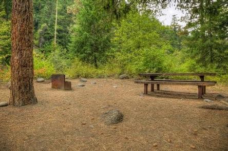
WA · Campground
Overview Willows Campground sits on the eastern slopes of the Cascade Mountains at the southern end of the Okanogan-Wenatchee National Forest, offering visitors some of the most stunning scenery in Washington and easy access to an abundance of recreational activities. Recreation In addition to being a prime location for hiking fishing, hunting, horseback riding, and mountain biking in summer and early fall, Willows Campground offers excellent skiing, snowshoeing and snowmobiling in the winter months. Hikers and backpackers are especially fortunate to have access to a variety of spectacular trails near the campground and in the surrounding areas. Designated Wilderness provides thousands of pristine acres of incredible landscapes to enjoy in solitude or with a small group. Whitewater paddling on the Tieton River, adjacent to Willows Campground, is also a popular activity. Facilities In addition to being a prime location for hiking fishing, hunting, horseback riding, and mountain biking in summer and early fall, Willows Campground offers excellent skiing, snowshoeing and snowmobiling in the winter months. Hikers and backpackers are especially fortunate to have access to a variety of spectacular trails near the campground and in the surrounding areas. Designated Wilderness provides thousands of pristine acres of incredible landscapes to enjoy in solitude or with a small group. Whitewater paddling on the Tieton River, adjacent to Willows Campground, is also a popular activity. Natural Features Encompassing more than 4 million acres and stretching north to south from the Canadian border to the Goat Rocks Wilderness, the Okanogan-Wenatchee is a stunning and diverse National Forest. High, glaciated alpine peaks tower along the Cascade Crest and lush valleys of old growth forest define its western boundary. At its eastern edge, rugged shrub-steppe country comprises a more arid region. Elevations range from below 1,000 feet to more than 9,000 feet. Visitors to the area can expect many days of clear, sunny weather in the summer, and winters with clear skies and plenty of snow. contact_info This location has limited staffing. Please call (661) 702-1420 for general information. Nearby Attractions A historic highlight of the area is the last remaining lookout in the Naches Ranger District, Jumpoff Lookout. Visitors will also enjoy traveling the Cascade Lakes Scenic Byway, which climbs into the clouds on a 66-mile drive through the Cascade Mountain range, weaving through snow-capped peaks and alpine lakes. Charges & Cancellations Cancellations Individual Campsites: Cancellations up to 2 days before a reservation start date incur a $10.00 cancellation fee. A visitor who cancels a reservation the day before or on the day of arrival will pay a $10.00 service fee AND forfeit the first night's use fee including tax and applicable add-on for a campsite. Cancellations for a one-night reservation will forfeit the entire amount paid and will not be subject to an additional service fee. No-Shows A no-show visitor is one who does not arrive at a campground and does not cancel the reservation by check-out time on the day after the scheduled arrival date. Staff will hold a campsite until check-out time on the day following the arrival date. No-shows are assessed $20.00 service fee and forfeit the first night's rate, taxes and applicable add-on for a campsite. Refunds Visitors may submit a refund request through their Recreation.gov profile within 7 days of the end date of their reservation. Refunds will not be issued after the 7 days has ended. Refunds for debit or credit card payments will be issued as a credit to the original bank or credit card used to pay. For check or cash purchases, Recreation.gov will mail a Treasury check for refunds of cash, check, or money order payments to the address associated with the reservation. Treasury check refunds may take up to 6-8 weeks to arrive. In the event of an emergency closure, the Recreation.gov team or facility manager will refund all fees and will attempt to notify you using the contact information within the Recreation.gov visitor profile.
View details →Planning tips
Camping near Mount Rainier
When is the best time to camp near Mount Rainier?
Peak season varies, but summer (June–August) is the busiest time near Mount Rainier National Park. For fewer crowds and pleasant weather, consider shoulder seasons — late May or September–October. Check seasonal road closures before planning your trip.
Should I make a reservation?
Campgrounds near popular national parks fill up fast, especially on weekends and holidays. Reserve as early as possible — some sites open reservations 6 months in advance. First-come, first-served sites may be available on weekdays.
How far are these campgrounds from Mount Rainier?
The closest campground is about 6 mi away. Most campgrounds on this page are within a 30–50 mile drive of Mount Rainier National Park.
Keep exploring