
Campgrounds in Michigan
Camp along the Great Lakes and amid beautiful forests in the Great Lakes State
53
Campgrounds listed
100%
With photos
100%
Detailed descriptions
Campground
Top campground type
Highlights
Featured campgrounds in Michigan
Explore by campground name letter
Jump to A-Z landing hubs for stronger discovery paths beyond Michigan.
All campgrounds
Showing 53 campgrounds

Overview Planning a trip to the Lake Ottawa Campground? Watch for Alerts at the top of the page for any Alerts regarding this facility. Lake Ottawa Campground is in a beautiful forested northwoods setting located 5 miles southwest of Iron River, MI, on the Iron River Ranger District. Recreation Located adjacent to the Campground is Lake Ottawa, a deep cold water lake that provides fishermen with a good variety of game fish. There is a boat ramp with ample parking for trailers. Ge-Che Trail - Length is approximately 9 miles on a dirt trail. This trail provides scenery of primarily hardwood forest. The trail can be accessed from Lake Ottawa boat landing, and from within the campground. Lake Ottawa Recreation Area day use area provides indoor facilities for a group picnic, and a large outdoor picnic area complete with picnic tables and grills. The area is large enough to provide plenty of space for all. Also located in the same area is an athletic field. The day use building provides indoor seating for eating or parties. The building has a fireplace, electricity, and flush toilets. Facilities Located adjacent to the Campground is Lake Ottawa, a deep cold water lake that provides fishermen with a good variety of game fish. There is a boat ramp with ample parking for trailers. Ge-Che Trail - Length is approximately 9 miles on a dirt trail. This trail provides scenery of primarily hardwood forest. The trail can be accessed from Lake Ottawa boat landing, and from within the campground. Lake Ottawa Recreation Area day use area provides indoor facilities for a group picnic, and a large outdoor picnic area complete with picnic tables and grills. The area is large enough to provide plenty of space for all. Also located in the same area is an athletic field. The day use building provides indoor seating for eating or parties. The building has a fireplace, electricity, and flush toilets. Nearby Attractions Stateline-Mile Post Zero Trail - Scenery is hardwood, forested with two destination points on the Brule River. The trail is not a loop, it is a relatively flat dirt trail. The length of the trial is approximately 4/10 of a mile and takes you to the historic Stateline Mile Post Zero location indicating the border between Michgian and Wisconsin. The combination of topography and thousands of miles of rivers and streams have created hundreds of waterfalls throughout the Upper Peninsula, with several of the waterfalls located on the Ottawa. The Ottawa National Forest has 18 named waterfalls, 53,637 acres of lakes, 2,366 miles of perennial streams, 2,890 miles of intermittent (occasional) streams, and 210,761 acres of wetlands. The falls vary in size and some are easier to get to than others. For more information on the most visited waterfalls on and around the Ottawa National Forest, visit the Ottawa National Forest website waterfall page .
View details →
Overview Wagner Lake Campground is a small but popular 12 site campground set on the banks of Wagner Lake. This shallow lake is surrounded by National Forest System lands. Recreation Water Activities: Wagner Lake provides visitors with an area for beach play and swimming. Visitors may also carry-in non-motorized watercraft such as canoes and kayaks for use on Wagner Lake. Fishing: Anglers can try their luck fishing from shore, a boat, or wadding into the lake. Wagner Lake has excellent bass and pan fish fishing. Facilities Wagner Lake Campground has handpump wells for drinking water, vault toliets, and garbage collection services. Each campsite has a picnic table, a campfire ring, a lantern post, and a paved parking pad. Natural Features Wagner Lake Campground is surrounded by a mixed hardwood forest. Wagner Lake is shallow sandy bottom lake. contact_info This location is unstaffed. To speak with our main office for general information, please call: (989) 826-3252. Charges & Cancellations All reservation changes, cancellations, and refunds are managed through Recreation.gov.
View details →
Overview Island Lake Campground is a popular campground and picnic area featuring a swimming beach marked with buoys on the 58-acre Island Lake. Located on the southern edge of the Mio Ranger District of the Huron-Manistee National Forest, this site is a short drive North on M-33 from Rose City, MI. This site is gated in the off-season. Island Lake Brochure and Map. Recreation Water Activities: Island Lake is a popular location for swimming, fishing, and non-motorized boating. The water tempurate is cold with a maximum depth of 25 feet. Anglers can expect to catch sunfish, perch, and bass. Visitors can carry-in kayaks, canoes, and other non-motorized watercraft a short distance from the day use parking area to day use beach. Hiking: There is a 1.25 mile loop trail that departs from the campground. A spur trail off the main loop connects Island Lake Campground with Loon Lake Day Use Area. OHV Riding: Nearby M-33 trailhead provides OHV riders with access to the Mack Lake Motorized Trail System and the Bull Gap Hill Climb Area . Additionally, a large majority of Forest Service roads are open to OHV use. Please refer to the motor vehicle use map (MVUM) to understand which roads are open to OHV use. Facilities The campground provides handpump wells for drinking water, several vault toilets, and trash collection services. The embedded day use area also provides visitors with picnic tables and grills. Campsites at Island Lake have paved parking pads, picnic tables, campfire rings, and lantern posts. Natural Features Island Lake is a small, sheltered lake. It's namesake Island is visable from the day use area. Several of the campsites offer views of Island Lake through the trees. The forest around the campground is mixed hardwoods with many wildlife and waterfowl viewing opportunites. Island Lake and the surrounding landscape are the result of glacial retreat and showcases some of Michigan's geologic history. While retreating from Michigan, glaciers left behind a pattern of broad ridges, called moraines. A chaotic arragnement of deep circular depressions and winding ridges, the Island Lake campground and Island Lake nature trail takes visitors through part of the West Branch Morraine. contact_info This location is unstaffed. To speak with our main office for general information, please call: (989) 826-3252. Charges & Cancellations All reservation changes, cancellations, and refunds are managed through Recreation.gov.
View details →
Overview Gabions Campground offers camping on the National Scenic stretch of the Au Sable River. Natural springs are common on this section of the river, including a small one at the river's edge near the gabions. Gabions are rock-filled wire baskets that are placed along the riverbank to help reduce erosion. The Shore-to-Shore Trail passes near the campground; however, Gabions is not a designated horse camp and horse camping is not permitted. Wildlife and waterfowl viewing opportunities exist; please respect wildlife and observe from a distance. Recreation Water Activites: Anglers can boat, wade, and fish from shore. Fish species found in the Au Sable River include bass, pike, brown trout, walleye, perch, sunfish, steelhead, and salmon. The water flows at a speed of 2 mph. The Au Sable River provides opportunities for non-motorized boating using watercraft such as canoes, kayaks, and rafts. 4001 Canoe Access is a short drive and provides developed access to the Au Sable river. Alcona Canoe Rental in nearby Glennie and Hinchman's Acres Resort in Mio provide watercraft rentals for canoes, kayaks, and tubes. Hiking: Visitors can walk the Shore-to-Shore Horse Trail which passes through the campground. This trail is open to hiking and horseback riding. Hikers should be aware this is not a loop trail. Additionally, hikers can drive southwest on Au Sable River road to reach the Ruffed Grouse trail head for a short leasurely 0.6 mile loop through the forest. OHV Riding: An OHV trail utilizes Au Sable River road at the mouth of the campground road. Taking the trail to the east will connect riders to the Alcona ATV Trail and taking the trail to the west will connect riders to to the Mack Lake Motorized Trail System and the Bull Gap Hill Climb Area . Additionally, a large majority of Forest Service roads are open to OHV use. Please refer to the motor vehicle use map (MVUM) to understand which roads are open to OHV use. Facilities Amenities available include a vault toilet and trash collection. There is no water provided in the campground. Campsites are equipped with picnic tables, campfire rings, and lantern posts. Natural Features The Au Sable River is a short walk from the campground where visitors can experience world class fishing and floating opportunities. Each site is shaded by a mixed forest of hardwoods, red pines, and jack pine. contact_info This location is unstaffed. To speak with our main office for general information, please call: (989) 826-3252.
View details →
Overview As visitors exit McKinley Road to enter the Au Sable Loop Scenic Overlook, they will first see a panoramic vista of the National Scenic portion of the Au Sable River. From the Au Sable Loop Scenic Overlook follow the unpaved road to reach the campground. The small five site campground is set amidst a mixed hardwood forest. The campground and day use areas are ideal for scenery viewing, wildlife viewing, and picnicking. Recreation Water Activities: The Au Sable Loop Campground provides forest visitors with a variety of water activities. Access to the Au Sable River is afforded by a short path from the campground. Anglers can boat, wade, and fish from shore. Fish species found in the Au Sable River include bass, pike, brown trout, walleye, perch, sunfish, steelhead, and salmon. The water flows at a speed of 2 mph. The Au Sable River provides opportunities for non-motorized boating using watercraft such as canoes, kayaks, and rafts. Watercraft can be rented in Mio at Hinchman’s Acres Resort or at Alcona Canoe Rental in Glennie. Hiking: Along the north side of the river is the 0.5 mile Mio Nature Trail with a trailhead located in the Mio Ranger Station parking lot. Along the south side of the river is the 4.5 mile Wolf Creek Trail . The trailhead for Wolf Creek is on the lefthand side 1 mile west of Mio down South River road. Both trails provide views of the Au Sable River and are appropriate for a variety of skill levels. Facilities Water Activities: The Au Sable Loop Campground provides forest visitors with a variety of water activities. Access to the Au Sable River is afforded by a short path from the campground. Anglers can boat, wade, and fish from shore. Fish species found in the Au Sable River include bass, pike, brown trout, walleye, perch, sunfish, steelhead, and salmon. The water flows at a speed of 2 mph. The Au Sable River provides opportunities for non-motorized boating using watercraft such as canoes, kayaks, and rafts. Watercraft can be rented in Mio at Hinchman’s Acres Resort or at Alcona Canoe Rental in Glennie. Hiking: Along the north side of the river is the 0.5 mile Mio Nature Trail with a trailhead located in the Mio Ranger Station parking lot. Along the south side of the river is the 4.5 mile Wolf Creek Trail . The trailhead for Wolf Creek is on the lefthand side 1 mile west of Mio down South River road. Both trails provide views of the Au Sable River and are appropriate for a variety of skill levels. Natural Features Located near the banks of the National Scenic Au Sable River, this campground is a haven for water based recreation. An exemplary setting for wildlife viewing, visitors and campers will see a melding of habitats as the river turns to forest and then to field. The area is inhabited by bald eagles, deer, bear, bobcat, porcupine, various songbirds, and waterfowl. Please respect wildlife and observe from a distance. contact_info This location is unstaffed. To speak with our main office for general information, please call: (989) 826-3252. Charges & Cancellations All reservation changes, cancellations, and refunds are managed through Recreation.gov.
View details →
Overview Meadows ORV Campground is a small, 13 single site area primarily used by OHV riders. The sites accomodate trailers/RV's up to 25 feet in length. Recreation ORV Riding: Passing just long the south edge of the campground is the Meadows ORV Trail System . This trail system was developed for vehicles 50 inches of less. The Meadows ORV trail connects to the Mack Lake Trail System and Bull Gap Hill Climb . The trail ranges anywhere from 0 to 10% grades with some short stretches of 30%. Confidence markers are orange triangles. Facilities Meadows ORV Campground provides visitors with a handpump well for drinking water, several vault toliets, and garbage collection services. Individual campsites provide a picnic table, a campfire ring, and a lantern post. Natural Features Meadows ORV Campground is nestled amoungst a pine and hardwood forest. The west branch of Big Creek is crossed by Meadows West Trail just to the southwest of the campground. Meadows ORV Campground is isolated from nearby light sources making it an excellent location for star gazing. contact_info This location is unstaffed. To speak with our main office for general information, please call: (989) 826-3252. Charges & Cancellations All reservation changes, cancellations, and refunds are managed through Recreation.gov.
View details →
Overview Grand Island is located in Lake Superior, about one-half mile from the mainland community of Munising, Michigan. Munising is about 43 miles from Marquette and 55 miles from Manistique. Grand Island is the perfect place to spend a day or even just a few hours biking and exploring. The island's breathtaking overlooks, pristine sandy beaches, fascinating cultural sites, deep hard woods, and inland lakes make it an exciting and secluded destination. Recreation Group and indvidiual camping, biking, hiking, ice climbing, swimming, boating, hunting, fishing, and site seeing can all be enjoyed on Grand Island Facilities Group and indvidiual camping, biking, hiking, ice climbing, swimming, boating, hunting, fishing, and site seeing can all be enjoyed on Grand Island Natural Features Grand Island National Recreation Area Campground part of the Hiawatha National Forest, near Michigan's Upper Peninsula. Calm waters, 300 foot sandstone cliffs, and white-sand beaches beckon boaters and swimmers to the area. Nearby Attractions Pictured Rocks National Lakeshore, Hiawatha National Forest, and the City of Munising. The Munising Area provides a variety of restaurants, hotels, camping opportunities and outfitters. Local outfitters provide guided and self-guided kayak, canoe, pontoon and mountain bike rentals. Charges & Cancellations see recreation.gov policy
View details →
Overview Mack Lake ORV Campground is the largest campground on the Mio Ranger District. Southeast of Mio, Mack Lake is 175-acres of shared private and federal ownership. An embedded day use area provides visitors with a picnic area as well as water access and a swimming area surrounded by bouys. With an ORV trailhead located within the campgroud, Mack Lake ORV Campground is a popular location for ORV trail riders. Recreation Water Activities : A day use area inside the Beaver Loop of Mack Lake ORV Campground is designed for picnicing and water activities such as beach play, swimming, fishing, and boating. Carry-in boat access is available through the day use area. Anglers can hope to catch sunfish, perch, and walleye. ORV Riding : Mack Lake ORV Campground is a popular location with ORV riders. With the trailhead for the Mack Lake Trail System starting in the campground, ORV riders can enjoy the section near Maltby Hills for easier trail riding or head to Bull Gap Hill Climb for a challenge. The trail is mostly on a 0 - 10% grade, with some short sections at a 30% grade Facilities Water Activities : A day use area inside the Beaver Loop of Mack Lake ORV Campground is designed for picnicing and water activities such as beach play, swimming, fishing, and boating. Carry-in boat access is available through the day use area. Anglers can hope to catch sunfish, perch, and walleye. ORV Riding : Mack Lake ORV Campground is a popular location with ORV riders. With the trailhead for the Mack Lake Trail System starting in the campground, ORV riders can enjoy the section near Maltby Hills for easier trail riding or head to Bull Gap Hill Climb for a challenge. The trail is mostly on a 0 - 10% grade, with some short sections at a 30% grade Natural Features The 175-acre lake is surrounded by rolling jack pine plains and is a good location for wildlife viewing. Nearby Attractions contact_info This location has limited staffing. Please call (989) 826-3252 for general information. Charges & Cancellations All reservation changes, cancellations, and refunds are managed through Recreation.gov.
View details →
Overview White Pine Backcountry Campground is a primitive camp located in the southern district of Sleeping Bear Dunes National Lakeshore, on the lower peninsula of Michigan. It is located approximately two miles from the Trail's End Road trailhead on the Platte Plains hiking trail south of Empire just off of M-22. This year-round campground has six campsites, two shared fire rings, pit toilet, and two shared animal resistant food storage lockers. Plan to pack your water into the campsite, as there is no well in the campground. Summer temperatures range from upper 70s to 90 degrees F (25° to 32° C) during the day, and from the 50s to 70 degrees F (10° to 25° C) at night. Winters are cold, with daytime highs from 20° to 30° F (-7° to -1° C) and lows in the 10s and 20s F (-12° to -7° C). Snow is usually on the ground from late November through March. Recreation The Platte Plains trail system boasts more than 25 miles (40 km) of trails, some of which can be accessed a short walk away from the campground. Facilities The Platte Plains trail system boasts more than 25 miles (40 km) of trails, some of which can be accessed a short walk away from the campground. Natural Features The campground is within wilderness. Designated Wilderness areas are the most protected public lands in America. They are managed with restraint to preserve characteristics of wilderness and solitude. The Sleeping Bear Dunes Wilderness, within the boundaries of the Lakeshore, is over 30,000 acres. The beaches of Lake Michigan are about 1/2 mile (0.80 km) walk from camp. Although the lakeshore is long and narrow, it has northern hardwood and conifer forests, abandoned farm meadows, wetlands, lakes, streams, bogs, and splended examples of glacially formed landscape. The most prominent features in the park, and those for which it is named, are perched sand dunes above Lake Michigan. The overlooks at Sleeping Bear, Empire and Pyramid Point bluffs are about 400 feet (122 m) above the lake. Within 65 miles (105 km) of Lake Michigan shoreline and numberous inland lakes and streams, the park is wonderfully water-oriented.
View details →
Overview Flowing Well Campground is situated along the western banks of the Sturgeon River, among large trees and a variety of wildflowers. Camping, fishing, picnicking and canoeing can be enjoyed in a serene setting. Recreation The area is most popular for canoeing and other non-motorized boating, as the Sturgeon River Canoe Trail runs right through the campground. The trail weaves with the river through a 41-mile portion of the heavily wooded Hiawatha National Forest. There are various access points along the river. Fishing is also popular, with brook trout, steelhead and salmon found in the river. Facilities The area is most popular for canoeing and other non-motorized boating, as the Sturgeon River Canoe Trail runs right through the campground. The trail weaves with the river through a 41-mile portion of the heavily wooded Hiawatha National Forest. There are various access points along the river. Fishing is also popular, with brook trout, steelhead and salmon found in the river. Natural Features The campground is sandwiched between Forest Highway 13 and the Sturgeon River, in the lower portion of Michigan's Upper Peninsula. It is about 10 miles from the northern shores of Lake Michigan. The region is dotted with wildflowers and mature trees.
View details →
Overview Little Bay Campground provides a quiet respite from more developed campgrounds in the area. It has long been a favorite for visitors seeking solitude. Beautiful sunsets can be seen over the glistening water of the Little Bay de Noc, and campers enjoy water activities on the lake. Recreation The bay is widely recognized as one of the finest walleye fisheries in the country. The Hunter's Point paved boat ramp is located less than a mile from the entrance of the campground. Other than fishing, visitors enjoy non-motorized boating and swimming, or simply enjoying the beach. A variety of hiking trails are also within a couple miles of the campground. Facilities The bay is widely recognized as one of the finest walleye fisheries in the country. The Hunter's Point paved boat ramp is located less than a mile from the entrance of the campground. Other than fishing, visitors enjoy non-motorized boating and swimming, or simply enjoying the beach. A variety of hiking trails are also within a couple miles of the campground. Natural Features The campground sits on the shore of Little Bay de Noc, on the north end of Lake Michigan. A group camping area is separated from the other sites with oak, hemlock and hardwood trees, providing a relatively private camping experience.
View details →
Overview Camp Seven Lake Campground neighbors the 60-acre Camp Seven Lake, which offers visitors a place to swim, boat and fish. The excellent location, beautiful setting and many available activities make the campground a perfect place to spend a day, the weekend or longer vacation. Recreation Boating is popular among visitors to the Camp Seven Lake area, and anglers looking to find that perfect spot on the lake. Smallmouth bass, bluegills and perch make up the most popular catches. The 2-mile Van Winkle Lake loop trail leads hikers to a spectacular paper birch stand overlooking quiet Van Winkle Lake. A variety of waterfowl and wetland wildlife can be spotted along the trail. For a more relaxing stroll, the beach at Camp Seven Lake boasts a paved walking trail. Facilities Boating is popular among visitors to the Camp Seven Lake area, and anglers looking to find that perfect spot on the lake. Smallmouth bass, bluegills and perch make up the most popular catches. The 2-mile Van Winkle Lake loop trail leads hikers to a spectacular paper birch stand overlooking quiet Van Winkle Lake. A variety of waterfowl and wetland wildlife can be spotted along the trail. For a more relaxing stroll, the beach at Camp Seven Lake boasts a paved walking trail. Natural Features The campground is adjacent to Camp Seven Lake, which is situated in the lower third of the Hiawatha National Forest, in Michigan's Upper Peninsula. The area is home to many bodies of water and plentiful mixed hardwood forests. Nearby Attractions The town of Garden Corners is about 20 miles from the campground, on the shores of Lake Michigan.
View details →
Overview Colwell Lake Campground is situated on Colwell Lake in the center of Michigan's Hiawatha National Forest. Guests of all ages can enjoy nature and the outdoors in this picturesque setting. The campground has much to offer in terms of recreation, such as swimming, fishing, boating and picnicking, and can accommodate families, individuals, small groups, RV and tent campers with several amenities. Recreation With an excellent swimming beach, boat access and an accessible fishing pier, Colwell Lake has plenty to offer families and anglers. Largemouth bass, northern pike, crappie, pumpkinseed sunfish, perch and bluegill are all available in the lake. The facility also provides a leisurely 2 mile hiking and snowshoeing trail. Facilities With an excellent swimming beach, boat access and an accessible fishing pier, Colwell Lake has plenty to offer families and anglers. Largemouth bass, northern pike, crappie, pumpkinseed sunfish, perch and bluegill are all available in the lake. The facility also provides a leisurely 2 mile hiking and snowshoeing trail. Natural Features The campground is situated on Michigan's Upper Peninsula, on the eastern shore of the 145-acre Colwell Lake. The area is forested with a variety of deciduous and conifer trees, and some campsites overlook the water. Nearby Attractions Big Island, Fish and Straits lakes are all within 25 miles of the campground.
View details →
Overview South Manitou Group Campground is a tent-only backcountry facility on South Manitou Island in Sleeping Bear Dunes National Lakeshore on Lake Michigan. Campers must take a 1.5-hour Manitou Island Transit Ferry trip or boat ride to reach it, and must backpack their gear into the campground from the dock. **Booking for individual sites on South Manitou Island are made on a first come/first served basis directly through Manitou Island Transit .** This facility is comprised of three reservable group sites at Bay Campground and three others at Weather Station Campground. Each site is open to groups of nine to 20 people only. Smaller parties must plan to occupy multiple first-come, first-served individual sites at Popple, Bay or Weather Station Campgrounds on the island. Bay is the closest campground to the dock (less than a mile/1.6 km) and a short walk from the beach. Weather Station overlooks Lake Michigan from the bluffs on the south side of the island; the hike from the ferry is about 1.3 miles (2 km). If group sites are full, your group may be able to split up into multiple individual campsites. Be sure to book reservations on the Manitou Island Transit website or call (231) 256-9061 for transportation to the island. Or contact Sleeping Bear Dunes for more information at (231) 326-4700 ext 5010. Summer temperatures range from the upper 70s to 90 degrees F (25° to 32° C) during the day, and from the 50s to 70 degrees F (10° to 25° C) at night. Winters are cold, with daytime highs from 20° to 30° F (-7° to -1° C) and lows in the 10s and 20s F (-12 to -7° C). Snow is usually on the ground from late November through March. Recreation There is no shortage of activities on South Manitou Island. Visitors can hike around the 10-mile perimeter of the island via pebble beaches, take a tour of the South Manitou Island Lighthouse during summer months, view the 1960 shipwreck of the Francisco Morazanon or go on a motorized tour to learn the history of the island. Visitors can also hike day-long excursions to unique sand dune formations and old growth cedar forests. Both campgrounds have beach access where campers can beachcomb and swim; group sites are closer to the beach at Bay Campground than at Weather Station. Facilities There is no shortage of activities on South Manitou Island. Visitors can hike around the 10-mile perimeter of the island via pebble beaches, take a tour of the South Manitou Island Lighthouse during summer months, view the 1960 shipwreck of the Francisco Morazanon or go on a motorized tour to learn the history of the island. Visitors can also hike day-long excursions to unique sand dune formations and old growth cedar forests. Both campgrounds have beach access where campers can beachcomb and swim; group sites are closer to the beach at Bay Campground than at Weather Station. Natural Features South Manitou Island is part of an island chain in Lake Michigan that extends north to the Straits of Mackinac. The island consists of a ridge of tilted layers of limestone, buried under a blanket of glacial debris. It features unique sand dune formations, 10 miles of pebble beaches and a grove of old growth white cedars that date back over 500 years. The campgrounds lie on sandy soils among younger forests. contact_info For local information, please call (231) 326-4700 or call (877) 444-6777 for general information.
View details →
Overview D.H. Day Group Campground is a tent-only facility located in the heart of Sleeping Bear Dunes National Lakeshore, about one mile (1.6 km) north of the Dune Climb, where visitors can walk over miles of sand dunes. This year-round campground has four sites which accommodate groups of 7 to 25 people. Recreation D.H. Day Group is a hub for water activities. Motorized and non-motorized boating is allowed on the lake, with restrictions, and there is a boat ramp about six miles away by which boaters can access Lake Michigan. Campers can also rent canoes and kayaks in the town of Glen Harbor to float the nearby Crystal River. The beach at Glen Haven, which is popular for beachcombing and swimming, is about one mile away from the campground. There are no lifeguards on duty at the park's beaches. The facility is also close to the Dune Climb, where visitors can climb on sand dunes over 200 feet high, walk more than 1.5 miles on the dunes to Lake Michigan and catch a great view of Glen Lake. Facilities D.H. Day Group is a hub for water activities. Motorized and non-motorized boating is allowed on the lake, with restrictions, and there is a boat ramp about six miles away by which boaters can access Lake Michigan. Campers can also rent canoes and kayaks in the town of Glen Harbor to float the nearby Crystal River. The beach at Glen Haven, which is popular for beachcombing and swimming, is about one mile away from the campground. There are no lifeguards on duty at the park's beaches. The facility is also close to the Dune Climb, where visitors can climb on sand dunes over 200 feet high, walk more than 1.5 miles on the dunes to Lake Michigan and catch a great view of Glen Lake. Natural Features The campground is open with sparse vegetation. Contrary to the park's name, bears are rarely sighted here, yet other wildlife such as birds, deer and wild turkey may be seen. Although the Lake Michigan shore is long and narrow, it has northern hardwood and conifer forests, abandoned farm meadows, wetlands, lakes, streams, bogs and splendid examples of a glacially formed landscape. The most prominent features in the park, for which it was named, are the perched sand dunes above Lake Michigan. The overlooks at Sleeping Bear, Empire and Pyramid Point bluffs are about 400 feet above the lake. With 65 miles of Lake Michigan shoreline and numerous inland lakes and streams, the park is wonderfully water-oriented. contact_info For local information, please call (231) 326-4700 or call (877) 444-6777 for general information. Nearby Attractions The historic area of Glen Haven, which features a working blacksmith shop, a 1920s-era general store and Sleeping Bear Point Maritime Museum, is within a short drive of the campground. Charges & Cancellations
View details →
Overview Platte River Campground is located in the southern district of Sleeping Bear Dunes National Lakeshore, on the lower peninsula of Michigan. This year-round facility is one of the most popular campgrounds in the park. It is within walking distance of the Platte River and a short walk or drive away from the Lake Michigan shore. Hikers can access many of the area's day use and backpacking trails just north of the campground. Summer temperatures range from the upper 70s to 90 degrees F (25° to 32° C) during the day, and from the 50s to 70 degrees F (10° to 25° C) at night. Winters are cold, with daytime highs from 20° to 30° F (-7° to -1° C) and lows in the 10s and 20s F (-12 to -7° C). Snow is usually on the ground from late November through March. Recreation Campers can hike, canoe, kayak and fish on the river or the lake. There are canoe rentals at nearby Platte River Point, where the river meets the lake (the point also has beach access for those wishing to drive there). The Platte Plains trail system boasts more than 25 miles (40 km) of trails, some of which can be accessed a short walk away from the campground. Trails to the primitive White Pine backcountry campground are also close by. Facilities Campers can hike, canoe, kayak and fish on the river or the lake. There are canoe rentals at nearby Platte River Point, where the river meets the lake (the point also has beach access for those wishing to drive there). The Platte Plains trail system boasts more than 25 miles (40 km) of trails, some of which can be accessed a short walk away from the campground. Trails to the primitive White Pine backcountry campground are also close by. Natural Features The campground lies in a wooded area within walking distance of the Platte River and less than two miles (3.2 km) away from the beaches of Lake Michigan. Although the lakeshore is long and narrow, it has northern hardwood and conifer forests, abandoned farm meadows, wetlands, lakes, streams, bogs and splendid examples of a glacially formed landscape. The most prominent features in the park, and those for which it is named, are the perched sand dunes above Lake Michigan. The overlooks at Sleeping Bear, Empire and Pyramid Point bluffs are about 400 feet (122 m) above the lake. With 65 miles (105 km) of Lake Michigan shoreline and numerous inland lakes and streams, the park is wonderfully water-oriented. contact_info For local information, please call (231) 326-4700 or call (877) 444-6777 for general information. Charges & Cancellations
View details →
Overview Planning a visit to the Black River Harbor Pavilion? Watch for Alerts at the top of the page for any Alerts regarding this facility. The Black River Harbor Pavilion is located within the Black Harbor Recreation Area on Lake Superior in Michigans Upper Peninsula. The historic stone and wood pavilion was constructed by the Civilian Conservation Corps in the 1930s. Recreation Lake Superior offers great opportunities for boating, fishing, and swimming. The North Country National Scenic Trail, which traverses through the recreation area, offers access to all five waterfalls and a scenic 12 mile hike to the Porcupine Mountain Wilderness State Park in Michigan. The Black River Harbor Boating Club sponsors an annual fishing derby over Labor Day weekend. Facilities Lake Superior offers great opportunities for boating, fishing, and swimming. The North Country National Scenic Trail, which traverses through the recreation area, offers access to all five waterfalls and a scenic 12 mile hike to the Porcupine Mountain Wilderness State Park in Michigan. The Black River Harbor Boating Club sponsors an annual fishing derby over Labor Day weekend. Natural Features Visitors enjoy boating, fishing, hiking, swimming, and viewing waterfalls. The Black River Harbor Recreation Area has docking and fuel services for day and transient boaters, a boat launch, a large picnic area with a swing set, a campground with 39 campsites, beach access to Lake Superior, and five scenic waterfalls along the wild and scenic Black River. The day-use picnic area has a suspension bridge over the Black River with a hiking trail to a beautiful sand and pebble beach on Lake Superior. The campground is situated among hemlock and pine trees at an elevation of 840 feet, on a bluff overlooking Lake Superior and offers a scenic overlook of Lake Superior's Apostle Islands. The Ottawa National Forest encompasses nearly one million acres on the west side of Michigan's Upper Peninsula. The forest extends from the south shore of Lake Superior to the Wisconsin border. It is distinguished by rolling hills dotted with lakes, rivers and waterfalls. Nearby Attractions For a panoramic view of the area, visit Copper Peak International Ski Flying Hill, a 17-story steel ski jump. Visitors can take an elevator up to the top. The attraction is a short drive from the campground. The Porcupine Mountain Wilderness State Park in Michigan can be seen in the distance from the beach and is less than a one-hour drive from the Harbor. Charges & Cancellations Cancellations If you cancel reservation at least 14 days prior to check in date, all recreation fees, minus a $10 cancellation fee and the reservation fee ($8 if made online or $9 if made through the call center) will be refunded. If you cancel reservation less than 14 days prior to check in date, you forfeit the entire total paid. No Show Staff will hold facility until check-in time on the arrival date. For more information about rules and reservation policies, visit the Recreaiton.gov Rules and Reservations Policy page .
View details →
Overview Located at the south end of AuTrain Lake, this campground is favored by anglers and outdoor enthusiasts. The quiet setting is great for family trips, and visitors can enjoy a variety of recreational opportunities year-round, all less than a day's drive from major urban areas of Michigan and Wisconsin. Recreation The large size of the lake provides miles of prime water skiing, boating, swimming and fishing. Anglers can expect a healthy catch of bass and a variety of perch. Canoeing is also popular on AuTrain Lake and the nearby AuTrain River, which meanders into Lake Superior. The campground also provides access to the popular two-mile Songbird interpretive trail, which winds through forest and field, along bog and lakeshore, and is popular for birding. A wildlife viewing platform is available at neighboring Buck Bay and Buck Bay Creek. Facilities The large size of the lake provides miles of prime water skiing, boating, swimming and fishing. Anglers can expect a healthy catch of bass and a variety of perch. Canoeing is also popular on AuTrain Lake and the nearby AuTrain River, which meanders into Lake Superior. The campground also provides access to the popular two-mile Songbird interpretive trail, which winds through forest and field, along bog and lakeshore, and is popular for birding. A wildlife viewing platform is available at neighboring Buck Bay and Buck Bay Creek. Natural Features AuTrain Lake is located in the upper peninsula of Michigan, between three of the Great Lakes. It sits amid rolling hills forested with pine and aspen trees, as well as large open and tree-covered wetlands. Nearby Attractions The city of AuTrain, located on the shores of Lake Superior, is about 5 miles from the campground.
View details →
Overview Bay Furnace Campground is located on the south shores of Lake Superior, near Pictured Rocks National Lakeshore. Favorite to many, the campground is centered to various waterfalls, as well as other sightseeing attractions, including boat tours and visits to Grand Island. Recreation Fishing in Lake Superior is best by boat. There is no access to the lake at Bay Furnace, but there is a boat ramp approximately 10 miles west, at AuTrain, and in Munising. Anglers can enjoy a variety of lake trout and salmon fishing. Visitors can access the popular Grand Island via a 10-minute ferry ride or by private boat. This scenic island is a favorite for hiking, mountain biking and exploring. Various boat excursions are offered near the campground at an additional cost, providing a great way to explore the crystal clear blue-green waters of Lake Superior and view the stunning natural rock formations. Facilities Fishing in Lake Superior is best by boat. There is no access to the lake at Bay Furnace, but there is a boat ramp approximately 10 miles west, at AuTrain, and in Munising. Anglers can enjoy a variety of lake trout and salmon fishing. Visitors can access the popular Grand Island via a 10-minute ferry ride or by private boat. This scenic island is a favorite for hiking, mountain biking and exploring. Various boat excursions are offered near the campground at an additional cost, providing a great way to explore the crystal clear blue-green waters of Lake Superior and view the stunning natural rock formations. Natural Features Visitors can enjoy the scenic views of Lake Superior, with its spectacular sunrises, sunsets and occasional northern lights displays. Amid forests of deciduous trees, some sites overlook the lake while others are near Furnace Creek. Nearby Attractions Boat ramps are available in Munising, less than 5 miles from the campground, or at AuTrain, which is about 10 miles away.
View details →
Overview Petes Lake Campground, located in the center of Michigan's Hiawatha National Forest, is surrounded by several lakes and offers excellent hiking, biking, fishing, boating and more. Snuggled amongst mixed hardwood trees, the campground offers a swimming beach and day-use picnic area away from the hustle and bustle of city life. Recreation Visitors enjoy a variety of water-related recreation opportunities. The campground also has fishing pier next to the day-use area. Anglers can expect healthy populations of northern pike, bass, walleye and perch in the lake. The nine-mile Bruno's Run Trail, which winds its way past a host of small lakes in the area, passes directly through the campground and is a popular trail for hiking and biking, as well as snowshoeing and cross-country skiing in the winter. Facilities Visitors enjoy a variety of water-related recreation opportunities. The campground also has fishing pier next to the day-use area. Anglers can expect healthy populations of northern pike, bass, walleye and perch in the lake. The nine-mile Bruno's Run Trail, which winds its way past a host of small lakes in the area, passes directly through the campground and is a popular trail for hiking and biking, as well as snowshoeing and cross-country skiing in the winter. Natural Features The campground is situated on the upper peninsula of Michigan, on the shores of the 190-acre Petes Lake. It sits amid rolling hills that are forested with a variety of deciduous and conifer trees. Many of the campsites are shaded and private. Nearby Attractions Big Island, Fish and Straits lakes are all within 25 miles of the campground.
View details →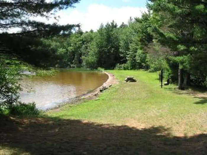
Overview The sparkling Marion Lake offers breathtaking and exciting camping for your next family trip. Live it up on the water with your jet skis or wake board, or tone down the pace with a full day of fishing. The Marion Lake Group Site is an ideal way to spend time with friends and family for all the water activities you can imagine. Marion Lake is in the Ottawa National Forest, a protected area in the Western Upper Peninsula of Michigan. It stretches from the Lake Superior shoreline to the Wisconsin border, and attracts deer and many types of migrating birds. Recreation A swim beach is adjacent to the group site. Facilities A swim beach is adjacent to the group site. Natural Features The campground is in a large, grassy field surrounded by hemlock and hardwood trees with an opening to Marion Lake. The altitude is 1,627 feet, with lightly rolling hills stretched between the many other lakes in the area. Nearby Attractions Hiking enthusiasts will find scenic trails throughout the Sylvania Wilderness area, a region to the west with old-growth forests and 34 named lakes. On the way, stop by the Ottawa Visitor Center in Watersmeet for some interesting exhibits.
View details →
Overview There are many campsites on the Munising and Rapid River/Manistique Ranger Districts of the Hiawatha National Forest. Many are located on inland lakes and are in a rustic forest environment with few to no amenities and no drinking water. The rustic environment offers a wonderfully serene and peaceful setting for your next camping experience. The Council Lake Campsites sit on the shores of Council Lake in the center of the Hiawatha National Forest. It is located amid a series of forested lakes and provides ample opportunity for visitors to enjoy nature in the scenic surroundings. Recreation Council Lake is a 12-acre lake with yellow perch, rock and largemouth bass, bluegill, black crappie, bullhead and northern pike. Licenses are required to fish in Michigan waters. Council Lake is part of a small chain of lakes and offers excellent canoeing and kayaking opportunities. There is a short portage that links Council Lake to Bar Lake and the Indian Wild and Scenic River. Non-motorized boats can be used on the lake, however access at the campground is by land only. A boat ramp can be found at adjoining Red Jack Lake. The day-use area is equipped with tables and a pedestal grill. The area is near a beach that is perfect for lounging and swimming. No drinking water is provided at the campsite; water must be brought in and garbage must be carried out. Facilities Council Lake is a 12-acre lake with yellow perch, rock and largemouth bass, bluegill, black crappie, bullhead and northern pike. Licenses are required to fish in Michigan waters. Council Lake is part of a small chain of lakes and offers excellent canoeing and kayaking opportunities. There is a short portage that links Council Lake to Bar Lake and the Indian Wild and Scenic River. Non-motorized boats can be used on the lake, however access at the campground is by land only. A boat ramp can be found at adjoining Red Jack Lake. The day-use area is equipped with tables and a pedestal grill. The area is near a beach that is perfect for lounging and swimming. No drinking water is provided at the campsite; water must be brought in and garbage must be carried out. Natural Features These four campsites are situated on the quaint 12 - acre Council Lake, nestled in a mixed stand of hardwood and pine trees. They are on the southern shores of Council Lake, close to adjoining Red Jack and Scout lakes. contact_info For local information, please call (906) 387-2512 or call (906) 474-6442 for general information.
View details →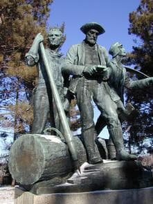
Overview Monument Campground was established in 1909 as one of the first campgrounds built in the Huron National Forest. The campground is a fully accessible camping area within a red pine plantation. Families love this conveniently located campsite, just 15 minutes from Lake Huron off the River Road National Scenic Byway. Recreation Campers can access the Highbanks Hiking Trail from the campground or explore the 22-mile River Road National Scenic Byway that overlooks the lovely AuSable River valley. Beside the campground is the Lumberman's Monument Visitor Center, replete with information about the area's rich lumbering history. Here, visitors can climb through a log jam, use a peavey, cut a wooden cookie with a cross-cut saw, and learn about the life of a lumberjack through video and displays. Facilities Campers can access the Highbanks Hiking Trail from the campground or explore the 22-mile River Road National Scenic Byway that overlooks the lovely AuSable River valley. Beside the campground is the Lumberman's Monument Visitor Center, replete with information about the area's rich lumbering history. Here, visitors can climb through a log jam, use a peavey, cut a wooden cookie with a cross-cut saw, and learn about the life of a lumberjack through video and displays. Natural Features Each site is secluded and shaded with large oak and red pine near the AuSable River. The river flows from west to east for 138 miles until it reaches the great lake, Lake Huron. Nearby Attractions Explore the many trails of the Huron-Manistee National Forests and spend time at Lake Huron.
View details →
Overview Rollways Campground is located 7 miles from Hale, Michigan along the beautiful AuSable River. The site was built in 1909 as one of the first campgrounds established in Huron National Forest. The space is small and secluded and features an observation area, picnic grounds and log shelter.. The facility is located just off the River Road National Scenic Byway in northeast Lower Michigan. The byway showcases incredible views of the AuSable River Valley. Recreation Hike on the accessible trail that connects the campground and picnic area to Westgate Scenic Overlook. Bring binoculars and a camera to take advantage of the epic view. The same hiking path passes a stairway leading down to the river where visitors can fish and wade. Facilities Hike on the accessible trail that connects the campground and picnic area to Westgate Scenic Overlook. Bring binoculars and a camera to take advantage of the epic view. The same hiking path passes a stairway leading down to the river where visitors can fish and wade. Natural Features Rollways is perched on a high bluff overlooking Loud Dam Pond on the AuSable River. The river flows from west to east for 138 miles until it reaches the great Lake Huron. Nearby Attractions Follow the length of the 22-mile River Road National Scenic Byway, which parallels the AuSable River.
View details →
Overview Peterson Bridge Campground is located on the Pine River in Michigan’s Manistee National Forest. The location on the river makes it ideal for canoeists and those looking to experience the adventure of this swift moving river. Recreation With access to the river so close, floating the Pine River is a popular activity at Peterson Bridge. Several locations near the campground offer canoe rentals. Supporting outstanding trout fishing, the Pine River is also a “Blue Ribbon” cold-water fishery. For State Fishing Regulations consult the Michigan Department of Natural Resources website, website http://www.michigan.gov/dnr/. Facilities With access to the river so close, floating the Pine River is a popular activity at Peterson Bridge. Several locations near the campground offer canoe rentals. Supporting outstanding trout fishing, the Pine River is also a “Blue Ribbon” cold-water fishery. For State Fishing Regulations consult the Michigan Department of Natural Resources website, website http://www.michigan.gov/dnr/. Natural Features The Pine River is well known as one of the most outstanding canoeing and trout fishing rivers in the Midwest. The river gradient is 7% and, depending upon the season, offers the fasted average flow of any river in lower Michigan. The lower 26 miles of the Pine River have been designated a National Wild and Scenic River.
View details →
Overview Lake Michigan Campground is perched on the shores of Lake Michigan, 15 miles south of Manistee. The area creates an incredible setting with a scenic overlook of the lake and a sandy swimming beach. This family campground provides an array of hiking and biking trails, plus swimming, fishing and kayaking. Recreation A hardwood forest gives way to a beautiful sandy beach at the shores of the lake with a playground for younger campers. Trout fishing in Lake Michigan is another big draw. Bird watchers delight in seeing unique species like the piping plover and prairie warbler. The Arrowhead Trail, a short loop trail created by Boy Scouts, forms a loop between the campground and the beach. A trailhead for the Nordhouse Dunes Wilderness Area is also within the recreation area. Facilities A hardwood forest gives way to a beautiful sandy beach at the shores of the lake with a playground for younger campers. Trout fishing in Lake Michigan is another big draw. Bird watchers delight in seeing unique species like the piping plover and prairie warbler. The Arrowhead Trail, a short loop trail created by Boy Scouts, forms a loop between the campground and the beach. A trailhead for the Nordhouse Dunes Wilderness Area is also within the recreation area. Natural Features The recreation area sits on the eastern banks of Lake Michigan along Porter Creek, due north of Hamlin Lake. As the second largest of the five Great Lakes, Lake Michigan provides stunning views and limitless options for water recreation. It covers a whopping 22,400 square miles and ranks as the fifth largest lake in the world. The Huron-Manistee National Forests encompass nearly a million acres of public protected land. Nearly 6,000 acres is wetlands that extend over the northern portion of Michigan's Lower Peninsula. Nearby Attractions The nearby Nordhouse Dunes Wilderness Area has abundant trails for hiking and backpacking.
View details →
Overview Sand Lake Campground is situated on the scenic shores of Sand Lake and provides a selection of sites shaded by a mixed hardwood forest. Just beyond the trees is a well-loved, sandy swimming beach. The campground is located 15 minutes from the Pine National Scenic River and several other lakes. The popular campground sits within the Huron-Manistee National Forests, far enough from town to let its natural splendor shine, but close enough for convenient access to gas and groceries. Recreation Power boating, sailing, canoeing, hiking and swimming are some of the most common activities on the lake. Anglers delight in the waters well-stocked with bluegill, perch and smallmouth bass. A picnic area and boat ramp are available for use. Facilities Power boating, sailing, canoeing, hiking and swimming are some of the most common activities on the lake. Anglers delight in the waters well-stocked with bluegill, perch and smallmouth bass. A picnic area and boat ramp are available for use. Natural Features Sand Lake boasts about 50 acres of mostly shallow waters. The campground is nicely wooded; some sites are heavy shaded while others are much more open. Summertime temperatures are generally around 80 degrees. The Huron-Manistee National Forests encompass nearly a million acres of public protected land, including nearly 6,000 acres of wetlands that extend over the northern portion of Michigan's Lower Peninsula.
View details →
Overview Bowman Bridge Campground is perfect for true nature immersion. Campers come here for easy access to the Pere Marquette National Scenic River and for the delightful views of the great outdoors. Recreation The top three activities for campers at Bowman Bridge are canoeing, fishing and hiking. Anglers cast for brown trout, salmon, steelhead and rainbow trout. Watercraft rentals are available at two nearby liveries in Baldwin. A permit is required to float the river from the Friday of Memorial Day weekend through Monday of Labor Day weekend. Watercraft hours during the permit season are 9 a.m. to 6 p.m. Hikers can head up the campground's connector trail to the North Country National Scenic Trail. This "north country" trail weaves through many scenic, historic and cultural areas across seven states, measuring 4,600 miles end-to-end. Facilities The top three activities for campers at Bowman Bridge are canoeing, fishing and hiking. Anglers cast for brown trout, salmon, steelhead and rainbow trout. Watercraft rentals are available at two nearby liveries in Baldwin. A permit is required to float the river from the Friday of Memorial Day weekend through Monday of Labor Day weekend. Watercraft hours during the permit season are 9 a.m. to 6 p.m. Hikers can head up the campground's connector trail to the North Country National Scenic Trail. This "north country" trail weaves through many scenic, historic and cultural areas across seven states, measuring 4,600 miles end-to-end. Natural Features The campground is situated along the Pere Marquette National Scenic River, a 66-mile stretch of clear, unspoiled waters within the Huron-Manistee National Forests in Michigan. Large blocks of public land offering opportunities for hiking, birdwatching, photography, and hunting can be found in the surrounding area. Nearby Attractions Visitors enjoy exploring the extent of the Pere Marquette National Scenic River. Other nearby attractions include the Bowman Lake Foot Travel Area and the historic community of Idlewild.
View details →
Overview Gleasons Landing is a very popular campground on the banks of the Pere Marquette River. With a selection of shaded and secluded spots, the campground is perfect for peaceful nature immersion. The Pere Marquette River was designated a National Scenic River in 1978, the first in Michigan, and it regularly attracts many canoeing, kayaking and fishing enthusiasts. The 66-mile stretch of river begins east of Baldwin and empties into Lake Michigan at Ludington. Recreation A major draw to the campground is world-class fishing. The free flowing river maintains large populations of resident brown trout, steelhead and salmon. Gleason Landing marks the start of a zone for fly fishing and catch and release only. Reel fishing is available upstream. A boat ramp is located within the campground. Canoeing and kayaking is very popular on the river, and boat rentals are available in Baldwin. A permit is required to float the river from Memorial Day weekend through Labor Day weekend. Trails along the river provide shore access for anglers and short, scenic nature walks for hikers. Facilities A major draw to the campground is world-class fishing. The free flowing river maintains large populations of resident brown trout, steelhead and salmon. Gleason Landing marks the start of a zone for fly fishing and catch and release only. Reel fishing is available upstream. A boat ramp is located within the campground. Canoeing and kayaking is very popular on the river, and boat rentals are available in Baldwin. A permit is required to float the river from Memorial Day weekend through Labor Day weekend. Trails along the river provide shore access for anglers and short, scenic nature walks for hikers. Natural Features The campground sits on a bluff overlooking the picturesque Pere Marquette River. It is surrounded by a mix of white pine and oak trees. The Huron-Manistee National Forests encompass a million acres throughout the northern portion of Michigan's Lower Peninsula. The forests provide recreation opportunities for visitors, habitat for fish and wildlife and resources for local industry. Nearby Attractions A trailhead for the North Country National Scenic Trail is a short drive away. The trail extends from New York to North Dakota, spanning 4,600 miles.
View details →
Overview Pines Point Campground is located on the banks of the White River with several campsites overlooking the river. The family campground includes a loop designed for groups containing five sites with a capacity of 20 guests each. Large groups can reserve the entire loop. Find out how the campground got its name when you tube or kayak the â??pointâ?? and see the majestic white pines standing watch over the river. Fishing is also popular in these waters. Recreation Fish for trout, salmon and sucker, or float in a canoe, kayak or tube around the point, a leisurely 1 hour float. The canoe landing is walk-in. Facilities Fish for trout, salmon and sucker, or float in a canoe, kayak or tube around the point, a leisurely 1 hour float. The canoe landing is walk-in. Natural Features The campground is quiet and secluded, surrounded by towering white pines and rolling hills. The White River runs for 23.6 miles on the western side of Michigan's Lower Peninsula. Summer temperatures are generally around 80 degrees Fahrenheit. The Huron-Manistee National Forests extend over almost a million acres, including nearly 6,000 acres of wetlands. The forests provide recreation opportunities for visitors, habitat for fish and wildlife and resources for local industry. Nearby Attractions Hikers can explore the White River Special Area, a primarily non-motorized area surrounded on three sides by the White River.
View details →
Overview Brevoort Lake Campground stretches along the western shore of its namesake in the Hiawatha National Forest. This popular fishing destination is situated on a peninsula that juts into the lake and Beodne Bay. Visitors to the campground enjoy the easy access to the pristine sandy beaches. Recreation The 4,233-acre Brevoort Lake provides ample opportunities for recreation. Boat access is available from the center of the campground on Boedne Bay. In 1985, the Forest Service completed the construction of a walleye spawning reef in Brevoort Lake, providing plentiful fishing in the area. Anglers can also expect healthy populations of pike, bass, perch and a variety of other fish. Hiking is also a popular pastime of visitors to the campground. The Ridge, Sand Dunes Cross Country and North Country National Scenic trails pass near the campground. A 10-minute ferry ride to Mackinac Island makes for an interesting day trip. The 3.8-acre island offers hiking, biking, horseback riding and shopping, as well as access to historical sites and museums, among other activities. Facilities The 4,233-acre Brevoort Lake provides ample opportunities for recreation. Boat access is available from the center of the campground on Boedne Bay. In 1985, the Forest Service completed the construction of a walleye spawning reef in Brevoort Lake, providing plentiful fishing in the area. Anglers can also expect healthy populations of pike, bass, perch and a variety of other fish. Hiking is also a popular pastime of visitors to the campground. The Ridge, Sand Dunes Cross Country and North Country National Scenic trails pass near the campground. A 10-minute ferry ride to Mackinac Island makes for an interesting day trip. The 3.8-acre island offers hiking, biking, horseback riding and shopping, as well as access to historical sites and museums, among other activities. Natural Features Campsites are somewhat secluded, surrounded by huge pine, hemlock and oak trees and low, shrubby vegetation. Beach grass grows along the lake shore, sometimes buried in light sand. Nearby Attractions St. Ignace, Michigan, about 20 miles east of the campground, offers historical and tourist attractions as well as grocery and gas services. contact_info For facility specific information, please call (906) 373-2272. Charges & Cancellations Please cancel 7 days in advance if you need to cancel your reservation. Reservation sites cannot be traded for walk-up sites.
View details →
Overview Nestled in a quiet, rustic setting adjacent to the Carp Wild and Scenic River, Carp River Campground is an ideal place to get away and enjoy the outdoors. The surrounding Hiawatha National Forest provides visitors with countless recreational activities, and the scenery provides a beautiful backdrop for a traditional camping experience. Recreation Divided into two major blocks of land and five districts, the forest is home to Grand Island National Recreation Area, Whitefish Scenic Byway, six lighthouses, five Wildernesses and Clear Lake Education Center. In addition to recreation opportunities, visitors will find a wide array of habitats, including trees like northern hardwoods, jackpine and other conifers, and a variety of inland wetland habitats. Fishing is a popular activity in the campground area, and brook, brown and rainbow trout can all be spotted in the Carp River. In addition to the fishing opportunities, hiking canoeing, kayaking, wildlife viewing and more are all available at or around the Carp River Campground. Facilities Divided into two major blocks of land and five districts, the forest is home to Grand Island National Recreation Area, Whitefish Scenic Byway, six lighthouses, five Wildernesses and Clear Lake Education Center. In addition to recreation opportunities, visitors will find a wide array of habitats, including trees like northern hardwoods, jackpine and other conifers, and a variety of inland wetland habitats. Fishing is a popular activity in the campground area, and brook, brown and rainbow trout can all be spotted in the Carp River. In addition to the fishing opportunities, hiking canoeing, kayaking, wildlife viewing and more are all available at or around the Carp River Campground. Natural Features Located in Michigan's wild and scenic Upper Peninsula, the Hiawatha National Forest is known as "the Great Lakes National Forest." The forest's dramatic shorelines lie nestled up to Lakes Superior, Huron and Michigan. Outstanding lakeshores, lighthouses, islands and historic sites create a playground and place of respite, all within a day's drive from major urban and rural areas of Michigan and Wisconsin. Nearby Attractions Carp River Campground is located just eight miles from St. Ignace, which is known for its fine restaurants, museums and historic sites. contact_info For facility specific information, please call (906) 373-2272. Charges & Cancellations Please cancel seven days in advance if you need to cancel your reservation. Reservation sites cannot be traded for walk up sites.
View details →
Overview AuSable River Dispersed Camping is a unique series of 102 individually designated single-family campsites on a 55-mile stretch of the lovely AuSable River. All campsites are within Alcona and Iosco Counties in Michigan. These rustic sites are divided into sections near Alcona Pond, the AuSable Semi-Primitive Non-Motorized Area, Loud Pond, Five Channels Pond, Cooke Pond, Foote Pond and Lower Ausable. Each are ideal for family camping, with opportunities for fly fishing, swimming, canoeing and bird watching. Recreation Both river and lake fishing are available for perch, bass and pike walleye. One recommended spot is the Whirlpool Angler access point. All sites are also near the River Road National Scenic Byway, which offers wonderful views of the river valley. The campground has boat-in camping, and canoe rentals are available in Glennie, Hale, Mio and Oscoda. Facilities Both river and lake fishing are available for perch, bass and pike walleye. One recommended spot is the Whirlpool Angler access point. All sites are also near the River Road National Scenic Byway, which offers wonderful views of the river valley. The campground has boat-in camping, and canoe rentals are available in Glennie, Hale, Mio and Oscoda. Natural Features Campsites sit on bluffs that range from five to 300 feet above the waterline of the lower AuSable River. Depending on the site, access to the river may be difficult due to steep or eroding slopes. The AuSable River meanders across 138 miles of Michigan and flows into the great lake, Lake Huron.
View details →
Overview A quiet, relaxing campground with campsites nestled in the pines surrounding Soldier Lake in Michigan's Upper Peninsula. The campground provides a feeling of remoteness but is still close to roads that lead to some of the best sightseeing the area has to offer. Recreation Non-motorized boating is allowed on Soldier Lake. Swimming is also a popular activity. Two sandy beaches are found within the campground and day use areas. The North Country National Scenic Trail, which winds through several northern states, can be accessed from the day use area. Facilities Non-motorized boating is allowed on Soldier Lake. Swimming is also a popular activity. Two sandy beaches are found within the campground and day use areas. The North Country National Scenic Trail, which winds through several northern states, can be accessed from the day use area. Natural Features The campground surrounds 15-acre Soldier Lake. A scenic forest of pine, aspen and maple trees covers the area. Nearby Attractions The closest town is Strongs, 7 miles west. Services available include a fuel station, restaurants, and a general store. contact_info For facility specific information, please call (906) 373-2272. Charges & Cancellations Please cancel 7 days in advance for reservation sites. Reservation sites cannot be transferred to walk-in sites.
View details →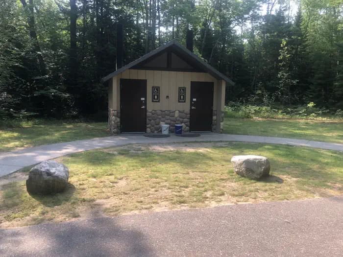
Overview Located just off the Whitefish Bay Scenic Byway in Michigan's Upper Peninsula, Bay View Campground provides a rustic opportunity to camp along the shores of Lake Superior. The campground is a perfect stop amidst many recreational opportunities available in the Sault Ste. Marie area. Visitors also enjoy exploring the Whitefish Bay National Scenic Byway all the way to the beautiful Tahquamenon Falls. Recreation Miles of sandy beaches and beautiful sunsets stretch across Lake Superior, the greatest single body of fresh water in the world. Birding and sightseeing are popular pastimes, and visitors enjoy long walks along Superior's beaches. Facilities Miles of sandy beaches and beautiful sunsets stretch across Lake Superior, the greatest single body of fresh water in the world. Birding and sightseeing are popular pastimes, and visitors enjoy long walks along Superior's beaches. Natural Features The campground is located in Lake Superior's famous Whitefish Bay, the site of numerous historically preserved shipwrecks and lighthouse stations. The area is also a natural corridor for migratory birds. Nearby Attractions Tahquamenon Falls, a series of beautifully brown-colored waterfalls on the Tahquamenon River, are located just 30 miles away. The Great Lakes Shipwreck Museum and Whitefish Point Lighthouse are 39 miles to the north and west while the Point Iroquois Lighthouse lies about 8 miles east. contact_info For facility specific information, please call (906) 373-2272. Charges & Cancellations Please cancel 7 days in advance if you need to cancel your reservation. Reserve sites cannot be transferred to walk up sites.
View details →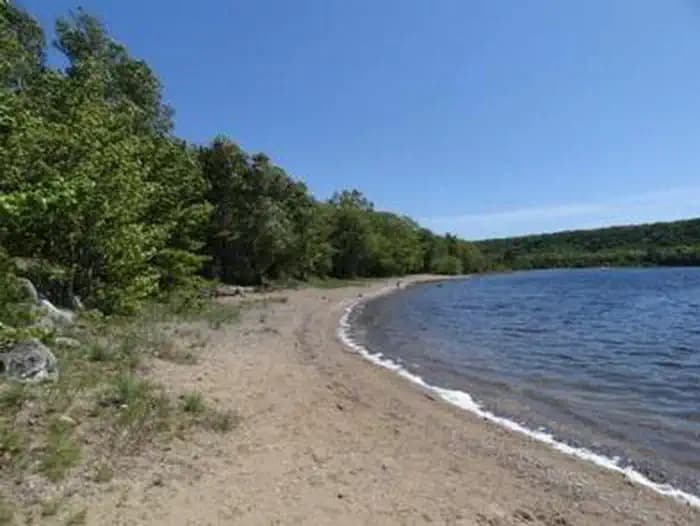
Overview Monocle Lake Campground offers a a relaxing place to fish, swim and hike along the shores of scenic Monocle Lake just off Lake Superior. It is located in Michigan's Upper Peninsula in the northeastern corner of the Hiawatha National Forest. The campground is centrally located among many recreational opportunities in the Sault Ste. Marie area, including the Whitefish Bay National Scenic Byway and Tahquamenon Falls. Recreation Monocle Lake is populated with walleye, smallmouth bass, pike and perch. Two man-made reefs lie just off the eastern shore next to the campground, where anglers typically have good luck. Swimming and boating are popular activities in the area. Visitors also enjoy hiking the 14.5-mile Monocle Lake Trail. Two miles of the trail have interpretive displays, and the first 1100 feet of the trail are along an elevated, accessible boardwalk. Additional trails are found in the surrounding area. Facilities Monocle Lake is populated with walleye, smallmouth bass, pike and perch. Two man-made reefs lie just off the eastern shore next to the campground, where anglers typically have good luck. Swimming and boating are popular activities in the area. Visitors also enjoy hiking the 14.5-mile Monocle Lake Trail. Two miles of the trail have interpretive displays, and the first 1100 feet of the trail are along an elevated, accessible boardwalk. Additional trails are found in the surrounding area. Natural Features The campground surrounds the south end of 172-acre Monocle Lake, and is less than two miles from the historic Point Iroquois Lighthouse. It is nestled in a mixed hardwood forest of aspen, maple, birch and pine trees, providing scenic lake and forest views from anywhere in the campground. Private residences also surround the inland lake. Nearby Attractions The nearest town is Bay Mills, which is about 6 miles from Monocle Lake. The United States-Canada border, at Sault Ste. Marie, is about 25 miles from the campground. Tahquamenon Falls, a series of beautifully brown-colored waterfalls on the Tahquamenon River, is located about 35 miles from Monocle Lake. contact_info For facility specific information, please call (906) 373-2272. Charges & Cancellations Please cancel 7 days in advance if you need to cancel your reservation. Reservation sites cannot be traded for walk-in sites.
View details →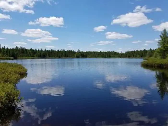
Overview Three Lakes Campground is a peaceful facility tucked away from the busy highway. It is nestled between Whitmarsh, Brown and Walker Lakes, giving visitors ample opportunity to enjoy and explore nature at its best. Recreation The three lakes are open to non-motorized boating. A carry-down boat ramp is located at the campground's picnic area. Fishing is a popular activity. Rainbow trout, perch and catfish are found in the lakes. Although there is no designated swimming beach, sandy areas are located along the shores of the three lakes. Hikers enjoy the serene atmosphere of the campground. The Walker Loop Trail begins within the campground, near the picnic area, and leads hikers around the perimeter of Walker Lake. The trail is easy hiking and traverses about 1.15 miles. Facilities The three lakes are open to non-motorized boating. A carry-down boat ramp is located at the campground's picnic area. Fishing is a popular activity. Rainbow trout, perch and catfish are found in the lakes. Although there is no designated swimming beach, sandy areas are located along the shores of the three lakes. Hikers enjoy the serene atmosphere of the campground. The Walker Loop Trail begins within the campground, near the picnic area, and leads hikers around the perimeter of Walker Lake. The trail is easy hiking and traverses about 1.15 miles. Natural Features The campground is set among a variety of pine, spruce and maple trees on land sandwiched between Lake Superior and Lake Michigan. Whitmarsh, Brown and Walker Lakes dot the landscape to the north, south, and west of the campground. Nearby Attractions The nearest town is Strongs, just 2.5 miles from the campground.
View details →
Overview Widewaters Campground is remotely located on Michigan's upper peninsula in the Hiawatha National Forest. It sits on a stretch of heavily forested land between Lake Superior and Lake Michigan, near a series of smaller lakes and the Indian River, making it an ideal getaway for anglers and explorers alike. Recreation This small, quiet campground is perfect for fishing, canoeing and kayaking. Anglers enjoy catching brook trout in the area. The 9-mile Bruno's Run Trail, which winds its way past a host of small lakes in the area, passes directly through the campground and is a popular trail for hiking and biking, as well as snowshoeing and cross-country skiing in the winter. Facilities This small, quiet campground is perfect for fishing, canoeing and kayaking. Anglers enjoy catching brook trout in the area. The 9-mile Bruno's Run Trail, which winds its way past a host of small lakes in the area, passes directly through the campground and is a popular trail for hiking and biking, as well as snowshoeing and cross-country skiing in the winter. Natural Features Widewaters is in a beautiful forest of mature hardwoods, sandwiched between Irwin Lake and Indian River.
View details →
Overview The Hungerford Recreation Area offers access to over 50 miles of trails for horseback riding, hiking and mountain biking. The horse trails connect to the group campsite. There are a few small lakes located nearby, including, Hungerford Lake, Toogood Lake and Mud Lake. Recreation Forty-seven plus miles of horseback riding trails and 10 miles of mountain biking trails make the campground an ideal place for both equestrian campers and outdoors enthusiasts. Hungerford Lake is located a half mile south of the Hungerford Family Campground and one and a quarter miles south of the Hungerford Equestrian Group Campsite. The area offers fishing and boating opportunities. Horses are not allowed in or around the lake area, but visitors interested in fishing are welcome to cast for bass, pike and pan fish. There is a boat ramp located at the lake. Facilities Forty-seven plus miles of horseback riding trails and 10 miles of mountain biking trails make the campground an ideal place for both equestrian campers and outdoors enthusiasts. Hungerford Lake is located a half mile south of the Hungerford Family Campground and one and a quarter miles south of the Hungerford Equestrian Group Campsite. The area offers fishing and boating opportunities. Horses are not allowed in or around the lake area, but visitors interested in fishing are welcome to cast for bass, pike and pan fish. There is a boat ramp located at the lake. Natural Features The campground is perched along lightly rolling hills in the Manistee National Forest. It is about a mile north of Hungerford Lake and the 48 site Hungerford Campground. The lake spans 30 acres and is a favorite spot to see fall colors. The Manistee National Forest comprises 540,000 acres and meets the eastern shore of Lake Michigan. Nearby Attractions Visit the city of Big Rapids, Michigan, or the Loda Lake Wildflower Sanctuary. Benton, Indian, Brush, and Shelley lakes are also nearby. Charges & Cancellations Cancellations will not be accepted within 7 days of scheduled date of arrival.
View details →
Overview South Branch Trail Campground Group Site is ideal for equestrian camping. The group area impresses with its beautiful scenery and convenient access to horseback riding and hiking along the 240-mile Michigan Shore-to-Shore Horseback Riding and Hiking Trail. Priority will be given to campers with horses, however everyone is welcome. The spacious site holds up to 250 campers and features a day-use horse parking area. Recreation Hike or horseback ride on the Michigan Shore-To-Shore Riding and Hiking Trail. The trail begins in the town of Empire near Lake Michigan, on the west side of Michigan and ends near Oscoda, Michigan on the Lake Huron eastern side of the state. The eastern part of the trail follows the historic AuSable River to its end in AuSable, just south of Oscoda. Facilities Hike or horseback ride on the Michigan Shore-To-Shore Riding and Hiking Trail. The trail begins in the town of Empire near Lake Michigan, on the west side of Michigan and ends near Oscoda, Michigan on the Lake Huron eastern side of the state. The eastern part of the trail follows the historic AuSable River to its end in AuSable, just south of Oscoda. Natural Features Campsites are situated in a stand of oak and pine at an elevation of 880 feet. The campground is adjacent to the South Branch River and is also not too far from the AuSable River. The magnificent Lake Huron is only a short drive east of the campground.
View details →
Overview Round Lake Campground offers a scenic, rustic, wooded camping area offering a wide variety of recreation opportunities in the Huron-Manistee National Forest in Michigan. Recreation There is a wide variety of recreational opportunities located in and around the campground. Anglers can fish for sunfish, bass and pike while campers can relax at the sandy beach. The campground has a gravel boat ramp. Facilities There is a wide variety of recreational opportunities located in and around the campground. Anglers can fish for sunfish, bass and pike while campers can relax at the sandy beach. The campground has a gravel boat ramp. Natural Features Round Lake's 91-acres is mostly surrounded by private land. Round Lake Campground provides the only public access to the lake. Nearby Sand Lake Picnic and Swimming Area are located on the 248-acre Sand Lake. The beach and picnic area provide the only public access to Sand Lake. Nearby Attractions The campground is located in the village of Sand Lake, MI and groceries and fuel are nearby. Lumberman's Monument Visitor's Center is less than 15 miles from the campground. There are hiking trails nearby, a picnic day use area on nearby Sand Lake, bird watching, and hunting opportunities.
View details →
Overview Pictured Rocks National Lakeshore hugs the Lake Superior shoreline for more than 40 miles (64 km) along Michigan's northern coast. Lake Superior is the largest, deepest, coldest, and most pristine of all the Great Lakes. Camping at Pictured Rocks National Lakeshore is a great way to relax and enjoy the beauties the lakeshore has to offer. Campgrounds are rustic, and do not provide electric or sewer hookups. Campers, trailers, and RVs are welcome, note there are generator free areas. Cell phone reception is limited, so unplug, unwind, and enjoy the serenity Pictured Rocks National Lakeshore Campgrounds has to offer. This small campground (8 sites) is located 3 miles (1 km) north of Alger County Road H-58 and 20 miles northeast of Munising on Little Beaver Lake. One campsite is wheelchair accessible. Because of the small campsites and the narrow, twisting, hilly access road it is highly suggested you check the campsite length, width, and height before booking. Pets are NOT allowed at Little Beaver Campground. A small boat ramp is available for launching boats. Only electric motors are permitted on Little Beaver Lake and Beaver Lake as these lakes are within the Beaver Basin Wilderness area. Little Beaver also features the Little Beaver Nature Trail, a 1.0 mile (.3 km) loop trail. A 1.5 mile (2.4 km) trail leads to Lake Superior and connects with the North Country Trail. Recreation Hiking, fishing, boating using electric motor boats, and paddling are popular activities that can be done right from the campground. Facilities Hiking, fishing, boating using electric motor boats, and paddling are popular activities that can be done right from the campground. Natural Features Sandstone cliffs, beaches, sand dunes, waterfalls, inland lakes, deep forest, and wild shoreline beckon you to visit Pictured Rocks National Lakeshore. The power of Lake Superior shapes the park's coastal features and affects every ecosystem, creating a unique landscape to explore. Hiking, camping, sightseeing, and four-season outdoor opportunities abound Nearby Attractions Guided kayaking and other boat tours within the national lakeshore are offered by authorized private companies. Pontoon boat and other rentals for use on Lake Superior are available in nearby communities. Charges & Cancellations
View details →
Overview Twelvemile Beach Campground is a beautiful campground along Lake Superior located within the Pictured Rocks National Lakeshore, just 15 miles (24 km) west of Grand Marais. There are 36 sites total, including 2 universally accessible sites. Twelvemile Beach has water, pit toilets, picnic tables, fire rings, and an interpretive amphitheater. The campground has access to the North Country Trail and the two mile (3.2 km) long self-guided White Birch Interpretive Trail. The turning radius and some of the parking at sites are limited, so the Park recommends that camper, or vehicle/trailer length should NOT exceed 42 feet (13 m). Recreation There are three sets of stairs to the beach as well as a day-use picnic area and parking. The two-mile (3.2 km) long White Birch Trail begins and ends at the campground. The North Country Trail treks through the campground. The entrance road winds through a picturesque stand of white birch. Facilities There are three sets of stairs to the beach as well as a day-use picnic area and parking. The two-mile (3.2 km) long White Birch Trail begins and ends at the campground. The North Country Trail treks through the campground. The entrance road winds through a picturesque stand of white birch. Natural Features Sandstone cliffs, beaches, sand dunes, waterfalls, inland lakes, deep forest, and wild shoreline beckon you to visit Pictured Rocks National Lakeshore. The power of Lake Superior shapes the park's coastal features and affects every ecosystem, creating a unique landscape to explore. Hiking, camping, sightseeing, and four-season outdoor opportunities abound. Nearby Attractions Kayak and Other Guided Tours and Pictured Rocks Boat Cruises within the national lakeshore are offered by authorized private companies. Pontoon boat and other rentals for use on Lake Superior are available in nearby communities. Charges & Cancellations
View details →
Overview Pictured Rocks National Lakeshore hugs the Lake Superior shoreline for more than 40 miles along Michigan's northern coast. Lake Superior is the largest, deepest, coldest, and most pristine of all the Great Lakes. Camping at Pictured Rocks National Lakeshore is a great way to relax and enjoy the beauties the lakeshore has to offer. Campgrounds are rustic, and do not provide electric or sewer hookups. Campers, trailers, and RVs are welcome, note there are generator free areas. Cell phone reception is limited, so unplug, unwind, and enjoy the serenity Pictured Rocks National Lakeshore Campgrounds has to offer. Hurricane River Campground is located 12 miles (19 km) west of Grand Marais and is divided into two separate sections off County Highway (H-) 58, Hurricane River Upper, and Hurricane River Lower. The Upper Campground has 10 sites and the Lower Campground has 12. Campground amenities include water, pit toilets, picnic tables, fire rings, and handicap accessible sites. Hurricane River Lower Campground is the trailhead for the Au Sable Light Station, which is a 3-mile (5 km) round trip stroll to the lighthouse with views of Lake Superior, Jacobsville Sandstone, and Shipwreck remains. Upper Hurricane River is tucked back in the woods with beautiful deciduous trees between sites allowing for the woodsy experience of Northern Michigan. Recreation Pictured Rocks National Lakeshore offers 100 miles (161 km) of hiking trails leading to waterfalls, beaches, forest wilderness, cultural sites, and breathtaking cliff-top views of Lake Superior. Whether you have only a few minutes, hours, or days to see a portion of the lakeshore, one of these hikes may be for you. Lake Superior's rugged shoreline invites boaters to explore the beautiful Pictured Rocks National Lakeshore with its miles of colorful sandstone cliffs and long stretches of sandy beaches. Peaceful inland lakes also invite boaters to linger in the northwoods. Check the marine weather forecast before venturing out. Watch the weather carefully while on the lake. The weather can change suddenly and unexpectedly. Just because it's calm in Munising Bay or Grand Marais Harbor does not mean it is calm along the more distant shores. The Pictured Rocks cliffs rise 50 to 200 feet (15 to 61 m) directly from the lake, offering precious few protected places if the wind and waves increase. Facilities Pictured Rocks National Lakeshore offers 100 miles (161 km) of hiking trails leading to waterfalls, beaches, forest wilderness, cultural sites, and breathtaking cliff-top views of Lake Superior. Whether you have only a few minutes, hours, or days to see a portion of the lakeshore, one of these hikes may be for you. Lake Superior's rugged shoreline invites boaters to explore the beautiful Pictured Rocks National Lakeshore with its miles of colorful sandstone cliffs and long stretches of sandy beaches. Peaceful inland lakes also invite boaters to linger in the northwoods. Check the marine weather forecast before venturing out. Watch the weather carefully while on the lake. The weather can change suddenly and unexpectedly. Just because it's calm in Munising Bay or Grand Marais Harbor does not mean it is calm along the more distant shores. The Pictured Rocks cliffs rise 50 to 200 feet (15 to 61 m) directly from the lake, offering precious few protected places if the wind and waves increase. Natural Features Sandstone cliffs, beaches, sand dunes, waterfalls, inland lakes, deep forest, and wild shoreline beckon you to visit Pictured Rocks National Lakeshore. The power of Lake Superior shapes the park's coastal features and affects every ecosystem, creating a unique landscape to explore. Hiking, camping, sightseeing, and four-season outdoor opportunities abound. Nearby Attractions Kayak and Other Guided Tours and Pictured Rocks Boat Cruises within the national lakeshore are offered by authorized private companies. Pontoon boat and other rentals for use on Lake Superior are available in nearby communities. Charges & Cancellations
View details →
Overview Seaton Creek Campground adjoins Seaton Creek and is at the upper end of the backwater of Hodenpyl Dam Pond on the Big Manistee River. The forest surrounding the campground is mostly pine and the sites are rustic. The closest town is Mesick. Recreation The surrounding waters offer excellent fishing opportunities for both panfish (perch, bluegil, crappie, sunfish) and game fish (trout, bass, pike, salmon). For State Fishing Regulations consult the Michigan Department of Natural Resources website, website http://www.michigan.gov/dnr/ . Kayakers may access the campground by traveling up the very shallow Seaton Creek, however canoeing is not recommended unless you're putting in at the Hodenpyl Backwaters. From there, you can canoe the Big Manistee. There is a connector trail to the Manistee River Trail from this site. The North Country National Scenic Trail can be reached by crossing the suspension bridge over the Manistee River. The Upper Branch Trailhead is also nearby. Facilities The surrounding waters offer excellent fishing opportunities for both panfish (perch, bluegil, crappie, sunfish) and game fish (trout, bass, pike, salmon). For State Fishing Regulations consult the Michigan Department of Natural Resources website, website http://www.michigan.gov/dnr/ . Kayakers may access the campground by traveling up the very shallow Seaton Creek, however canoeing is not recommended unless you're putting in at the Hodenpyl Backwaters. From there, you can canoe the Big Manistee. There is a connector trail to the Manistee River Trail from this site. The North Country National Scenic Trail can be reached by crossing the suspension bridge over the Manistee River. The Upper Branch Trailhead is also nearby. Natural Features The terrain surrounding Hodenpyl Dam Pond is characterized as hilly with a mix of hardwoods and conifers. Briar Hill, which has the second-highest elevation in the lower peninsula, is located about five miles east of Hodenpyl Dam Pond. A number of other tributaries enter Hodenpyl Dam Pond from the east, flowing off the slopes of Briar Hill. These streams are characterized by very high gradient and cold temperatures. They include Seaton Creek, Small Creek, Preston Creek, Cripple Creek, and several unnamed streams. These streams mostly host a mix of brown and brook trout, although a few have only brook trout. The trailhead for the Manistee River Trail is within the campground.
View details →
Overview Island Lake Campground is a small and quiet campground nestled in a mostly pine forest. Island Lake offers great fishing for anglers with small boats or canoes. Recreation Island Lake offers excellent fishing and canoeing or kayaking. Anglers fish for largemouth bass, blue gill and perch. The campground offers fishing from shore. Island Lake Campground features a boat slip for small carry-in boats or canoes. Other popular activities include hiking, biking and ATV trails. Facilities Island Lake offers excellent fishing and canoeing or kayaking. Anglers fish for largemouth bass, blue gill and perch. The campground offers fishing from shore. Island Lake Campground features a boat slip for small carry-in boats or canoes. Other popular activities include hiking, biking and ATV trails. Natural Features Although there are a few mixed hardwood trees in the area, this campground is favored by those individuals who like to camp in a classic pine forest setting. Nearby Attractions There are many waterfalls to see in the area, as well as the popular Pictured Rocks National Lakeshore and Grand Island, located just 15 miles away at Lake Superior.
View details →
Overview Located on the south side of Nichols Lake, the campground and surrounding area offer excellent opportunities for fishing, swimming, picnicking, hiking, camping, or just relaxing. Recreation Fishing and boating are popular activities at Nichols Lake. There is a paved boat launch at the campground. This site is one of the locations on the National Forest's for Kids Fishing Day Events for Michigan's Free Fishing Day in early June. Ice fishing is also popular in the winter. Swimming areas are marked with buoys, but there are no lifeguards. The North Country National Scenic Trail goes through the site near the boat ramp, providing good hiking opportunities. Facilities Fishing and boating are popular activities at Nichols Lake. There is a paved boat launch at the campground. This site is one of the locations on the National Forest's for Kids Fishing Day Events for Michigan's Free Fishing Day in early June. Ice fishing is also popular in the winter. Swimming areas are marked with buoys, but there are no lifeguards. The North Country National Scenic Trail goes through the site near the boat ramp, providing good hiking opportunities. Natural Features At 160 acres, Nichols Lake offers shore, pier, and boat fishing. Typical fish species available include bass, bluegill, pumpkinseed, black crappie, and northern pike. There is a swimming beach and accessible fishing pier available. Those wishing to enjoy the day at Nichols Lake will find a day use area located on the north side of the lake. Nearby Attractions The North Country Trail covers 4,600 miles from Crown Point, NY, to Lake Sakakawea State Park, ND. The segment that includes Nichols Lake has beautiful sections for both the advanced and weekend hikers. The nearest towns are Woodland, Bitely, and Brohman, about two miles to the south.
View details →
Overview D.H. Day Campground is located in the northern district of Sleeping Bear Dunes National Lakeshore, on the lower peninsula of Michigan. This rustic campground is one of the most popular in Northern Michigan and is open (weather permitting) from April 27 through the last Sunday in November. Reservations are required May 1 through October 15. Campsites are within walking distance of the Lake Michigan shoreline and a short drive to many popular features in the park. Summer temperatures range from the upper 70s to 90 degrees F (25° to 32° C) during the day, and from the 50s to 70 degrees F (10° to 25° C) at night. Recreation Sleeping Bear Dunes National Lakeshore's rustic D.H. Day Campground is beautifully wooded. Campers can swim, canoe, kayak, fish and relax along the shoreline of the campground. The multi-use Sleeping Bear Heritage Trail passes through the campground opening up 20+ miles (32 km) of biking and hiking. There are canoe and bicycle rentals nearby in the village of Glen Arbor. The historic village of Glen Haven is a short 15-minute walk away. Multiple hiking trails, the Dune Climb, and the Pierce Stocking Scenic Drive are just a short drive away. D.H. Day Campground is the perfect launching point for a fun-filled stay at Sleeping Bear Dunes National Lakeshore. Facilities Sleeping Bear Dunes National Lakeshore's rustic D.H. Day Campground is beautifully wooded. Campers can swim, canoe, kayak, fish and relax along the shoreline of the campground. The multi-use Sleeping Bear Heritage Trail passes through the campground opening up 20+ miles (32 km) of biking and hiking. There are canoe and bicycle rentals nearby in the village of Glen Arbor. The historic village of Glen Haven is a short 15-minute walk away. Multiple hiking trails, the Dune Climb, and the Pierce Stocking Scenic Drive are just a short drive away. D.H. Day Campground is the perfect launching point for a fun-filled stay at Sleeping Bear Dunes National Lakeshore. Natural Features D.H. Day Campground lies in the middle of Sleeping Bear Dunes National Lakeshore near the historic village of Glen Haven. The spacious wooded campsites are no more than a 5-minute walk to the Lake Michigan beach. Features include northern hardwood and conifer forests, old farm meadows, wetlands, lakes, streams, bogs, and splendid examples of glacially formed landscapes. The beautiful, perched sand dunes, for which the parked is named, are just a few minutes' drive from the campground. Nearby Attractions Village of Glen Arbor (1.5 miles East). The Alligator Hill Trail is less than a mile away. To the West visitors will find the Historic Village of Glen Haven & the General Store bookstore (0.8 miles ), the Maritime Museum (1.1 miles), and the Sleeping Bear Point Trail (1.4 miles). The Dune Climb (2 miles) and Dune Center bookstore are a short drive to the south. 4.2 miles to the south is the Pierce Stocking Scenic Drive, where the Lake Michigan Overlook is located . Village of Empire (7.5 miles South). The Crystal River winds its way to Lake Michigan just a few short miles to the north. The Port Onieda Historic District can be found 5.7 miles to the North. The Harbor Town of Leland is 20 miles north of the Lakeshore & is the gateway to both North and South Manitou Islands . contact_info For local information, please call (231) 326-4700 or call (877) 444-6777 for general information. Charges & Cancellations
View details →
Overview Chimney Loop Campground is located on the shores of Wagner Lake. Wagner Lake is a shallow sandy bottom lake that is entirely surrounded by National Forest. The lake has excellent bass and pan fish fishing. Chimney Loop campground can accommodate groups of up to 30 people and six cars. Recreation Water Activities: Wagner Lake provides visitors opportunites for swimming and beach play. Non-motorized watercraft such as canoes and kayaks can be carried into Wagner Lake. Anglers can try their luck from shore, wadding, or by boat to catch bass and pan fish. Facilities Water Activities: Wagner Lake provides visitors opportunites for swimming and beach play. Non-motorized watercraft such as canoes and kayaks can be carried into Wagner Lake. Anglers can try their luck from shore, wadding, or by boat to catch bass and pan fish. Natural Features The Chimeny Loop group site is set in a forest of oak and pine trees. A very short walk from the shores of Wagner Lake makes this the perfect destination for visitors looking for some solitude. Chimney Loop Campground is located just a short drive from the AuSable River and is close to ORV trails. Charges & Cancellations All reservation changes, cancellations, and refunds are managed through Recreation.gov.
View details →
Overview Planning a trip to the Black River Harbor Campground? Watch for Alerts at the top of the page for any Alerts regarding this facility. Black River Campground is adjacent to the Black River Harbor Recreation Area. The recreation area includes a pavilion, harbor and a large picnic area. The area provides for many opportunities for fishing, boating, backpacking, hiking, bird watching, photography and beautiful scenery for relaxation in the outdoors. Recreation The campground is adjacent to the Black River Harbor Recreation Area. The Harbor offers one of the area's few access points to Lake Superior, with boating and fishing being a major summer time activity. Fishing charters are available at the harbor dock area. The boat ramp can accommodate almost any craft trailered in. Parking for trucks and boat trailers is ample. The area has many trails that follow the Black River leading you to the many waterfalls along the river. The recreation area has a large grassy area for picnics. Facilities The campground is adjacent to the Black River Harbor Recreation Area. The Harbor offers one of the area's few access points to Lake Superior, with boating and fishing being a major summer time activity. Fishing charters are available at the harbor dock area. The boat ramp can accommodate almost any craft trailered in. Parking for trucks and boat trailers is ample. The area has many trails that follow the Black River leading you to the many waterfalls along the river. The recreation area has a large grassy area for picnics. Natural Features Known for its spectacular waterfalls, idyllic beaches, scenic hiking trails and tranquil campground, the Black River Harbor Recreation Area is a popular destination throughout the year. Originating in Wisconsin, the Black River flows through forested areas of large pine, hemlock and hardwood trees. The River has a series of scenic waterfalls as it drops in elevation to meet Lake Superior. Tannin (tannic acids) from hemlock trees is what gives it its unique color. Nearby Attractions A historic pavilion built by the Civilian Conservation Corps is located in the recreation area next to the campground. The recreation area includes a large picnic area and Black River Harbor that has fishing charters available and in itself is a scenic area to explore. Trails run adjacent to the Black River and lead to several waterfalls. A foot bridge and short walk will take you across the Black River to Lake Superior and the sand beach swimming areas. Charges & Cancellations Cancellations If you cancel reservation at least 2 days prior to check in date, all recreation fees, minus a $10 cancellation fee and the reservation fee ($8 if made online or $9 if made through the call center) will be refunded. If you cancel reservation the day before or the day of check in date, all recreation fees, minus $10 cancellation fee, the reservation fee ($8 if made online or $9 if made through the call center), and the first night’s use fee will be refunded. Cancellations for one night reservations will forfeit the entire amount paid. The reservation fee ($8 if made online or $9 if made through the call center) is non-refundable. No Show Staff will hold a campsite until check-out time on the day following the arrival date. For more information about rules and reservation policies, visit the Recreaiton.gov Rules and Reservations Policy page .
View details →
Overview Planning a visit to the Clark Lake Pavilion? Watch for Alerts at the top of the page for any Alerts regarding this facility. The Clark Lake Pavilion, located within the Clark Lake day use area, sits in a beautiful north woods setting; at the north end of Clark Lake. The pavilion provides a large indoor gathering area complete with picnic tables, limited seating and a fireplace. The large parking area serves as parking for the pavilion and Clark Lake day use area; there are 46 parking spots, 2 accessible parking spots, and 1 bus/larger vehicle parking spot. Recreation Clark Lake day use area, Clark Lake campground, and the Sylvania Wilderness provide visitors with a multitude of opportunities to enjoy picnicking, paddling, fishing, hiking, swimming, camping and the solitude of wilderness. With more than 30 named lakes, 26 miles of hiking trails, and 50 backcountry campsites on the wilderness landscape there are no shortage of hiking, paddling, and camping opportunities throughout the area. The Clark Lake campground is just a short drive from the pavilion and provides an overnight camping option for those wishing to camp in the area. Facilities Clark Lake day use area, Clark Lake campground, and the Sylvania Wilderness provide visitors with a multitude of opportunities to enjoy picnicking, paddling, fishing, hiking, swimming, camping and the solitude of wilderness. With more than 30 named lakes, 26 miles of hiking trails, and 50 backcountry campsites on the wilderness landscape there are no shortage of hiking, paddling, and camping opportunities throughout the area. The Clark Lake campground is just a short drive from the pavilion and provides an overnight camping option for those wishing to camp in the area. Natural Features The Clark Lake pavilion sits just outside the Sylvania Wilderness boundary at the north end of Clark Lake. Clark Lake is a crystal clear lake with a natural sandy shoreline, providing excellent swimming and outdoor picnic opportunities just a short walk from the pavilion. Sylvania Wilderness encompasses 18,327 acres of primitive lands and is part of the National Wilderness Preservation System. With its untouched, virgin timber still standing tall, Sylvania looks and feels today like it did when it was first discovered. Sylvania Wilderness welcomes the new and returning visitor with towering, ancient trees, the lonesome call of loons and soft pine needles underfoot. A staggering 4,000 acres of this wilderness is covered by water. Nearby Attractions The Wilderness Lakes Trails system encompasses 38 miles of bike and pedestrian trails that traverse Michigan and Wisconsin, as well as encircling Sylvania Wilderness. This trail system provides a multitude of riding and pedestrian opportunities and has something for everyone. The Land O' Lakes cross country ski trails, adjacent to Sylvania Wilderness, offer approximately 6.5 miles of groomed ski trail. Whether you are an expert skier, or a beginner, you're sure to find a favorite trail that lets you enjoy the great outdoors all winter long. The almost one million acres of the Ottawa National Forest are located in the Western Upper Peninsula of Michigan. The forest extends from the south shore of Lake Superior to the Wisconsin border. The area is rich in wildlife viewing opportunities; breathtaking views of rolling hills dotted with lakes, rivers and waterfalls; and spectacular fall colors. Charges & Cancellations Cancellations If you cancel reservation at least 14 days prior to check in date, all recreation fees, minus a $10 cancellation fee and the reservation fee ($8 if made online or $9 if made through the call center) will be refunded. If you cancel reservation less than 14 days prior to check in date, you forfeit the entire total paid. No Show Staff will hold facility until check-in time on the arrival date. For more information about rules and reservation policies, visit the Recreaiton.gov Rules and Reservations Policy page .
View details →
Overview There are many campsites on the Munising and Rapid River/Manistique Ranger Districts of the Hiawatha National Forest. Many are located on inland lakes and are in a rustic forest environment with few to no amenities and no drinking water. This site does not sit next to a lake. The rustic environment offers a wonderfully serene and peaceful setting for your next camping experience. All of these sites are nestled in hardwood trees and pines. Recreation Visitors will be able to enjoy berry picking and fishing at these dispersed campsites. Licenses are required for fishing in Michigan waters. This site is located adjacent to the Fishdam River, which provides a great fishing opportunity for brook trout. This site does NOT offer swimming. However, there is an excellent beach area located at Camp 7 Lake Campground that is only two miles away. Facilities Visitors will be able to enjoy berry picking and fishing at these dispersed campsites. Licenses are required for fishing in Michigan waters. This site is located adjacent to the Fishdam River, which provides a great fishing opportunity for brook trout. This site does NOT offer swimming. However, there is an excellent beach area located at Camp 7 Lake Campground that is only two miles away. Natural Features Once the site of a Civilian Conservation Corps (CCC) camp, Camp Cook offers a campsite that can be reserved singly or as a group. This site is situated on a large grassy opening, which makes it particulary well suited for large gatherings. It is close in proximity to the Fishdam River, which makes it popular among anglers. Nearby Attractions There are a number of horse, bike, and hiking trails within minutes of several of the sites. In a 15 mile area from this campsite, visitors can expect to find: bait shops, general and grocery stores, gas, a pay phone, trailheads, a fishing pier, biking, and kayak/canoe rentals. Groceries, gasoline, fishing and camping supplies, ice and deli are available nine miles Northeast on County Road 437 in the Thunder Lake Area. contact_info For local information, please call (906) 474-6442 or call (906) 387-2512 for general information.
View details →
Overview Planning a trip to the Lake Ottawa Pavilion? Watch for Alerts at the top of the page for any Alerts regarding this facility. The Lake Ottawa Pavilion, located within the Lake Ottawa Recreation Area, sits in a beautiful north woods setting; along the shore of Lake Ottawa. The Civilian Conservation Corps-era pavilion provides a large indoor gathering area complete with picnic tables, limited seating and a fireplace. Recreation Lake Ottawa is a clear lake with a natural sandy bottom, providing excellent swimming opportunities. Just a short walk from the pavilion is the Lake Ottawa campground and trailhead for the Ge Che hiking trail. The Ge Che trail provides approximately nine miles of hiking opportunities; winding through the campground, day use area and surrounding northern hardwood forest. Spend the night in the Lake Ottawa campground. Choose from campsites located along the lakeshore or those nestled in a forest setting. The boat landing has ample parking and provides anglers with access to this fishery. Anglers enjoy fishing for trout, bass, walleye, and pan-fish. Facilities Lake Ottawa is a clear lake with a natural sandy bottom, providing excellent swimming opportunities. Just a short walk from the pavilion is the Lake Ottawa campground and trailhead for the Ge Che hiking trail. The Ge Che trail provides approximately nine miles of hiking opportunities; winding through the campground, day use area and surrounding northern hardwood forest. Spend the night in the Lake Ottawa campground. Choose from campsites located along the lakeshore or those nestled in a forest setting. The boat landing has ample parking and provides anglers with access to this fishery. Anglers enjoy fishing for trout, bass, walleye, and pan-fish. Natural Features Lake Ottawa is almost completely surrounded by National Forest System land, providing a lovely view of the shoreline and forest. Nearby Attractions Lake Ottawa campground offers 32 campsites, paved access roads, pressurized water system, flush toilets, a trailer dump station, and a picnic shelter with two stone fireplaces and original log picnic tables which were constructed by the Civilian Conservation Corps in the late 1930s. Each campsite has natural vegetation providing some privacy from neighboring sites. Located in the general area is Lake Ottawa, Brule Lake, Hagerman Lake, Brule River, Bass Lake, and miles of hiking trails. Lake Ottawa is a deep cold water lake that provides fishermen with a good variety of game fish. There is a boat landing with ample parking to access Lake Ottawa. The Ge Che hiking and ski trail and the Historic Mile Post Zero/Treaty Tree trail provide hiking opportunities through northern hardwood forests. The almost one million acres of the Ottawa National Forest are located in the Western Upper Peninsula of Michigan. The forest extends from the south shore of Lake Superior to the Wisconsin border. The area is rich in wildlife viewing opportunities; breathtaking views of rolling hills dotted with lakes, rivers and waterfalls; and spectacular fall colors. Charges & Cancellations Cancellations If you cancel reservation at least 14 days prior to check in date, all recreation fees, minus a $10 cancellation fee and the reservation fee ($8 if made online or $9 if made through the call center) will be refunded. If you cancel reservation less than 14 days prior to check in date, you forfeit the entire total paid. No Show Staff will hold facility until check-in time on the arrival date. For more information about rules and reservation policies, visit the Recreaiton.gov Rules and Reservations Policy page .
View details →FAQ
Camping in Michigan
How many campgrounds are listed in Michigan?
TheCampVerse currently lists 53 campgrounds in Michigan.
What campground types are most common in Michigan?
The most common campground types are Campground.
How can I compare campgrounds in Michigan?
Use the campground cards and featured links on this page to compare descriptions, amenities, and details before opening each campground profile.
Keep exploring