
Campgrounds in Minnesota
Discover camping among 10,000 lakes and pristine forests in the North Star State
38
Campgrounds listed
100%
With photos
100%
Detailed descriptions
Campground
Top campground type
Highlights
Featured campgrounds in Minnesota
Explore by campground name letter
Jump to A-Z landing hubs for stronger discovery paths beyond Minnesota.
All campgrounds
Showing 38 campgrounds

Overview Deer Lake Campground is located on scenic Cut Foot Sioux Lake, next to Lake Winnibigoshish, in the heart of the Chippewa National Forest. Visitors come to the area for boating, walleye, northern, sunfish, and crappie fishing, and beautiful scenery. Recreation Boating, swimming, and fishing are popular activities on Cut Foot Sioux Lake. A boat ramp is centrally located between the campground's two loops and provides lake access via Biauswah Creek. A large swimming beach is located at the North Deer Loop and a smaller beach is located at South Deer Loop. Boats may be moored offshore. Miles of trails in the area provide great hiking, horseback riding, mountain biking, and birding opportunities. The 26-mile Cut Foot Sioux National RecreationTrail runs through the campground and connects with the Simpson Creek Trail. Off-highway vehicles, including ATVs and UTVs, can be brough to the campground. However, OHVs must be trailered to roads legal for riding outside the campground. OHV use is not permitted on Eagle Nest Road. Cut Foot Sioux Lake is located next to Lake Winnibigoshish, which can be accessed from Cut Foot Sioux. Lake Winnie offers excellent fishing opportunities for walleye, northern, panfish, and muskie. It is one of Minnesota's premier fisheries. Boating and water skiing are popular activities. Facilities Boating, swimming, and fishing are popular activities on Cut Foot Sioux Lake. A boat ramp is centrally located between the campground's two loops and provides lake access via Biauswah Creek. A large swimming beach is located at the North Deer Loop and a smaller beach is located at South Deer Loop. Boats may be moored offshore. Miles of trails in the area provide great hiking, horseback riding, mountain biking, and birding opportunities. The 26-mile Cut Foot Sioux National RecreationTrail runs through the campground and connects with the Simpson Creek Trail. Off-highway vehicles, including ATVs and UTVs, can be brough to the campground. However, OHVs must be trailered to roads legal for riding outside the campground. OHV use is not permitted on Eagle Nest Road. Cut Foot Sioux Lake is located next to Lake Winnibigoshish, which can be accessed from Cut Foot Sioux. Lake Winnie offers excellent fishing opportunities for walleye, northern, panfish, and muskie. It is one of Minnesota's premier fisheries. Boating and water skiing are popular activities. Natural Features Deer Lake Campground is situated on the northwest shore of Cut Foot Sioux Lake and is split into two separate loops. The North Deer Loop is covered by a hardwood forest of maple and oak, with some mature pine trees scattered throughout the site. South Deer Loop is forested with mature red and white pines. Cut Foot Sioux is home to a variety of waterfowl and birds of prey, including loons, osprey, and bald eagles. The much larger Lake Winnibigoshish is accessible by boat and within sight of these two campgrounds. Nearby Attractions Down the road, East Seelye Bay offers a large picnic area, boat landing with dock and a swimming beach.
View details →
Overview Onegume Campground is located on Little Cut Foot Sioux Lake. It is near MN State Highway 46, also known as Avenue of the Pines Scenic Byway, in the heart of the Chippewa National Forest. Visitors come to the area for boating, excellent fishing, and beautiful scenery. Recreation Boating and swimming are popular activities on Little Cut Foot Sioux Lake. Fishing during Minnesota's season opener is historically very good. An accessible fishing dock and fish cleaning station are located on-site. A few boat slips are located at the water's edge. Miles of trails in the area provide great hiking, horseback riding, mountain biking, and birding opportunities. The Simpson Creek Trail and Cut Foot Sioux National Recreation Trail can be accessed in the area. Little Cut Foot Sioux Lake is located next to and provides access to Lake Winnibigoshish. Lake Winnie offers excellent fishing opportunities for walleye, perch, and muskie. It is one of the state's premier fisheries. Boating and water skiing are also popular activities. Facilities Boating and swimming are popular activities on Little Cut Foot Sioux Lake. Fishing during Minnesota's season opener is historically very good. An accessible fishing dock and fish cleaning station are located on-site. A few boat slips are located at the water's edge. Miles of trails in the area provide great hiking, horseback riding, mountain biking, and birding opportunities. The Simpson Creek Trail and Cut Foot Sioux National Recreation Trail can be accessed in the area. Little Cut Foot Sioux Lake is located next to and provides access to Lake Winnibigoshish. Lake Winnie offers excellent fishing opportunities for walleye, perch, and muskie. It is one of the state's premier fisheries. Boating and water skiing are also popular activities. Natural Features The campground is situated between Highway 46 and Little Cut Foot Sioux Lake, on the east side of the road, before the bridge. A scenic forest of birch and red pine trees covers the area, offering shade and privacy between sites. Eleven sites are located on the lakefront. The lake is home to a variety of waterfowl and birds of prey, including loons, osprey and bald eagles. Nearby Attractions The Cut Foot Sioux Visitor Information Center is just north of the campground. A half-mile accessible trail leads to the center, which offers interpretive displays, educational programs, and area information.
View details →
Overview Reservations to all Chippewa National Forest Campgrounds can be made six months in advance. Stony Point is located on beautiful Leech Lake, in the heart of Minnesota's Chippewa National Forest. Visitors enjoy the area for its boating, canoeing, fishing and birding opportunities. Recreation Boating and fishing are very popular activities enjoyed by visitors to the campground. Anglers will find walleye, perch, bass, northern pike and muskie, where every cast has the potential to yield a trophy-sized catch. A boat ramp and dock are located within the campground. Miles of scenic hiking trails meander around Leech Lake, including the Paul Bunyon State Trail, Heartland Trail, Soo Line Trail and North Country National Scenic Trail. Facilities Boating and fishing are very popular activities enjoyed by visitors to the campground. Anglers will find walleye, perch, bass, northern pike and muskie, where every cast has the potential to yield a trophy-sized catch. A boat ramp and dock are located within the campground. Miles of scenic hiking trails meander around Leech Lake, including the Paul Bunyon State Trail, Heartland Trail, Soo Line Trail and North Country National Scenic Trail. Natural Features The campground is situated on the banks of Leech Lake in an open, grassy area, surrounded by an old growth forest of oak, elm, maple and ash trees. Some trees are over 200 years old. Leech Lake is the third-largest lake in Minnesota at more than 112,000 acres, with nearly 200 miles of shoreline. Campers commonly hear the telltale call of loons on the water. Nearby Attractions The very popular tourist town of Walker, Minnesota is located approximately 14 miles west of the campground, with a variety of restaurants, shops and festivals available there throughout the year.
View details →
Overview Echo Lake is located on the west end of the Echo Trail, a remote country road that traverses through the heart of the Western Superior National Forest. This quiet campground, where the sounds of birds and the wind are often heard, is a peaceful alternative to the hustle and bustle of the area's resort scene. A variety of campsites, activities and amenities offer a comfortable stay for RV, trailer and tent campers. Superior National Forest, located in northeastern Minnesota's arrowhead region, is comprised of three million acres. The forest spans 150 miles along the United States-Canada border. Visitors can find recreation opportunities year-round, including travel in the famous Boundary Waters Canoe Area Wilderness. Recreation Echo Lake is a popular fishing spot for walleye, northern pike, panfish, black crappie, white sucker and yellow perch also living in the lake. The surrounding national forest offers a wide variety of recreational opportunities, including hiking in secluded woodlands and canoeing in pristine lakes and rivers. View recreation guides and maps of hiking trails and canoe routes in the national forest. Facilities Echo Lake is a popular fishing spot for walleye, northern pike, panfish, black crappie, white sucker and yellow perch also living in the lake. The surrounding national forest offers a wide variety of recreational opportunities, including hiking in secluded woodlands and canoeing in pristine lakes and rivers. View recreation guides and maps of hiking trails and canoe routes in the national forest. Natural Features This campground is on the south shore of the 1,222-acre Echo Lake and is surrounded by a mix of aspen, balsam, spruce, maple and pine trees, which provide ample shade. Nearby Attractions Possible day trips from the campground include Voyageurs National Park, Crane Lake, Vermillion Falls, Echo Lake Trail (1.5 miles) and Echo Lake Hunters Walking Trail (10 miles). Numerous outdoor recreation opportunities lie within Superior National Forest's 77 lake accesses, 13 fishing piers, 10 swimming beaches and 22 picnic areas. The forest is also home to three scenic byways and the Boundary Waters Canoe Area Wilderness. Additional sites of interest
View details →
Overview Jeanette Lake Campground is a small, single-loop campground on a peninsula reaching out onto the glacier-carved Lake Jeanette in Superior National Forest. Originally built by the Civilian Conservation Corps in the 1930s, this sweet, picturesque campground is well worth the drive. The facility provides sites that are usually accessible to RVs and tent trailers along with tent-only and hike-in sites. Superior National Forest, located in northeastern Minnesota's arrowhead region, is comprised of three million acres. The forest spans 150 miles along the United States-Canada border. Visitors can find recreation opportunities year-round, including travel in the famous Boundary Waters Canoe Area Wilderness. Recreation The winding shoreline and islands make the 638-acre Lake Jeanette a great place to explore in a canoe or kayak. Fishing opportunities include walleye, northern pike and perch. The campground provides access to the Astrid Lake Hiking Trail for those who want to stretch their legs. The surrounding national forest offers a wide variety of recreational opportunities, including hiking in secluded woodlands and canoeing in pristine lakes and rivers. View recreation guides and maps of hiking trails and canoe routes in the national forest. Facilities The winding shoreline and islands make the 638-acre Lake Jeanette a great place to explore in a canoe or kayak. Fishing opportunities include walleye, northern pike and perch. The campground provides access to the Astrid Lake Hiking Trail for those who want to stretch their legs. The surrounding national forest offers a wide variety of recreational opportunities, including hiking in secluded woodlands and canoeing in pristine lakes and rivers. View recreation guides and maps of hiking trails and canoe routes in the national forest. Natural Features Lake Jeanette is not the largest or most isolated lake in the national forest, but it feels like it is both. Created long ago by a massive glacier, this lake is considered by many to be a special location. The campground is wooded with a pleasant mix of hardwoods, pine and spruce providing shade for most sites. The understory of fern, wildflowers and grass is kept under control by mowing, giving the campground a manicured appearance. Glacial "erratics" (massive boulders) left behind by the receding glacier give the campground character and a place for moss to grow. Nearby Attractions Possible day trips from the campground include Voyageurs National Park, Crane Lake and Vermillion Falls. Numerous outdoor recreation opportunities lie within Superior National Forest's 77 lake accesses, 13 fishing piers, 10 swimming beaches and 22 picnic areas. The forest is also home to three scenic byways and the Boundary Waters Canoe Area Wilderness. Additional sites of interest
View details →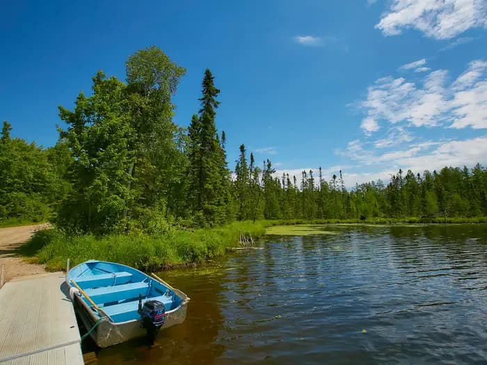
Overview Pfeiffer Lake Campground, located adjacent to it's namesake lake, is a small, peaceful and scenic facility in the Superior National Forest of Minnesota. The lake's healthy population of fish make it a favorite spot for anglers, and the swim beach, playground and picnic area provide fun for the whole family. Superior National Forest, located in northeastern Minnesota's arrowhead region, is comprised of 3 million acres. The forest spans 150 miles along the United States-Canada border. Visitors can find recreation opportunities year-round, including travel in the famous Boundary Waters Canoe Area Wilderness. Recreation Pfeiffer Lake has many activities, fishing being one of the most popular. Panfish, bass, perch and walleye can be caught from the fishing dock or offshore, accessible via the facility's boat ramp. Canoeing and kayaking are also a favorite pastime. The picnic area is next to a grassy swimming beach and 3-mile hiking trail. Facilities Pfeiffer Lake has many activities, fishing being one of the most popular. Panfish, bass, perch and walleye can be caught from the fishing dock or offshore, accessible via the facility's boat ramp. Canoeing and kayaking are also a favorite pastime. The picnic area is next to a grassy swimming beach and 3-mile hiking trail. Natural Features The campground sits in a forest of mixed hardwoods and pine and new pine and cedar have been planted. The lake is 57 acres and has an irregular shoreline great for exploring by canoe or kayak. The lake area is also a nesting place for loons and a habitat for other birds and wildlife. Nearby Attractions Numerous outdoor recreation opportunities lie within Superior National Forest's 77 lake accesses, 13 fishing piers, 10 swimming beaches and 22 picnic areas. The forest is also home to three scenic byways. Additional sites of interest
View details →
Overview Clubhouse Lake Campground is located on its peaceful namesake in the beautiful Chippewa National Forest. Visitors enjoy the area for its fishing and canoeing opportunities in a scenic natural setting. Recreation Clubhouse Lake has excellent water quality and is about 90 feet deep, providing great fishing opportunities for northern pike, bass and panfish. Swimming, canoeing and kayaking are very popular activities on the lake. The Rice River Canoe Route starts its journey to the Big Fork River from waters that flow into Clubhouse Lake. A sandy swimming beach, an accessible fishing pier and a day use area are located within the campground at the water's edge. A kid's fishing day is held at the campground in June, sponsored by the Big Fork Lion's Club and the Forest Service. Facilities Clubhouse Lake has excellent water quality and is about 90 feet deep, providing great fishing opportunities for northern pike, bass and panfish. Swimming, canoeing and kayaking are very popular activities on the lake. The Rice River Canoe Route starts its journey to the Big Fork River from waters that flow into Clubhouse Lake. A sandy swimming beach, an accessible fishing pier and a day use area are located within the campground at the water's edge. A kid's fishing day is held at the campground in June, sponsored by the Big Fork Lion's Club and the Forest Service. Natural Features The campground lies off Highway 38, which is the nation's first National Scenic Byway, known as "The Edge of the Wilderness." A beautiful stand of 200-year-old red and white pine trees cover the campground on the western shore of Clubhouse Lake. Nearby Attractions The Marcell Discovery Center is located a half-mile north of Marcell. It is a must-see for anyone camping in the area. The brand new facility offers many excellent displays, a gift shop and several weekly naturalist programs.
View details →
Overview Chippewa Loop is part of the Norway Beach Recreation Area, on the southern shores of beautiful Cass Lake in north central Minnesota. The campground is a perfect location for family camping, with excellent boating and fishing opportunities. Recreation Cass Lake offers many recreational activities, including boating, canoeing, water skiing and swimming. Anglers fish for walleye, northern pike, perch and trophy muskie. A boat ramp is nearby. Star Island, in the middle of Cass Lake, is a unique feature of the Chippewa National Forest. Six miles of trails wind around the island, which is home to 199-acre Lake Windigo. Hiking and biking trails are available in the area, including the Migizi Bike Trail and the Norway Beach Trail. The Norway Beach Visitor Center is nearby. This building, with its magnificent fireplace, is a monument to the talents and craftsmanship of Civilian Conservation Corps enrollees. Educational programs and displays depict Dakota and Ojibwe heritage and the area's flora and fauna. A variety of special events are held at the center throughout the year. A kid's fishing day is held in June, Bald Eagle Day is sometime in July, and Smokey Bear's birthday party is held in August. Interpretive programs are offered every Wednesday, Friday and Saturday, from Memorial Day through Labor Day. Facilities Cass Lake offers many recreational activities, including boating, canoeing, water skiing and swimming. Anglers fish for walleye, northern pike, perch and trophy muskie. A boat ramp is nearby. Star Island, in the middle of Cass Lake, is a unique feature of the Chippewa National Forest. Six miles of trails wind around the island, which is home to 199-acre Lake Windigo. Hiking and biking trails are available in the area, including the Migizi Bike Trail and the Norway Beach Trail. The Norway Beach Visitor Center is nearby. This building, with its magnificent fireplace, is a monument to the talents and craftsmanship of Civilian Conservation Corps enrollees. Educational programs and displays depict Dakota and Ojibwe heritage and the area's flora and fauna. A variety of special events are held at the center throughout the year. A kid's fishing day is held in June, Bald Eagle Day is sometime in July, and Smokey Bear's birthday party is held in August. Interpretive programs are offered every Wednesday, Friday and Saturday, from Memorial Day through Labor Day. Natural Features The campground is situated on the banks of Cass Lake, in a forest of mature red and white pine trees. Some sites overlook the scenic lake. Cass Lake is the largest of eight lakes that make up the Cass Lake Chain of Lakes. The lake covers nearly 16,000 acres and has 27 miles of forested shoreline and sandy beaches. Nearby Attractions The town of Cass Lake is four miles west of the campground, offering restaurants, a bank, grocery and hardware stores, a movie theater and museum.
View details →
Overview Norway Beach Loop is part of the Norway Beach Recreation Area on the southern shores of beautiful Cass Lake in north central Minnesota. Visitors enjoy the area for its excellent boating and fishing opportunities. Recreation Cass Lake offers many recreational activities, including boating, canoeing, water skiing and swimming. Anglers fish for walleye, Northern pike, perch and trophy muskie, with a boat ramp nearby. Star Island, in the middle of Cass Lake, is a unique feature of the Chippewa National Forest. Six miles of trails wind around the island, which is home to 199-acre Lake Windigo. Hiking and biking trails are available in the area, including the Migizi Bike Trail and the Norway Beach Trail. The Norway Beach Visitor Center is nearby. This building, with its magnificent fireplace, is a monument to the talents and craftsmanship of Civilian Conservation Corps (CCC) enrollees. Programs and displays depict Dakota and Ojibway heritage and the area's flora and fauna. Special annual events are held at the center, including a Kids Fishing Day in June, Bald Eagle Day in July and Smokey Bear's Birthday Party in August. Interpretive programs are offered Wednesdays, Fridays and Saturdays from Memorial Day through Labor Day. Facilities Cass Lake offers many recreational activities, including boating, canoeing, water skiing and swimming. Anglers fish for walleye, Northern pike, perch and trophy muskie, with a boat ramp nearby. Star Island, in the middle of Cass Lake, is a unique feature of the Chippewa National Forest. Six miles of trails wind around the island, which is home to 199-acre Lake Windigo. Hiking and biking trails are available in the area, including the Migizi Bike Trail and the Norway Beach Trail. The Norway Beach Visitor Center is nearby. This building, with its magnificent fireplace, is a monument to the talents and craftsmanship of Civilian Conservation Corps (CCC) enrollees. Programs and displays depict Dakota and Ojibway heritage and the area's flora and fauna. Special annual events are held at the center, including a Kids Fishing Day in June, Bald Eagle Day in July and Smokey Bear's Birthday Party in August. Interpretive programs are offered Wednesdays, Fridays and Saturdays from Memorial Day through Labor Day. Natural Features The campground is situated 500 ft. from the banks of Cass Lake, in a forest of red and white pines. Cass Lake is the largest of eight lakes that make up the Cass Lake Chain of Lakes. The lake covers nearly 16,000 acres and has 27 miles of forested shoreline and sandy beaches. contact_info For facility specific information, please call (218) 835-4291. Nearby Attractions The town of Cass Lake, Minnesota is 4 miles west of the campground, offering restaurants, a bank, grocery and hardware stores, a movie theater and museum.
View details →
Overview Whiteface Reservoir Campground offers an ideal getaway for anglers, boaters and families. The provided swim beach, playground and five picnic areas offer hours of entertainment, and the scenery provides a relaxing backdrop for the day's activities. Superior National Forest, located in northeastern Minnesota's arrowhead region, is comprised of 3 million acres. The forest spans 150 miles along the United States-Canada border. Visitors can find recreation opportunities year-round, including travel in the famous Boundary Waters Canoe Area Wilderness. Recreation A boat launch located at the campground provides access to the great walleye, panfish and northern fishery in the reservoir. The fish cleaning house next to the boat launch gives anglers the chance to clean their fish in time for lunch at the picnic area. Children will have a great time playing on the playground and on the small, sandy beach. There are also 2.5 miles of hiking trails within the facility. Facilities A boat launch located at the campground provides access to the great walleye, panfish and northern fishery in the reservoir. The fish cleaning house next to the boat launch gives anglers the chance to clean their fish in time for lunch at the picnic area. Children will have a great time playing on the playground and on the small, sandy beach. There are also 2.5 miles of hiking trails within the facility. Natural Features Campsites are in a mixed forest including aspen, birch and maple. The reservoir provides 4,980 acres of calm, clean waters. Numerous species of birds and wildlife inhabit the area. contact_info For facility specific information, please call (218) 453-8650. Nearby Attractions There is a store available on-site that provides firewood, bait, bug spray, snacks and other small items. Numerous outdoor recreation opportunities lie within Superior National Forest's 77 lake accesses, 13 fishing piers, 10 swimming beaches and 22 picnic areas. The forest is also home to three scenic byways. Additional sites of interest.
View details →
Overview Cadotte Lake Campground lines the western shore of Cadotte Lake in Superior National Forest. A boat ramp and fishing dock make the campground convenient for anglers, and the sandy swimming beach is popular among families. Superior National Forest, located in northeastern Minnesota's arrowhead region, is comprised of 3 million acres. The forest spans 150 miles along the United States-Canada border. Visitors can find recreation opportunities year-round, including exploring the famous Boundary Waters Canoe Area Wilderness. Recreation The 318-acre Cadotte Lake is a great spot to fish for walleye and northern pike. The surrounding national forest offers a wide variety of recreational opportunities, including hiking in secluded woodlands and canoeing in pristine lakes and rivers. View recreation guides and maps of hiking trails and canoe routes in the national forest. Facilities The 318-acre Cadotte Lake is a great spot to fish for walleye and northern pike. The surrounding national forest offers a wide variety of recreational opportunities, including hiking in secluded woodlands and canoeing in pristine lakes and rivers. View recreation guides and maps of hiking trails and canoe routes in the national forest. Natural Features Superior National Forest is known for its boreal forest ecosystem, numerous clean lakes and diversity of animals and plants. The campground lies in a mixed evergreen, birch and aspen forest. Nearby Attractions Numerous outdoor recreation opportunities lie within Superior National Forest's 77 lake access points, 13 fishing piers, 10 swimming beaches and 22 picnic areas. The forest is also home to three scenic byways.
View details →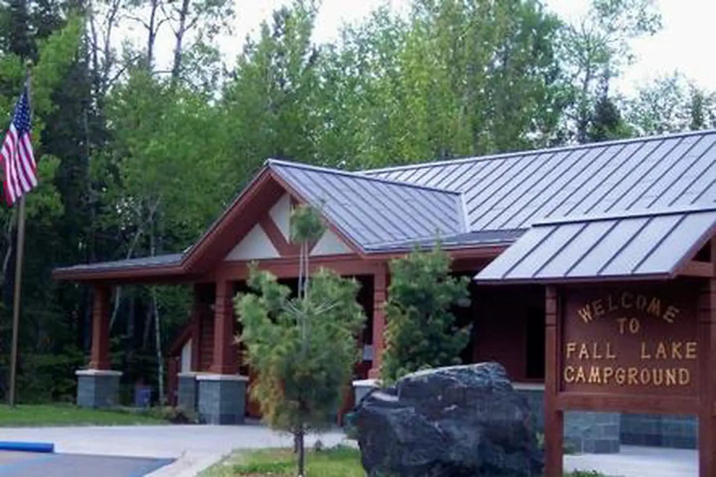
Overview Fall Lake Campground is located on the shores of Fall Lake and provides direct access into the Boundary Waters Canoe Area Wilderness (BWCAW). The campground opens in early May in time for walleye fishing season, making it a popular place for anglers. Others are drawn to Fall Lake for its birding, swimming, hiking and boating opportunities. Superior National Forest, located in northeastern Minnesota's arrowhead region, is comprised of 3 million acres. The forest spans 150 miles along the United States-Canada border. Recreation Part of Fall Lake lies within the BWCAW, while the rest of the lake is open to unrestricted boating, permits are required to enter the BWCAW. View recreation guides and maps of hiking trails and canoe routes in the national forest. Kids love the campground's swimming beach, playground and picnic area. A 1.5 mile hiking trail is also a favorite pastime for families. Anglers can try their luck for smallmouth bass, walleye, northern pike, crappie, perch and bluegill. Some campers might be interested in the unique opportunity to view the visitor center's display of replica artifacts found during archaeological digs within the campground and surrounding areas. There's no shortage of popular local events to attend, including the City of Ely's July 4th fireworks, the Blueberry Festival (the last full weekend in July) and the Harvest Moon Festival-mid September. Facilities Part of Fall Lake lies within the BWCAW, while the rest of the lake is open to unrestricted boating, permits are required to enter the BWCAW. View recreation guides and maps of hiking trails and canoe routes in the national forest. Kids love the campground's swimming beach, playground and picnic area. A 1.5 mile hiking trail is also a favorite pastime for families. Anglers can try their luck for smallmouth bass, walleye, northern pike, crappie, perch and bluegill. Some campers might be interested in the unique opportunity to view the visitor center's display of replica artifacts found during archaeological digs within the campground and surrounding areas. There's no shortage of popular local events to attend, including the City of Ely's July 4th fireworks, the Blueberry Festival (the last full weekend in July) and the Harvest Moon Festival-mid September. Natural Features The campground is nestled among majestic pine and abundant aspen and fir trees, providing the ultimate northwoods setting. Average summer temperatures are a pleasant 60-75 degrees. Birds and wildlife are abundant. Nearby Attractions Guests may want to take a day trip to the Dorothy Molter Museum, International Wolf Center, North American Bear Center, Ely-Winton History Museum or Soudan Mine. By far the most popular nearby attraction is the Boundary Waters Canoe Area Wilderness . Over one million acres in size, the Boundary Waters contain over 1,200 miles of canoe routes, 12 hiking trails and over 2,000 designated campsites.
View details →
Overview Iron Lake Campground is located in a dense forest along the banks of Iron Lake in far northern Minnesota. The campground is unique due to its remoteness and small size. Fishing and canoeing are its biggest draws, as the lake provides access to the Boundary Waters Canoe Area Wilderness. The Ham Lake Fire passed through the campground in 2007. Visitors may be surprised at how the burned area is greening up. Soils and seedling trees are delicate. Some dead trees, which were left standing to provide habitat, may be hazardous. Use caution and stay out of closed areas. Recreation Iron Lake provides many boating opportunities. The campground offers plenty of canoeing and fishing opportunities. Walleye and northern pike fishing are usually good. Canoes, kayaks and small boats must be carried down to access the lake. When portaging or paddling out of this lake and into another, visitors should find out if they will be entering the Boundary Waters Canoe Area Wilderness. Entry requires a permit (self-issued for day use) and visitors must follow wilderness regulations including group size. **View recreation guides and maps of hiking trails and canoe routes in the national forest. View recreation guides and maps of hiking trails and canoe routes in the national forest. Facilities Iron Lake provides many boating opportunities. The campground offers plenty of canoeing and fishing opportunities. Walleye and northern pike fishing are usually good. Canoes, kayaks and small boats must be carried down to access the lake. When portaging or paddling out of this lake and into another, visitors should find out if they will be entering the Boundary Waters Canoe Area Wilderness. Entry requires a permit (self-issued for day use) and visitors must follow wilderness regulations including group size. **View recreation guides and maps of hiking trails and canoe routes in the national forest. View recreation guides and maps of hiking trails and canoe routes in the national forest. Natural Features Iron Lake is in a burn area, and visitors can see post-fire ecology including uncommon black-backed woodpeckers. Moose, bear, loons and other wildlife live in the area. Blueberries grow abundantly in the area and can be picked in mid to late summer. Nearby Attractions The BWCAW is by far the most popular nearby attraction. Over 1 million acres in size, the Boundary Waters extend nearly 150 miles along the United States-Canada border and contains over 1,200 miles of canoe routes, 12 hiking trails and over 2,000 designated campsites. Boundary Waters Canoe Area Wilderness Additional sites of interest contact_info For facility specific information, please call (218) 387-1750.
View details →
Overview Trail's End Campground is located next to the Boundary Waters Canoe Area Wilderness (BWCAW) in a remote area of Superior National Forest in northern Minnesota. It is a wonderful place to sit and enjoy life, or get out on the water to canoe and fish. Berry picking and wildlife viewing are also great fun. Recreation Trail's End includes four entry points (54, 55, J and K) into the BWCAW, offering plenty of boating, canoeing and fishing opportunities. Overnight, day use and boat motor permits are required for entry, and horsepower limits are in effect. Day use and overnight permits are available at the campground. Wildlife viewing is exceptional for bald eagles, osprey, loons and moose, and fishing is good for walleye, northern pike, smallmouth bass and lake trout. View recreation guides and maps of hiking trails and canoe routes in the national forest. Facilities Trail's End includes four entry points (54, 55, J and K) into the BWCAW, offering plenty of boating, canoeing and fishing opportunities. Overnight, day use and boat motor permits are required for entry, and horsepower limits are in effect. Day use and overnight permits are available at the campground. Wildlife viewing is exceptional for bald eagles, osprey, loons and moose, and fishing is good for walleye, northern pike, smallmouth bass and lake trout. View recreation guides and maps of hiking trails and canoe routes in the national forest. Natural Features Trail's End sits along the Seagull River and provides access to Seagull, Gull and Saganaga Lakes. Numerous species of wildlife live in and around the campground, and blueberries grow abundantly on the forest floor. White and red pine, aspen and birch trees grow in the forested parts of the facility, providing shade. The fire burned a mosaic pattern, reducing some areas to ash while leaving others untouched. Many trees survived and burned areas have begun to grow again. This is a great opportunity to see a young forest rejuvenate after a fire. Post-fire soils and young trees are delicate, so caution should be taken while walking in the forest. contact_info For facility specific information, please call (218) 387-1750. Nearby Attractions The nearby Chik-Wauk Museum and Nature Center is a great way to spend an afternoon with the family. Many nature trails crisscross the center's 50-acre grounds. The BWCAW is by far the most popular nearby attraction. Over 1 million acres in size, the Boundary Waters extend nearly 150 miles along the United States-Canada border and contain over 1,200 miles of canoe routes, 12 hiking trails and over 2,000 designated campsites. Boundary Waters Canoe Area Wilderness Additional sites of interest
View details →
Overview Flour Lake Campground provides a convenient home base for exploring the Boundary Waters Canoe Area Wilderness (BWCAW). Its scenery, amenities and access to outdoor recreation areas make it a popular campground for canoeing, kayaking, boating, and fishing. Superior National Forest, located in northeastern Minnesota's Arrowhead Region, is comprised of 3 million acres. The forest spans 150 miles along the United States-Canada border. Visitors can find recreation opportunities year-round, including travel in the famed Boundary Waters. Recreation The eastern edge of Flour Lake has two separate portages for entering the BWCAW, thus this campground attracts canoe and kayak enthusiasts. Portages link Flour Lake with East Bearskin Lake and Moon Lake. Flour Lake also provides great fishing for bass, walleye and lake trout. Entering the BWCAW requires a permit. Day use permits are available at no charge; inquire at the campground host site. View recreation guides and maps of hiking trails and canoe routes in the national forest. The half-mile Honeymoon Bluff Trail begins a short walk up the road from the campground and offers a great vista of Hungry Jack Lake. Many additional hiking, mountain biking and cross-country ski trails are nearby. Facilities The eastern edge of Flour Lake has two separate portages for entering the BWCAW, thus this campground attracts canoe and kayak enthusiasts. Portages link Flour Lake with East Bearskin Lake and Moon Lake. Flour Lake also provides great fishing for bass, walleye and lake trout. Entering the BWCAW requires a permit. Day use permits are available at no charge; inquire at the campground host site. View recreation guides and maps of hiking trails and canoe routes in the national forest. The half-mile Honeymoon Bluff Trail begins a short walk up the road from the campground and offers a great vista of Hungry Jack Lake. Many additional hiking, mountain biking and cross-country ski trails are nearby. Natural Features The campground sits on the quiet shore of 352-acre Flour Lake in a stand of mixed hardwoods and pine. The lake features several shallow bays that are frequented by a variety of wildlife, including moose, beavers, bald eagles, ducks, loons, songbirds and bears. Nearby Attractions Golden Eagle Lodge, the lake concessionaire, offers many other services and conveniences as well as watercraft rental, coin-operated showers and approved firewood. By far, the most popular nearby attraction is the BWCAW, with over 1,200 miles of canoe routes, 12 hiking trails and over 2,000 designated campsites. Boundary Waters Canoe Area Wilderness Additional sites of interest
View details →
Overview Norway Beach Picnic Shelter is part of the Norway Beach Recreation Area on the southern shores of beautiful Cass Lake in north central Minnesota. The shelter and adjacent beach are a wonderful setting for family reunions, company picnics or weddings. Recreation Cass Lake offers many recreational activities, including boating, canoeing, water skiing and swimming. Anglers fish for walleye, Northern pike, perch and trophy muskie. A boat ramp is nearby. Star Island, in the middle of Cass Lake, is a unique feature of the Chippewa National Forest. Six miles of trails wind around the island, which is home to 199-acre Lake Windigo. Hiking and biking trails are available in the area, including the Migizi Bike Trail and the Norway Beach Trail. The Norway Beach Visitor Center is nearby. This building, with its magnificent fireplace, is a monument to the talents and craftsmanship of Civilian Conservation Corps (CCC) enrollees. Programs and displays depict Dakota and Ojibway heritage and the area's flora and fauna. Special annual events are held at the center, including a Kids Fishing Day in June, Bald Eagle Day in July and Smokey Bear's Birthday Party in August. Interpretive programs are offered Wednesdays, Fridays and Saturdays from Memorial Day through Labor Day. Facilities Cass Lake offers many recreational activities, including boating, canoeing, water skiing and swimming. Anglers fish for walleye, Northern pike, perch and trophy muskie. A boat ramp is nearby. Star Island, in the middle of Cass Lake, is a unique feature of the Chippewa National Forest. Six miles of trails wind around the island, which is home to 199-acre Lake Windigo. Hiking and biking trails are available in the area, including the Migizi Bike Trail and the Norway Beach Trail. The Norway Beach Visitor Center is nearby. This building, with its magnificent fireplace, is a monument to the talents and craftsmanship of Civilian Conservation Corps (CCC) enrollees. Programs and displays depict Dakota and Ojibway heritage and the area's flora and fauna. Special annual events are held at the center, including a Kids Fishing Day in June, Bald Eagle Day in July and Smokey Bear's Birthday Party in August. Interpretive programs are offered Wednesdays, Fridays and Saturdays from Memorial Day through Labor Day. Natural Features The shelter is situated on the banks of Cass Lake, at the edge of a forest of red and white pines. A beautiful white sand beach lies in front of the shelter. Cass Lake is the largest of eight lakes that make up the Cass Lake Chain of Lakes. The lake covers nearly 16,000 acres and has 27 miles of forested shoreline and sandy beaches. Nearby Attractions The town of Cass Lake, Minnesota is 4 miles west of the campground, offering restaurants, a bank, grocery and hardware stores, a movie theater and museum.
View details →
Overview South Pike Bay Campground is located on the south shore of beautiful Pike Bay, on Cass Lake in north central Minnesota. Visitors enjoy the area for its excellent boating, canoeing and fishing opportunities. Recreation South Pike Bay offers offers many recreational activities, including boating, canoeing, water skiing and swimming. Anglers fish for walleye, northern pike, perch and trophy muskie. A boat ramp is located within the campground. A trailhead for the Migizi Bike Trail is on-site. The paved trail stretches 14 miles along the lakeshore and is open to biking, walking and rollerblading. The campground is a portage point for the 128-mile Chippewa Headwaters Loop Canoe Route. With six portages, the historic waterway is considered the most difficult in the forest, but is a beautiful trip through history. Facilities South Pike Bay offers offers many recreational activities, including boating, canoeing, water skiing and swimming. Anglers fish for walleye, northern pike, perch and trophy muskie. A boat ramp is located within the campground. A trailhead for the Migizi Bike Trail is on-site. The paved trail stretches 14 miles along the lakeshore and is open to biking, walking and rollerblading. The campground is a portage point for the 128-mile Chippewa Headwaters Loop Canoe Route. With six portages, the historic waterway is considered the most difficult in the forest, but is a beautiful trip through history. Natural Features The campground is a long spur stretching along the shore of Pike Bay in a pleasant stand of mixed hardwoods and old growth pine. Some of the campsites are situated on the beautiful sand beach. Nearby Attractions The town of Cass Lake, Minn., is six miles northwest of the campground, offering restaurants, a bank, grocery and hardware stores, a movie theater and museum.
View details →
Overview Cass Lake Loop is part of the Norway Beach Recreation Area on beautiful Cass Lake in north central Minnesota. Visitors enjoy the area for its excellent boating and fishing opportunities. Recreation Cass Lake offers many recreational activities, including boating, canoeing, water skiing and swimming. Anglers fish for walleye, Northern pike, perch and trophy muskie. A boat ramp is nearby. Star Island, in the middle of Cass Lake, is a unique feature of the Chippewa National Forest. Six miles of trails wind around the island, which is home to 199-acre Lake Windigo. Hiking and biking trails are available in the area, including the Migizi Bike Trail and the Norway Beach Trail. The Norway Beach Visitor Center is nearby. This building, with its magnificent fireplace, is a monument to the talents and craftsmanship of Civilian Conservation Corps (CCC) enrollees. Programs and displays depict Dakota and Ojibway heritage and the area's flora and fauna. Special annual events are held at the center including a Kids Fishing Day in June, Bald Eagle Day in July and Smokey Bear's Birthday Party in August. Interpretive programs are offered Wednesdays, Fridays and Saturdays from Memorial Day through Labor Day. Facilities Cass Lake offers many recreational activities, including boating, canoeing, water skiing and swimming. Anglers fish for walleye, Northern pike, perch and trophy muskie. A boat ramp is nearby. Star Island, in the middle of Cass Lake, is a unique feature of the Chippewa National Forest. Six miles of trails wind around the island, which is home to 199-acre Lake Windigo. Hiking and biking trails are available in the area, including the Migizi Bike Trail and the Norway Beach Trail. The Norway Beach Visitor Center is nearby. This building, with its magnificent fireplace, is a monument to the talents and craftsmanship of Civilian Conservation Corps (CCC) enrollees. Programs and displays depict Dakota and Ojibway heritage and the area's flora and fauna. Special annual events are held at the center including a Kids Fishing Day in June, Bald Eagle Day in July and Smokey Bear's Birthday Party in August. Interpretive programs are offered Wednesdays, Fridays and Saturdays from Memorial Day through Labor Day. Natural Features The campground is located on the banks of Cass Lake, among a scenic forest of mature red and white pine. Cass Lake is the largest of eight lakes that make up the Cass Lake Chain of Lakes. The lake covers nearly 16,000 acres and has 27 miles of forested shoreline and sandy beaches. Nearby Attractions The town of Cass Lake, Minnesota is 4 miles west of the campground, offering restaurants, a bank, grocery and hardware stores, a movie theater and museum.
View details →
Overview Wanaki Loop is part of the Norway Beach Recreation Area, at the southern shores of beautiful Cass Lake in north central Minnesota. The campground is a perfect location for family camping, with excellent boating and fishing opportunities. Recreation Cass Lake offers many recreational activities, including boating, canoeing, water skiing and swimming. Anglers fish for walleye, northern pike, perch and trophy muskie. A boat ramp is located within the campground. Star Island, in the middle of Cass Lake, is a unique feature of the Chippewa National Forest. Six miles of trails wind around the island, which is home to 199-acre Lake Windigo. Hiking and biking trails are available in the area, including the Migizi Bike Trail and the Norway Beach Trail. The Norway Beach Visitor Center is nearby. This building, with its magnificent fireplace, is a monument to the talents and craftsmanship of Civilian Conservation Corps enrollees. Programs and displays depict Dakota and Ojibwe heritage and the area's flora and fauna. A variety of special events are held at the center throughout the year. A kid's fishing day is held in June, Bald Eagle Day is sometime in July, and Smokey Bear's birthday party is held in August. Interpretive programs are offered every Wednesday, Friday and Saturday, from Memorial Day through Labor Day. Facilities Cass Lake offers many recreational activities, including boating, canoeing, water skiing and swimming. Anglers fish for walleye, northern pike, perch and trophy muskie. A boat ramp is located within the campground. Star Island, in the middle of Cass Lake, is a unique feature of the Chippewa National Forest. Six miles of trails wind around the island, which is home to 199-acre Lake Windigo. Hiking and biking trails are available in the area, including the Migizi Bike Trail and the Norway Beach Trail. The Norway Beach Visitor Center is nearby. This building, with its magnificent fireplace, is a monument to the talents and craftsmanship of Civilian Conservation Corps enrollees. Programs and displays depict Dakota and Ojibwe heritage and the area's flora and fauna. A variety of special events are held at the center throughout the year. A kid's fishing day is held in June, Bald Eagle Day is sometime in July, and Smokey Bear's birthday party is held in August. Interpretive programs are offered every Wednesday, Friday and Saturday, from Memorial Day through Labor Day. Natural Features The campground is situated on the banks of Cass Lake, in a forest of mature red and white pine trees. Some sites have lake views and are near the loop's sandy beach. Cass Lake is the largest of eight lakes that make up the Cass Lake Chain of Lakes. The lake covers nearly 16,000 acres and has 27 miles of forested shoreline and sandy beaches. Nearby Attractions The town of Cass Lake is located four miles west of the campground, offering restaurants, a bank, grocery and hardware stores, a movie theater and museum.
View details →
Overview Winnie Campground is remotely located on the west side of Lake Winnibigoshish in the heart of the Chippewa National Forest. Visitors come to the area to enjoy boating, trophy muskie fishing and beautiful scenery. Recreation Lake Winnie offers excellent fishing opportunities for walleye, perch and muskie. It is one of Minnesota's premier fisheries. Boating on this 67,000-acre lake is also very popular. A boat ramp and harbor are located next to the campground. Many hiking and biking trails meander around the lake and its 141 miles of shoreline. A picnic area is adjacent to the campground. Hunting areas can be found in the surrounding forest. Facilities Lake Winnie offers excellent fishing opportunities for walleye, perch and muskie. It is one of Minnesota's premier fisheries. Boating on this 67,000-acre lake is also very popular. A boat ramp and harbor are located next to the campground. Many hiking and biking trails meander around the lake and its 141 miles of shoreline. A picnic area is adjacent to the campground. Hunting areas can be found in the surrounding forest. Natural Features The campground is situated on the western shore of the lake in a scenic forest of mature red and white pine. Some sites have lake views. Nearby Attractions The town of Cass Lake, Minnesota is 25 miles west of the campground, offering restaurants, a bank, grocery and hardware stores, a movie theater and museum.
View details →
Overview Knutson Dam Campground is located on the northeastern shores of Cass Lake and the Mississippi River. Recreation Cass Lake offers many recreational activities, including boating, water skiing and swimming. Anglers fish for walleye, northern pike, perch and trophy muskie. Boat ramps on the lake and river are located within the campground. Canoeists love Knutson Dam's location for its easy canoe access to the Mississippi River. Several canoe routes traverse the area waterways, including the Mississippi. Facilities Cass Lake offers many recreational activities, including boating, water skiing and swimming. Anglers fish for walleye, northern pike, perch and trophy muskie. Boat ramps on the lake and river are located within the campground. Canoeists love Knutson Dam's location for its easy canoe access to the Mississippi River. Several canoe routes traverse the area waterways, including the Mississippi. Natural Features The campground consists of a single loop among beautifully manicured lawns, shaded by a forest of oak, spruce and pine. Every site affords scenic lake views.
View details →
Overview Crescent Lake is an undeveloped lake surrounded entirely by the remote Superior National Forest. This quiet campground has waterfront campsites with easy access to fishing, exploring the nearby wilderness and simply enjoying the beauty of the natural area. Superior National Forest, located in northeastern Minnesota's arrowhead region, is comprised of 3 million acres. The forest spans 150 miles along the United States-Canada border. Visitors can find recreation opportunities year-round, including travel in the famous Boundary Waters Canoe Area Wilderness. Recreation The fishing is good for walleye, northern pike and muskie. Crescent Lake allows motorized boat use without limit on horsepower, but is most appropriate for small fishing or similar type boats. The surrounding national forest offers a wide variety of recreational opportunities, including hiking in secluded woodlands and canoeing in pristine lakes and rivers. View recreation guides and maps of hiking trails and canoe routes in the national forest. Facilities The fishing is good for walleye, northern pike and muskie. Crescent Lake allows motorized boat use without limit on horsepower, but is most appropriate for small fishing or similar type boats. The surrounding national forest offers a wide variety of recreational opportunities, including hiking in secluded woodlands and canoeing in pristine lakes and rivers. View recreation guides and maps of hiking trails and canoe routes in the national forest. Natural Features Superior National Forest is known for its boreal forest ecosystem, numerous clean lakes and diversity of plants and animals. The entire campground is heavily wooded with white pines, red pines, spruce, balsam, birch and aspen. Birds and wildlife are abundant, from moose and bear to bald eagles and loons. Nearby Attractions The concessionaire Sawbill Canoe Outfitters maintains a store with showers, laundry, fishing licenses, fishing bait and tackle, ice, grocery and convenience items, canoe and camping gear rental and a pay telephone. It is 13 miles from the campground. Numerous outdoor recreation opportunities lie within Superior National Forest, including the nearby Boundary Waters Canoe Area Wilderness. Over one million acres in size, the Boundary Waters extend nearly 150 miles along the United States-Canada border and contain over 1,200 miles of canoe routes, 12 hiking trails and over 2,000 designated campsites. Additional sites of interest .
View details →
Overview Sawbill Lake Campground has immediate access to the Boundary Waters Canoe Area Wilderness, a beautiful, peaceful and wild natural feature of Minnesota's Superior National Forest. The campground acts as a convenient base camp for exploring the nearby wilderness. Superior National Forest, located in northeastern Minnesota's Arrowhead Region, is comprised of 3 million acres. The forest spans 150 miles along the United States-Canada border. Visitors can find recreation opportunities year-round, including travel in the famed Boundary Waters. Recreation This facility draws canoe enthusiasts who seek a quiet and convenient area from which to access the surrounding wilderness. Day and overnight use of the Boundary Waters requires a permit. The campground concessionaire, Sawbill Canoe Outfitters, provides a one-stop shop for canoeists of all levels within walking distance of the campground. Canoe rentals, permits and guided canoe trips are available. Campers who wish to spend time relaxing at the campground can fish for northern pike and bass; hike, bike, picnic and attend educational programs. View recreation guides and maps of hiking trails and canoe routes in the national forest. Facilities This facility draws canoe enthusiasts who seek a quiet and convenient area from which to access the surrounding wilderness. Day and overnight use of the Boundary Waters requires a permit. The campground concessionaire, Sawbill Canoe Outfitters, provides a one-stop shop for canoeists of all levels within walking distance of the campground. Canoe rentals, permits and guided canoe trips are available. Campers who wish to spend time relaxing at the campground can fish for northern pike and bass; hike, bike, picnic and attend educational programs. View recreation guides and maps of hiking trails and canoe routes in the national forest. Natural Features Sawbill Lake is nestled in a thick pine forest that gives campsites excellent privacy. Birds and wildlife are abundant, from moose and bear to bald eagles and loons. Wildflowers add bright colors to the landscape in warmer months. The campground sits on a hill above Sawbill Lake. The 765-acre lake is within the Boundary Waters. Nearby Attractions Sawbill Canoe Outfitters maintains a store with showers, laundry, fishing licenses, bait and tackle, ice, grocery and convenience items, canoe and camping gear, rentals and a pay telephone. Over 1 million acres in size, the Boundary Waters Canoe Area Wilderness contains over 1,200 miles of canoe routes, 12 hiking trails and over 2,000 designated campsites. Boundary Waters Canoe Area Wilderness Additional sites of interest
View details →
Overview East Bearskin Lake Campground is located on its namesake lake, at the edge of the Boundary Waters Canoe Area Wilderness in Northern Minnesota. It is a perfect spot for visitors who want the experience found in Boundary Waters and the convenience of car camping. Visitors can reserve standard or walk-in tent sites, or rent small cabins that accommodate up to five or seven people. Canoeing, kayaking and motorized boating is available on East Bearskin Lake. The facility can be conveniently accessed by vehicle. Guests are responsible for their own travel arrangements and safety, and must bring several of their own amenities. Recreation Over a million acres in size, the Boundary Waters Canoe Area Wilderness extends nearly 150 miles along the borders of the United States and Canada, containing over 1,200 miles of canoe routes, 12 hiking trails and over 2,000 designated campsites. The two eastern bays of the lake are within the boundaries of Boundary Waters, thus the campground attracts canoe enthusiasts. Portages link to Flour Lake. Entering the wilderness area requires a special permit. Day permits for non-motorized use are available at the campground, but overnight and motor use permits must be obtained in advance. More information on the Boundary Waters region can be found here . East Bearskin Lake features several shallow bays, making the campground and shoreline good places for wildlife watching. Moose, beavers, eagles, ducks, loons, songbirds and bears are the most common visitors. See recreation guides and maps of hiking trails and canoe routes in the national forest. Fishing is also a huge draw for the area, with East Bearskin Lake offering great fishing for bass, walleye and lake trout. A boat ramp at the campground allows motorboats and canoes access to the lake. Back on shore, a variety of hiking, mountain biking and cross-country ski trails are nearby. Facilities Over a million acres in size, the Boundary Waters Canoe Area Wilderness extends nearly 150 miles along the borders of the United States and Canada, containing over 1,200 miles of canoe routes, 12 hiking trails and over 2,000 designated campsites. The two eastern bays of the lake are within the boundaries of Boundary Waters, thus the campground attracts canoe enthusiasts. Portages link to Flour Lake. Entering the wilderness area requires a special permit. Day permits for non-motorized use are available at the campground, but overnight and motor use permits must be obtained in advance. More information on the Boundary Waters region can be found here . East Bearskin Lake features several shallow bays, making the campground and shoreline good places for wildlife watching. Moose, beavers, eagles, ducks, loons, songbirds and bears are the most common visitors. See recreation guides and maps of hiking trails and canoe routes in the national forest. Fishing is also a huge draw for the area, with East Bearskin Lake offering great fishing for bass, walleye and lake trout. A boat ramp at the campground allows motorboats and canoes access to the lake. Back on shore, a variety of hiking, mountain biking and cross-country ski trails are nearby. Natural Features The campground and surrounding area is shaded with majestic red and white pines, balsam fir, spruce, birch and aspen trees. A thick understory offers plenty of shade and excellent privacy between campsites. The campground lies on the shore of the 643-acre East Bearskin Lake, a typical loon nesting site. The surrounding Superior National Forest is located in northeastern Minnesota's arrowhead region and is comprised of 3 million acres. The forest spans 150 miles along the border of the United States and Canada. Visitors can find recreation opportunities year-round, including travel in the famous Boundary Waters area. Nearby Attractions Boats, canoes and kayaks are available for rent at the neighboring Bearskin Lodge. The store also offers fishing licenses, day use permits, groceries, ice, firewood, maps and fishing guide services for sale.
View details →
Overview In Central Minnesota's popular lakes area, the Cross Lake Recreation Area is best known for its picturesque sunsets, beautiful beaches and well-maintained campsites. The campground provides a full menu of activities for camping enthusiasts, while being located just minutes from shopping and paved bike trails. For a virtual tour go to: http://www.photographyoptions.net/images/headwaters/tour.html Recreation The recreation area provides plenty of water based entertainment like boating, canoeing, kayaking, water skiing and fishing. Two onsite beaches are convenient for swimming and sunbathing. Two accessible fishing piers provide angling opportunities on both Cross Lake and the Pine River. Facilities The recreation area provides plenty of water based entertainment like boating, canoeing, kayaking, water skiing and fishing. Two onsite beaches are convenient for swimming and sunbathing. Two accessible fishing piers provide angling opportunities on both Cross Lake and the Pine River. Natural Features Cross Lake Recreation Area is nestled among tall pines on the eastern banks of Cross Lake on the Whitefish Chain of Lakes. The area has tremendous appeal, with access to 13 natural lakes, 13,660 acres of water and 119 miles of scenic shoreline. The collection of lakes help form the Headwaters of the Mississippi River. Nearby Attractions The Recreation Area is located adjacent to the city of Crosslake and is just a short walk from shopping and a paved bike trail. It's also near the Crow Wing State Park where visitors can view the Mississippi River from the historic "Chippewa Lookout." Charges & Cancellations Reservations must check in within 24 hours of their scheduled arrival or risk their reservation being cancelled. Modifications to existing reservations will be charged a $10.00 non-refundable modification fee. Modifications to reservations may be made online or by calling Recreation.gov at (877)444-6777
View details →
Overview Pokegama Dam Campground (USACE) is situated in the heart of northern Minnesota's lake country next to the Mississippi River. Popular activities include boating, fishing, picnicking and wildlife viewing. Recreation The Mississippi River offers great opportunities for boating and fishing. Anglers will find Walleye, Northern Pike, Blue gills, sunfish, Large and Small mouth Bass among other species. Birders enjoy viewing Bald eagles, loons, ducks, geese and many other species from the banks of the park. Facilities The Mississippi River offers great opportunities for boating and fishing. Anglers will find Walleye, Northern Pike, Blue gills, sunfish, Large and Small mouth Bass among other species. Birders enjoy viewing Bald eagles, loons, ducks, geese and many other species from the banks of the park. Natural Features A forest of mixed hardwoods and towering red pines cover the area, housing an abundance of wildlife including bald eagles, porcupines, black bears chipmunks and many others. Wild blackberries, raspberries, and blueberries grow seasonally on the forest floor. Nearby Attractions Judy Garland Museum, Forest History Center, Itasca County historical Society, Childerns Discovery Museum, Tioga Beach, Mesabi Bike Trail
View details →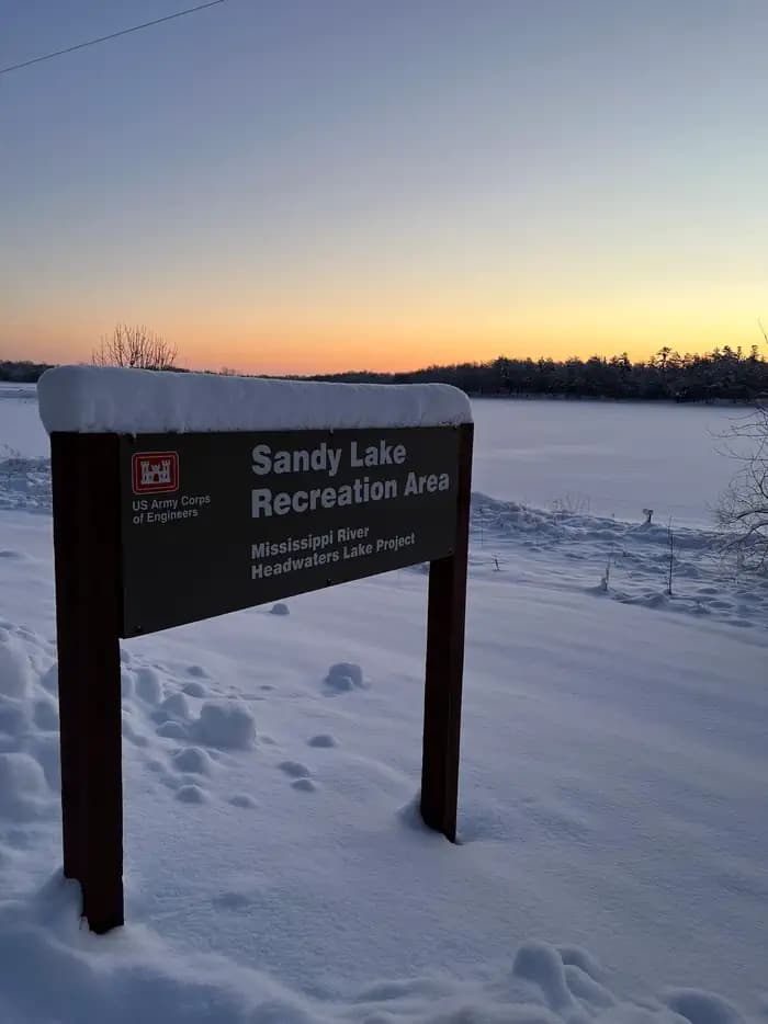
Overview The Sandy Lake Dam and Recreation Area is situated at the outlet of Big Sandy Lake in northern Minnesota, 13 miles north of McGregor, MN. The dam is a part of the Mississippi Headwaters Project, one of the first reservoir systems in the country, and the Sandy Lake Dam structure dates back to 1895. Today the grounds have been developed into a park and campground that is noted for its clean, family-friendly environment and access to fishing and boating on both the lake and nearby Mississippi River. It offers the only public campground and beach on Big Sandy Lake. The area is also a part of the historic canoe route that connected the Mississippi River to Lake Superior and major fur trading companies. Artifacts from the area's long history are kept in a small museum located near the dam. Recreation Sandy Lake offers many recreational opportunities including camping, boating, swimming, picnicking, birding and hiking. Anglers enjoy fishing the lake and river for Northern pike, walleye, small mouth bass, bluegill, crappie and even catfish. Playgrounds are located on both sides of the dam and are located near the beach and visitor museum areas. The old lock house has been converted into a free small museum containing historical artifacts from the area. Educational programs are offered seasonally and are open to the public. Facilities Sandy Lake offers many recreational opportunities including camping, boating, swimming, picnicking, birding and hiking. Anglers enjoy fishing the lake and river for Northern pike, walleye, small mouth bass, bluegill, crappie and even catfish. Playgrounds are located on both sides of the dam and are located near the beach and visitor museum areas. The old lock house has been converted into a free small museum containing historical artifacts from the area. Educational programs are offered seasonally and are open to the public. Natural Features Big Sandy Lake is a reservoir that was created in the late nineteenth century from the waters of a naturally exisiting lake and the Sandy River. A forest of mixed hardwoods and towering red and white pine covers the area. An abundance of wildlife can be found including bald eagles, white-tail deer, black bears, chipmunks, loons, mink, river otters and many others. Wild rice is harvested from the lake seasonally and wild berries are occasionally found. Nearby Attractions Nearby attractions include golf courses, shopping and dining venues, Savannah Portage State Park, Rice Lake National Wildlife Refuge, and many acres of state and county forest land.
View details →
Overview Gull Lake Recreation Area offers something for everyone with boating, hiking, fishing and swimming at Minnesota's famous Gull Lake, the largest of the 10 lakes on the Gull Chain of Lakes. Visitors have the opportunity to see and hear an abundance of watchable wildlife like bald eagles, white-tailed deer, river otters, a variety of songbirds, and the legendary call of the loon. Recreation Anglers will delight in the large population of fish including stocked walleye, northern pike, bass and a variety of panfish. Boaters can access crystal clear waters throughout the chain of lakes and enjoy the peaceful sunsets overlooking the woods. Hit the self-guided interpretive trail for a short hike with wildlife watching and scenic overlooks along the lake. Hop on your bike on the City of East Gull Lake's paved multi-use trail that starts by the dam, or head out to join up with the Paul Bunyan State Trail with trailheads located in Baxter and Nisswa. Got a kayak, canoe, or intertube? Try heading down the Gull River from the lower canoe launch. Ask the Park Rangers about river safety with current water flow and check-out a life jacket before you go. Facilities Anglers will delight in the large population of fish including stocked walleye, northern pike, bass and a variety of panfish. Boaters can access crystal clear waters throughout the chain of lakes and enjoy the peaceful sunsets overlooking the woods. Hit the self-guided interpretive trail for a short hike with wildlife watching and scenic overlooks along the lake. Hop on your bike on the City of East Gull Lake's paved multi-use trail that starts by the dam, or head out to join up with the Paul Bunyan State Trail with trailheads located in Baxter and Nisswa. Got a kayak, canoe, or intertube? Try heading down the Gull River from the lower canoe launch. Ask the Park Rangers about river safety with current water flow and check-out a life jacket before you go. Natural Features The campground sits on the Gull River at the outlet of Gull Lake. The area was formed by a receding glacier that moved southward from Canada and carved the landscape. Gull Lake is one of the six Mississippi Headwaters Projects of the Mississippi River Watershed operated by The U.S. Army Corps of Engineers. Nearby Attractions Gull Lake is located minutes from 520 holes of golf, the 100-mile Paul Bunyan State Trail, amusement parks, a zoo, and numerous shopping opportunities in Brainerd, Baxter, and Nisswa.
View details →
Overview Cut Foot Sioux Horse Camp is located northeast of Lake Winnibigoshish. Over 120 miles of forest roads and recreation trails surround this scenic campground, making it a favorite location of campers with horses. Recreation Many miles of trails pass through or begin at Cut Foot Horse Camp, leading horseback riders, hikers, and mountain bikers through the Cut Foot Experimental Forest. Several trails are also open to off-road vehicles. Research areas are designated by various markers. Please leave the markers as you find them. Facilities Many miles of trails pass through or begin at Cut Foot Horse Camp, leading horseback riders, hikers, and mountain bikers through the Cut Foot Experimental Forest. Several trails are also open to off-road vehicles. Research areas are designated by various markers. Please leave the markers as you find them. Natural Features The campground lies within the Cut Foot Experimental Forest, managed in part by the North Central Research Station in Grand Rapids and the Chippewa National Forest. A mature stand of red pine covers the area, with oak and birch trees dotting the forest. The campground has nice shade and good privacy between sites. Nearby Attractions Boating, swimming, and fishing are popular activities on Big and Little Cut Foot Sioux Lakes and Lake Winnibigoshish. These lakes and several others are within a few miles of the campground.
View details →
Overview Fenske Lake Campground offers visitors an escape to a small, remote campground with large, majestic pine trees and easy access to water. It is a popular base camp for exploring, fishing, hiking, sightseeing and backcountry canoeing in Superior National Forest and the nearby Boundary Waters Canoe Area Wilderness. The campground lies approximately 10 miles outside of Ely, Minnesota. Recreation Because of its proximity to access points into the Boundary Waters Canoe Area Wilderness and its status as a Superior National Forest canoe circle route, Fenske Lake is very popular for canoeing and kayaking. Families and children enjoy exploring the short, 1-mile nature trail in the campground, as well as swimming at the grassy beach or waiting for a catch on the accessible fishing pier. Anglers can make use of the boat ramp and try their luck for bass, northern pike, crappie and sunfish. View recreation guides and maps of hiking trails and canoe routes in the national forest. Facilities Because of its proximity to access points into the Boundary Waters Canoe Area Wilderness and its status as a Superior National Forest canoe circle route, Fenske Lake is very popular for canoeing and kayaking. Families and children enjoy exploring the short, 1-mile nature trail in the campground, as well as swimming at the grassy beach or waiting for a catch on the accessible fishing pier. Anglers can make use of the boat ramp and try their luck for bass, northern pike, crappie and sunfish. View recreation guides and maps of hiking trails and canoe routes in the national forest. Natural Features The facility overlooks 130-acre Fenske Lake, a small and scenic body of water surrounded by dense hardwood and pine forests in the northwoods of Minnesota. Birds and wildlife are abundant in the area. Superior National Forest, located in northeastern Minnesota's Arrowhead Region, is comprised of 3-million acres. The forest spans 150 miles along the United States-Canada border. Nearby Attractions Numerous outdoor recreation opportunities lie within Superior National Forest's 77 lake accesses, 13 fishing piers, 10 swimming beaches and 22 picnic areas. The forest is also home to three scenic byways. Campers can also explore the nearby Boundary Waters Canoe Area Wilderness. Over 1-million acres in size, the Boundary Waters extends nearly 150 miles along the United States-Canada border and contains over 1,200 miles of canoe routes, 12 hiking trails and over 2,000 designated campsites. Additional sites of interest
View details →
Overview Birch Lake Campground is located in Superior National Forest near the Boundary Waters Canoe Area Wilderness, about 13 miles from Ely, Minnesota. It is an ideal place to relax while enjoying fishing, boating and other recreational activities. Recreation Fishing, boating and canoeing are popular on Birch Lake. Anglers can use the boat ramp or try their luck from shore to catch northern pike, perch, crappie and walleye. There are no horsepower limitations for boats on the lake. The shoreline is inviting for campers interested in canoeing. Families also enjoy berry picking during the summer and early fall months. View recreation guides and maps of hiking trails and canoe routes in the national forest. Facilities Fishing, boating and canoeing are popular on Birch Lake. Anglers can use the boat ramp or try their luck from shore to catch northern pike, perch, crappie and walleye. There are no horsepower limitations for boats on the lake. The shoreline is inviting for campers interested in canoeing. Families also enjoy berry picking during the summer and early fall months. View recreation guides and maps of hiking trails and canoe routes in the national forest. Natural Features Birch Lake covers 7,628 acres and is one of a series of lakes in the area. The campground lies in aspen and birch forest. Birds and wildlife are abundant. Superior National Forest, located in northeastern Minnesota's Arrowhead Region, is comprised of 3-million acres. The forest spans 150 miles along the United States-Canada border. Nearby Attractions Numerous outdoor recreation opportunities lie within Superior National Forest's 77 lake accesses, 13 fishing piers, 10 swimming beaches and 22 picnic areas. The forest is also home to three scenic byways. Campers can also explore the nearby Boundary Waters Canoe Area Wilderness. Over 1-million acres in size, the Boundary Waters extends nearly 150 miles along the United States-Canada border and contains over 1,200 miles of canoe routes, 12 hiking trails and over 2,000 designated campsites.
View details →
Overview South Kawishiwi River Campground is located in Superior National Forest near the Boundary Waters Canoe Area Wilderness, about 10 miles from Ely, Minnesota. It offers fishing, boating and other recreational activities in a relaxing outdoor setting. The campground has sites with and without electric hookups, as well as one group day use area great for family picnics, birthday parties and other gatherings of up to 35 people. Recreation Canoeing is a main attraction. The Kawishiwi River provides access to Birch Lake to the south and the Boundary Waters to the north. When traveling in the Boundary Waters Canoe Area Wildnerness, a permit is required. Canoe rentals are available by contacting the host. Closer to shore, visitors can enjoy an afternoon of swimming at the campground's grassy beach, hiking the 1-mile Kawishiwi River Forest Trail or trying their luck at fishing for northern pike, perch and walleye. A boat ramp is located on-site. View recreation guides and maps of hiking trails and canoe routes in the national forest. Facilities Canoeing is a main attraction. The Kawishiwi River provides access to Birch Lake to the south and the Boundary Waters to the north. When traveling in the Boundary Waters Canoe Area Wildnerness, a permit is required. Canoe rentals are available by contacting the host. Closer to shore, visitors can enjoy an afternoon of swimming at the campground's grassy beach, hiking the 1-mile Kawishiwi River Forest Trail or trying their luck at fishing for northern pike, perch and walleye. A boat ramp is located on-site. View recreation guides and maps of hiking trails and canoe routes in the national forest. Natural Features The scenic Kawishiwi River boasts clear, cold and calm waters lined with boreal forest and wetland ecosystems. Wildlife abounds in Superior National Forest, from moose and bear to bald eagles and loons. The campground lies in a mixed aspen, birch and conifer forest. Superior National Forest, located in northeastern Minnesota's Arrowhead Region, is comprised of 3-million acres. The forest spans 150 miles along the United States-Canada border. Nearby Attractions Numerous outdoor recreation opportunities lie within Superior National Forest's 77 lake accesses, 13 fishing piers, 10 swimming beaches and 22 picnic areas. The forest is also home to three scenic byways. Campers can also explore the nearby Boundary Waters Canoe Area Wilderness. Over 1-million acres in size, the Boundary Waters extends nearly 150 miles along the United States-Canada border and contains over 1,200 miles of canoe routes, 12 hiking trails and over 2,000 designated campsites. Boundary Waters Canoe Area Wilderness Additional sites of interest
View details →
Overview Mosomo Point Campground is located between Little and Big Cut Foot Sioux Lakes in the heart of the Chippewa National Forest. Visitors enjoy the area for canoeing, trophy muskie fishing, hiking and beautiful scenery. Recreation Canoeing, kayaking and fishing are very popular activities at Mosomo Point. Its protected location on the lake provides calm waters away from the big lake, making it an ideal spot for flatwater paddling. Miles of trails in the area provide great hiking, horseback riding, mountain biking and birding opportunities. The Simpson Creek Trail and Cut Foot Sioux National Recreation Area Trail can be accessed nearby. Cut Foot Sioux Lake is located next to Lake Winnibigoshish, which can be accessed from Cut Foot Sioux. Lake Winnie offers excellent fishing opportunities for walleye, perch and muskie. It is one of Minnesota's premier fisheries. Boating and water skiing are popular activities. Facilities Canoeing, kayaking and fishing are very popular activities at Mosomo Point. Its protected location on the lake provides calm waters away from the big lake, making it an ideal spot for flatwater paddling. Miles of trails in the area provide great hiking, horseback riding, mountain biking and birding opportunities. The Simpson Creek Trail and Cut Foot Sioux National Recreation Area Trail can be accessed nearby. Cut Foot Sioux Lake is located next to Lake Winnibigoshish, which can be accessed from Cut Foot Sioux. Lake Winnie offers excellent fishing opportunities for walleye, perch and muskie. It is one of Minnesota's premier fisheries. Boating and water skiing are popular activities. Natural Features The campground is situated in a transitional area between Little and Big Cut Foot Sioux Lakes. The quieter cove is lined with mature red and white pine trees. The lake is home to a variety of waterfowl and birds of prey, including loons, osprey and bald eagles. Nearby Attractions The Cut Foot Sioux Visitor Information Center is located a half-mile from the campground. The center offers interpretive displays, educational programs, trails and area information. Several resorts in the area offer camping and fishing supplies, groceries and more, and can be reached by watercraft or vehicle.
View details →
Overview Williams Narrows Campground is located on Cut Foot Sioux Lake in the heart of the Chippewa National Forest. Visitors come to the area for boating, trophy muskie fishing and beautiful scenery. Recreation Boating, swimming and fishing are popular activities on Cut Foot Sioux Lake. A boat ramp and swimming beach are located between the campground's two loops. Miles of trails in the area provide great hiking, horseback riding, mountain biking and birding opportunities. The Simpson Creek Trail and Cut Foot Sioux National Recreation Area Trail can be accessed by boating across the narrows. Cut Foot Sioux Lake is located next to Lake Winnibigoshish. Lake Winnie offers excellent fishing opportunities for walleye, perch and muskie. It is one of Minnesota's premier fisheries. Boating and water skiing are popular activities there. Facilities Boating, swimming and fishing are popular activities on Cut Foot Sioux Lake. A boat ramp and swimming beach are located between the campground's two loops. Miles of trails in the area provide great hiking, horseback riding, mountain biking and birding opportunities. The Simpson Creek Trail and Cut Foot Sioux National Recreation Area Trail can be accessed by boating across the narrows. Cut Foot Sioux Lake is located next to Lake Winnibigoshish. Lake Winnie offers excellent fishing opportunities for walleye, perch and muskie. It is one of Minnesota's premier fisheries. Boating and water skiing are popular activities there. Natural Features The campground is situated on the eastern shore of Cut Foot Sioux Lake. A scenic forest of birch, oak and pine trees shades the campground. A few campsites have lake views. The lake is home to a variety of waterfowl and birds of prey, including loons, osprey and bald eagles.
View details →
Overview McDougal Lake Campground provides easy access to a wide variety of recreational activities including hiking, boating, fishing, picnicking and swimming within the central part of Superior National Forest. Superior National Forest, located in northeastern Minnesota's arrowhead region, is comprised of three million acres. The forest spans 150 miles along the United States-Canada border. Visitors can find recreation opportunities year-round, including travel in the famous Boundary Waters Canoe Area Wilderness. The one-mile hiking trail and campsites 17 and 19 were closed in 2021 due to impacts from the Greenwood Fire and will be closed until further notice. Recreation Kids will love the sandy swimming beach within the facility. A boat ramp and shoreline access provide anglers the opportunity for a leisurely afternoon of fishing for walleye and northern pike. Facilities Kids will love the sandy swimming beach within the facility. A boat ramp and shoreline access provide anglers the opportunity for a leisurely afternoon of fishing for walleye and northern pike. Natural Features The 323-acre McDougal Lake is surrounded by a thick forest of birch, maple and pine and sits at an elevation of 1,800 ft. The area is peaceful, rustic and begs for relaxation. One unique feature of the lake is the wild rice growing within it. Birds and wildlife frequent its shores. Nearby Attractions Numerous outdoor recreation opportunities lie within Superior National Forest's 77 lake access areas, 13 fishing piers, 10 swimming beaches and 22 picnic areas. The forest is also home to three scenic byways. contact_info For facility specific information, please call (218) 663-8060.
View details →
Overview Ninemile Lake Campground is perfect for people wanting to do some exploring while camping. A boat ramp leads to Ninemile Lake, complete with islands and hidden bays. For birders and hikers, there is a trail through boreal hardwoods, beginning across the road from the campground entrance, with 0.5 miles of maintained hiking trail. North of the campground, on County 7, is access to Echo Lake, a portage access to Goldeneye Lake. Recreation Ninemile Lake is close to 300 acres in size. It is a popular fishing spot for walleye, northern, bass, and pan fish. The surrounding National Forest offers a wide variety of recreational opportunities, including hiking in secluded woodlands, canoeing, and hunting. Facilities Ninemile Lake is close to 300 acres in size. It is a popular fishing spot for walleye, northern, bass, and pan fish. The surrounding National Forest offers a wide variety of recreational opportunities, including hiking in secluded woodlands, canoeing, and hunting. Natural Features The area is scenic and easily accessible. Superior National Forest is known for its boreal forest ecosystem, numerous clean lakes, diversity of plants and animals, and colorful cultural history. Nearby Attractions Numerous outdoor recreation opportunities lie within Superior National Forest's 77 lake access areas, 13 fishing piers, 10 swimming beaches, and 22 picnic areas. The forest is also home to three scenic byways. contact_info For facility specific information, please call (218) 663-8060. Charges & Cancellations Rules and Reservation Policies
View details →
Overview ** All frontcountry and backcountry campsites require travel by private watercraft or water taxi to access. Click on any campsite name when searching sites to view boating distances. ** Voyageurs National Park has 147 frontcountry, 14 backcountry, and 2 primitive campsites for visitors wanting an authentic northwoods camping experience. PRIMITIVE CAMPSITES (Red Pine & Blueberry Ridge) are the only campsites that are located on the mainland and DO NOT require a boat to access. They are hike-in sites along the Kab-Ash Trail and are equipped only with fire rings and cleared areas for tents. Leave No Trace Principles apply in these areas. FRONTCOUNTRY CAMPSITES are located on the large lakes (Rainy, Kabetogama, Namakan, Sandpoint). You can boat directly to them from any park visitor center boat ramp. They offer fire rings, tent pads, picnic tables, bear lockers for safe food storage, and outdoor privies. Use the Build Itinerary button to plan a frontcountry camping trip. BACKCOUNTRY CAMPSITES are located on the park's interior lakes and offer a more remote and secluded camping experience consisting of fire rings, tenting areas, an outdoor privy, a bear pole for safe food storage, and a canoe. These sites first require travel by private watercraft or local water taxi service to a remote trailhead and then hiking up to several miles to the backcountry lakes. All backcountry campsite reservations include the use of one canoe and an access code will be provided in your confirmation email. Some campsites can be hiked to directly while others require paddling after hiking. Canoes on backcountry lakes are provided by the park and remain stationed at these lakes. Personal watercrafts of any kind can not be portaged into backcountry . Use the Build Itinerary button to plan a backcountry camping trip. Chain of Lakes (Locator, War Club, Quill, and Loiten Lakes): Reservations at these sites automatically include one canoe because a canoe is required to reach them. In this area only, up to 2 additional canoes can be added on a first come, first served basis. Shoepack & Little Shoepack Lakes: The campsites on these two lakes come reserved together (for the cost of one) because the one canoe on Little Shoepack is required to reach the campsite on Little Shoepack and/or the portage to Shoepack Lake. Shoepack Lake has its own separate canoe - please leave the canoes on their respective lakes. Ek, Agnes, Jorgens, Quarter Line, Cruiser, Brown, Peary, Oslo and Ryan Lakes: These backcountry campsites can be hiked to directly after boating to a trailhead and have one canoe located at each site. DAY USE BACKCOUNTRY CANOE RENTALS: The Chain of Lakes is the only backcountry area with an additional inventory of canoes that are available for single day use. Use of these canoes first requires travel by private watercraft or local water taxi service to the Locator trailhead, and then hiking two miles to where the rental canoes are stationed. To reserve a day use canoe in the Chain of Lakes area, click on the Reserve Day Use Rentals button or scroll further down on this page to view canoe options and availability. To use the canoe at any other backcountry site for day use, that campsite must be reserved for one overnight. DAY USE & VISITOR DESTINATION SITES: With 27 Day Use sites and 7 Visitor Destination sites, Voyageurs National Park has plenty of areas to enjoy for visitors who are out for a day trip on the lakes. Each Day Use site has picnic tables, fire rings and vault privies, while the Visitor Destination sites offer short trails with wayside exhibits, picnic areas and comfort stations. No reservations are required for Day Use or Destination sites. You can view a map of day use sites here . Keep Voyageurs National Park Wild for Future Generations: The Voyageurs Conservancy is the park's official nonprofit partner representing a community of people who care about the ongoing stewardship of Voyageurs National Park. VNPA works to fund projects and programs that will help sustain the park's waters, wild character, and visitor experience for generations to come. Become a member today , follow them on Facebook and Instagram , or sign up for their e-newsletter . Recreation From spring through fall, explore Voyageurs National Park on land by stopping in at a visitor center or hiking any of our 52 miles (84 km) of scenic hiking trails. To explore the vastness of the same lakes the Voyageurs and Ojibwe Indians once traversed, leave your car behind and explore park waters by kayak, canoe, sailboat, motorboat, houseboat or tour boat. Public boat launch ramps are available at park visitor centers, the Crane Lake ranger station and the two state forest campgrounds - Woodenfrog and Ash River. With scheduled programs and boat tours, you can paddle a canoe on the Voyageurs Highway, watch wildlife by day and stars by night, and explore historic Kettle Falls Hotel, Hoist Bay and Ellsworth Rock Gardens. Check the Things to Do page on the park website for a current list of these activities and many more, or speak with a park ranger at one of the Voyageurs National Park visitor centers. Many of our programs offer reservations. Visit the Voyageurs National Park Tours or the Voyageurs National Park Special Interpretive Programs pages (reservations are highly recommended for boat tours). Facilities From spring through fall, explore Voyageurs National Park on land by stopping in at a visitor center or hiking any of our 52 miles (84 km) of scenic hiking trails. To explore the vastness of the same lakes the Voyageurs and Ojibwe Indians once traversed, leave your car behind and explore park waters by kayak, canoe, sailboat, motorboat, houseboat or tour boat. Public boat launch ramps are available at park visitor centers, the Crane Lake ranger station and the two state forest campgrounds - Woodenfrog and Ash River. With scheduled programs and boat tours, you can paddle a canoe on the Voyageurs Highway, watch wildlife by day and stars by night, and explore historic Kettle Falls Hotel, Hoist Bay and Ellsworth Rock Gardens. Check the Things to Do page on the park website for a current list of these activities and many more, or speak with a park ranger at one of the Voyageurs National Park visitor centers. Many of our programs offer reservations. Visit the Voyageurs National Park Tours or the Voyageurs National Park Special Interpretive Programs pages (reservations are highly recommended for boat tours). Natural Features Voyageurs National Park is a land and water environment of great beauty, exceptional natural and cultural resources, and abundant recreational opportunities. Located in the lake-country of northern Minnesota, the park protects 218,054 acres (88,243 ha) that include roughly 134,000 acres (54,227 ha) of forest, 84,000 acres (33,993 ha) of water, 655-miles (1,054 km) of undeveloped shoreline, and hundreds of islands. The park's 55-mile (89 km) northern boundary is the international border between the United States and Canada and includes an important segment of the "transcontinental highway" traversed by French-Canadian voyageurs during the late 1700s and early 1800s. There are four distinct seasons in Voyageur country. The air is mild during June, July, and August when periods of fine, warm weather prevail. The frost-free season averages 120 days from June to mid-September. The average ice-out date is May 3 but varies year to year. Annual precipitation (rain and snow) averages 25-28 inches (63-71 cm) in the park and average snowfall ranges from 55-70 inches (140-180 cm), but is highly variable. The first measurable snowfall occurs in late October and the last in late April or early May. Nearby Attractions Unique attractions near Voyaguers National Park: The City of International Falls sits on the U.S.-Canada borde r, across from Fort Frances, Ontario. You can have a picnic lunch in Smokey Bear Park, and then tour the Bronko Nagurski Museam and Koochiching County Historical Museum, which both sit on site. Don't forget to take a photo with the 26-foot statue of Smokey the Bear himself - a well-known and beloved national symbol of fire prevention and forest conservation. There are many unique businesses and shops along main street, as well as some great coffee shops and restaurants. Heading eastward out of town, you will pass the village of Ranier and numerous resorts where you can find delicious lake-side dining, fishing guides, hotel and cabin accomodations, houseboat rental companies and much more. The Historic Port Village of Ranier is a quaint little community situa ted right where Rainy Lake empties into the Rainy River underneath a cantilever-style train bridge that spans from the U.S. into Canada. Here you will find lodging, an RV park, a park and playground, a public beach, public docks, delicous food, an ice cream parlor and a lakeside brewpub, all packed into one small charming town of about 150 residents. Be sure to take a photo with Big Vic, the 25-foot (8 m) tall statue of a French-Canadian voyageur, who stands at the entrance to this unique little town. The communites of Kabetogama , and Ash River , and Crane Lake are located 30 to 60 miles south of International Falls, and serve as gateways to the southern district Voyageurs National Park. Be sure to stop and take a photo of yourself "riding" the walleye statue at the entrance to Kabetogama on Highway 53. contact_info For facility specific information, please call (218) 283-6650. Charges & Cancellations CANCELLATION POLICY: Cancellations and/or modifications to an existing reservation can easily be made online via your recreation.gov account. Log in to your account, click on your name in the upper right, and select My Reservations. Click on the "Modify or Cancel" button next to the reservation needing to be changed. The national recreation.gov call center at (877) 444-6777 can also assist. You cannot call a park office to cancel a reservation. THE FOLLOWING FEES APPLY: Reservation system fee of $10 charged at time of reservation is non-refundable Any change (i.e. trip dates, campsite) to your reservation more than 3 days prior to your trip: No charge Any change (i.e. trip dates, campsite) to your reservation less than 3 days prior to your trip: $10 service fee per Cancel reservation more than 3 days prior to arrival date: additional $10 cancellation fee; receive refund of remaining amenity fees Cancel reservation less than 3 days prior to arrival date: additional $10 cancellation fee + forfeit first night’s fee; receive refund of remaining amenity fees Once permit has been printed : No refund; printing your permit confirms your reservation and must be done within 5 days of your trip start date from the My Reservations section of your recreation.gov account Once trip dates have started : No refund; if you are unable to make your trip, cancel your reservation in the My Reservations section of your recreation.gov account before your trip start date to be eligible for a refund
View details →
Overview Little Isabella River Campground is a small, secluded campground in a grove of red and white pines in the central part of Superior National Forest, just 4.5 miles west of Isabella, Minnesota. This is a great campground for campers seeking a quiet spot in the woods and anglers interested in fishing the Little Isabella River. The Superior National Forest, located in northeastern Minnesota's arrowhead region, is comprised of three million acres. The Forest spans 150 miles along the United States-Canada border. Visitors can find recreation opportunities year-round, including travel in the famous Boundary Waters Canoe Area Wilderness. Recreation The Little Isabella River, a small stream with occasional riffles, is a popular fishing spot for brook trout. The surrounding national forest offers a wide variety of recreational opportunities, including hiking in secluded woodlands, canoeing and hunting. Facilities The Little Isabella River, a small stream with occasional riffles, is a popular fishing spot for brook trout. The surrounding national forest offers a wide variety of recreational opportunities, including hiking in secluded woodlands, canoeing and hunting. Natural Features The campground lies among towering red pine trees at an elevation of 1,900 ft. The area is scenic and secluded. The Superior National Forest is known for its boreal forest ecosystem, numerous clean lakes, diversity of plants and animals, and colorful cultural history. contact_info For facility specific information, please call (218) 663-8060. Nearby Attractions Numerous outdoor recreation opportunities lie within the Superior National Forest's 77 lake access areas, 13 fishing piers, 10 swimming beaches, and 22 picnic areas. The forest is also home to three scenic byways. Charges & Cancellations Changes and cancellations are allowed up to 48 hours prior to date of arrival.
View details →FAQ
Camping in Minnesota
How many campgrounds are listed in Minnesota?
TheCampVerse currently lists 38 campgrounds in Minnesota.
What campground types are most common in Minnesota?
The most common campground types are Campground.
How can I compare campgrounds in Minnesota?
Use the campground cards and featured links on this page to compare descriptions, amenities, and details before opening each campground profile.
Keep exploring